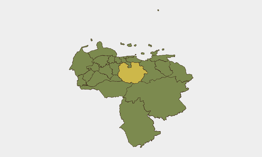
Situation Summary
Venezuela remains a composite-threat environment (#42 globally, score 50) shaped primarily by post-earthquake infrastructure collapse, persistent political instability, and elevated opportunistic crime rather than acute armed conflict. The June 24 earthquakes have deepened service disruptions across Caracas and coastal zones, restricting air travel and creating secondary security gaps in damaged urban areas. Spontaneous civil unrest, militia checkpoints, and kidnapping remain chronic risks; no major new violence events have been confirmed in the past 24–48 hours, but the underlying fragility—compounded by humanitarian operations and strained state capacity—sustains elevated corporate-security and duty-of-care requirements.
Key Developments
- Caracas & La Guaira (Vargas State) – 2026-07-14/15: Electricity, phone, and gas services remain intermittently disrupted following the June 24 earthquakes; ongoing infrastructure repairs have not restored full connectivity, leaving damaged districts vulnerable to increased crime and delayed emergency response.
- Simón Bolívar International Airport (Caracas, CCS) – through end-July 2026: Commercial operations remain closed; only humanitarian flights are permitted. This closure extends international-travel bottlenecks and forces dependence on overland routes with higher robbery and checkpoint risks.
- Multiple urban centers – 2026-07-14/15: Authorities and foreign ministries continue to report that spontaneous demonstrations and road blockages remain possible at short notice amid the political and economic crisis; violent clashes with security forces have occurred in recent protests.
- Nationwide checkpoints and militia activity – persistent through 2026-07-15: Colectivos and state security forces maintain ad hoc vehicle and identity checks (alcabalas) on major roads and in city districts, particularly at night; extortion and detention remain documented risks.
- La Guaira & coastal disaster zones – 2026-07-14/15: Large-scale UN and international humanitarian operations continue in heavily damaged districts; strained local policing capacity and displaced populations elevate risks of opportunistic crime and looting around aid distribution points.
Highest-Risk Areas
Guarico State (63.2) emerges as the single highest-risk jurisdiction, likely reflecting militia activity, checkpoint prevalence, and governance gaps in a rural-interior region. The Federal District (45) remains a secondary concern due to urban density, protests, and infrastructure vulnerability; Carabobo, Lara, and Vargas States (36.8–35.2) follow, with Vargas experiencing acute earthquake-related degradation of security services. The concentration of risk in interior agricultural and rural zones (Guarico, Barinas, Tachira) alongside coastal and metro regions indicates that both trafficking/militia corridors and urban civil unrest pose distinct threats; corporate assets and personnel in the capital and major urban centers should prioritize infrastructure resilience and situational awareness, while operations in Guarico and adjacent states face higher checkpoint and extortion risk.
How GeoBit Would Assist
Security teams should deploy AOI Monitoring & Early Warning on Caracas, major transit corridors, and the Federal District to detect protest formation and checkpoint activity in near-real time. Intel Sweep and X/Telegram OSINT capabilities provide 24-hour signal of militia communications, government security announcements, and ad hoc road closures. Routing & Network Analysis enables identification of checkpoint-avoiding or lower-risk overland routes and alternative airport access, while Satellite & Imagery Analysis tracks infrastructure recovery and humanitarian-operation intensity in quake-affected zones.
7-Day Outlook
Infrastructure repairs in Caracas will likely remain incomplete; airport closure will persist through end-July. Spontaneous urban protests are probable given the political and economic backdrop, though no imminent large-scale violence is signaled. Checkpoint and militia activity will continue; personnel movement and supply-chain risk will remain elevated, particularly in Guarico, Lara, and coastal corridors.
Highest-Risk Areas — Ranked
| # | State / Region | Risk |
|---|---|---|
| 1 | Guarico State | 63.2 |
| 2 | Federal District | 45 |
| 3 | Carabobo State | 36.8 |
| 4 | Lara State | 35.9 |
| 5 | Vargas State | 35.2 |
| 6 | Anzoategui State | 33.6 |
| 7 | Zulia State | 33.4 |
| 8 | Tachira State | 33.4 |
| 9 | Falcon State | 33.2 |
| 10 | Federal Dependencies | 33.2 |
| 11 | Nueva Esparta State | 33.2 |
| 12 | Barinas State | 33.2 |
Sources
Previous Daily Briefs
A new Venezuela brief is written every day — each with its own risk map and downloadable CSV. Here's the last week; use the calendar to go further back.
📅 Browse every day by calendar →
Highlighted days have a brief. Tap a day for that day's map & analysis, or “csv” for that day's dataset ($5).
Atlas — our AI intelligence desk — emails them this snapshot personally. Nothing else, no list.