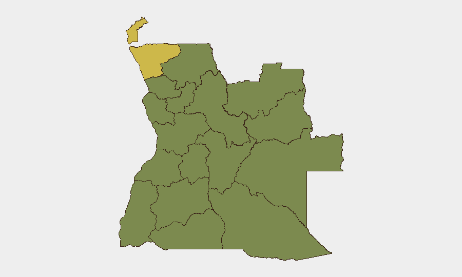
Situation Summary
Angola maintains a composite threat ranking of #46 globally, with a stable but fragmented risk profile dominated by subnational instability in Cabinda and Zaire provinces (both scoring 62.8). Open-source monitoring indicates a quiet operational period over the last 24–48 hours, with no verified new security incidents, civil unrest, attacks, or infrastructure failures reported. Underlying structural risks—armed crime in urban centers, localized tensions in diamond-rich and border regions, and ongoing public-health concerns—remain unchanged and require sustained monitoring rather than response to acute events.
Key Developments
No verified new security, conflict, civil-unrest, crime, or infrastructure incidents have been documented in Angola during the last 24–48 hours (as of 20 July 2026). Open-source intelligence, social-media monitoring, and real-time feeds confirm an absence of discrete, time-stamped incidents such as riots, attacks, major protests, or service disruptions in this window.
Situational note: Nationwide security posture remains characterized by persistent but stable structural risks—elevated armed crime in Luanda Province, localized tensions in Cabinda, Lunda Norte, Lunda Sul, and Moxico provinces, and a continuing cholera outbreak in vulnerable regions—without acute incident escalation or new outbreak zones documented in the past 48 hours.
Highest-Risk Areas
Cabinda and Zaire provinces (both 62.8 composite risk) account for Angola's most acute threats, reflecting a combination of historical separatist tension, porous borders, trafficking networks, and sparse state presence. A second tier—Lunda Norte, Lunda Sul, Bengo, Luanda, and Uíge provinces (all 32.8)—faces elevated risk from diamond-mining criminality, cross-border instability, and urban crime concentration, with Luanda's armed-crime environment particularly relevant to multinational corporate and NGO operations. The disparity between top-tier and second-tier provinces suggests that threat drivers are geographically concentrated rather than nationwide, permitting differentiated duty-of-care and asset-protection strategies by region.
How GeoBit Would Assist
Intel Sweep, OSINT fusion, and multi-language web/social monitoring enable real-time detection of emerging incidents in Cabinda, Lunda, and Luanda before they escalate, alerting security teams to protests, labor unrest, or armed activity within hours. AOI (Area-of-Interest) Monitoring & Early Warning on key facilities, logistics hubs, and travel corridors provides persistent watch and threshold-based alerting for personnel and asset safety. GIS & Spatial Analysis, satellite imagery review, and routing/network analysis support alternative-route planning and site-security assessments in high-risk provinces, enabling teams to anticipate chokepoints and optimize duty-of-care protocols around known instability zones.
7-Day Outlook
No acute escalation is forecast over the next 7 days; the security environment is expected to remain consistent with current subnational patterns. Cholera-outbreak monitoring and cross-border trafficking activity in northern provinces warrant continued baseline surveillance. Seasonal wildfire activity (currently tracking 10+ active incidents) may indirectly affect transportation and air quality in affected regions; corporate operations dependent on transport or logistics should monitor provincial fire-service alerts and air-quality indices in real time.
Highest-Risk Areas — Ranked
| # | State / Region | Risk |
|---|---|---|
| 1 | Cabinda Province | 62.8 |
| 2 | Zaire Province | 62.8 |
| 3 | Lunda Norte Province | 32.8 |
| 4 | Lunda Sul Province | 32.8 |
| 5 | Bengo Province | 32.8 |
| 6 | Luanda Province | 32.8 |
| 7 | Uíge Province | 32.8 |
| 8 | Cuanza Norte Province | 32.8 |
| 9 | Cuanza Sul Province | 32.8 |
| 10 | Malanje Province | 32.8 |
| 11 | Bié Province | 32.8 |
| 12 | Moxico Province | 32.8 |
Previous Daily Briefs
A new Angola brief is written every day — each with its own risk map and downloadable CSV. Here's the last week; use the calendar to go further back.
📅 Browse every day by calendar →
Highlighted days have a brief. Tap a day for that day's map & analysis, or “csv” for that day's dataset ($5).
Atlas — our AI intelligence desk — emails them this snapshot personally. Nothing else, no list.