Situation Summary
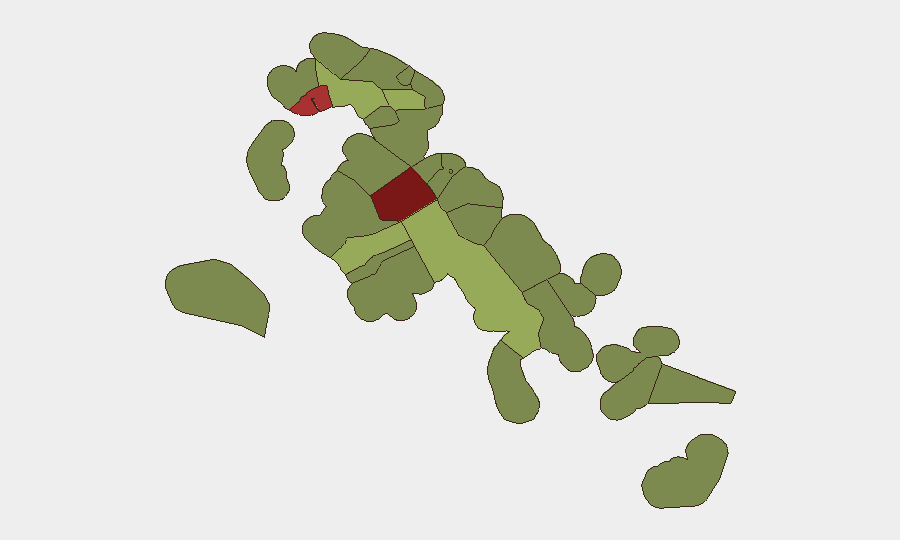
The Bahamas remains a jurisdiction of moderate global concern (rank #79, composite threat 21) with crime and gang activity as the primary security driver. New Providence—home to Nassau and the capital—dominates the national risk profile with a composite score of 92, significantly outpacing all other regions. Violence remains episodic and concentrated in specific urban zones rather than systemic; however, recent August 2026 incidents confirm that homicide, firearms trafficking, and institutional accountability gaps persist as operational hazards for corporate and diplomatic personnel.
Key Developments
- Nassau, New Providence — 2026-08-19: Bahamian authorities conducted a firearm and ammunition seizure with arrest in Gambier Village, indicating ongoing law-enforcement action against illegal weapons supply chains.
- Nassau, New Providence — 2026-08-18: A fatal shooting was reported near a commercial establishment in Nassau, marked as the 47th recorded homicide in the jurisdiction year-to-date.
- Nassau, New Providence — 2026-08-17: A 30-year-old male was fatally shot on Fire Trail Road East during mid-week violence across Nassau, reflecting a recurring pattern of street-level homicide in residential and commercial corridors.
- Nassau, New Providence — 2026-08-14 (reported 2026-08-21): A police constable was formally charged in connection with the death of a 10-month-old infant following a traffic incident on Prince Charles Drive, signaling potential institutional accountability measures and operational stress within law enforcement.
- Regional trend (last 48h): Live web research identified limited independently verified new incident reporting beyond Nassau. General travel advisories remain in effect for Nassau and Freeport; no substantive policy or security-posture changes were announced.
Highest-Risk Areas
New Providence (score 92) and the City of Freeport (score 78) account for approximately 75% of sub-national risk concentration. New Providence's dominance reflects both population density and entrenched gang and narcotics-trafficking activity in zones including Gambier Village, Fire Trail Road corridors, and inner-Nassau commercial districts. Freeport carries elevated risk owing to similar transnational crime vectors and port-related vulnerability. Secondary-tier jurisdictions (Central Abaco, Central Andros, Exuma) register lower but non-trivial scores, suggesting diffuse but lower-intensity crime presence across the Out Islands; corporate assets and personnel outside Nassau should maintain baseline vigilance but face materially lower direct threat.
How GeoBit Would Assist
Corporate security teams should deploy Intel Sweep and multi-language OSINT fusion to monitor Bahamian media, law-enforcement statements, and gang-affiliated social channels for early warning of violence escalation or institutional breakdown. AOI Monitoring and Early Warning with persistent geofencing around high-risk Nassau zones (Gambier Village, Fire Trail Road, inner-harbor commercial districts) and Freeport would enable real-time alerting of incident clusters or personnel movement into active threat zones. Network and Actor Analysis, combined with maritime tracking (for drug-smuggling route interdiction), provides longer-horizon insight into transnational crime group activity and supply-chain vulnerabilities affecting personnel safety.
7-Day Outlook
No significant policy, security-posture, or operational changes are forecast for the near term. Homicide and firearms incidents will likely continue at baseline rates in New Providence; institutional investigations (e.g., the police constable case) may yield minor policy adjustments but are unlikely to materially alter street-level risk within seven days. Personnel and asset managers should sustain current situational awareness protocols and maintain communication with local law-enforcement liaison offices.
Highest-Risk Areas — Ranked
| # | State / Region | Risk |
|---|---|---|
| 1 | New Providence | 92 |
| 2 | City of Freeport | 78 |
| 3 | Central Abaco | 52 |
| 4 | Central Andros | 48 |
| 5 | Exuma | 45 |
| 6 | East Grand Bahama | 42 |
| 7 | South Andros | 38 |
| 8 | North Abaco | 35 |
| 9 | North Eleuthera | 33 |
| 10 | South Abaco | 32 |
| 11 | Cat Island | 30 |
| 12 | Mangrove Cay | 28 |
Sources
Previous Daily Briefs
A new Bahamas brief is written every day — each with its own risk map and downloadable CSV. Here's the last week; use the calendar to go further back.
- August 21, 2026
- August 19, 2026
- August 17, 2026
- August 15, 2026
- August 13, 2026
- August 12, 2026
- August 11, 2026
📅 Browse every day by calendar →
Highlighted days have a brief. Tap a day for that day's map & analysis, or “csv” for that day's dataset ($5).
Atlas — our AI intelligence desk — emails them this snapshot personally. Nothing else, no list.