Situation Summary
The Bahamas remains a Level 2 (exercise increased caution) jurisdiction with violent crime, armed robbery, and burglary as the primary threat vectors. New Providence (Nassau) and Freeport continue to drive national risk, accounting for the majority of recorded incidents. Over the past week (through 2026-08-26), Nassau experienced a sustained spike in firearm violence targeting civilians and involving armed robbery, with at least five separate shooting incidents recorded. No confirmed major security incidents have been reported in the past 24–48 hours; threat posture remains elevated but without new triggering events.
Key Developments
- 2026-08-26 · Nassau (Palm Beach Street/Cordeaux Avenue) — Police officer discharged firearm at male suspect; suspect hospitalized. Incident suggests heightened police engagement in response to ongoing violence cycle.
- 2026-08-25 · Nassau (Kennedy Drive) — 25-year-old male shot by two masked armed robbers during commercial robbery; victim hospitalized. Pattern consistent with organized armed robbery targeting individuals leaving business establishments.
- 2026-08-22 · Exuma Cays (joint RBPF/U.S. OPBAT operation) — Interdiction of approximately 84 cocaine packages, one firearm, and ammunition. Indicates drug trafficking and weapon smuggling remain active vectors in outer islands.
- 2026-08-21 to 2026-08-23 · Nassau (multiple locations) — Three separate homicides (Soldier Road/Blue Hill Road, Joe Farrington Road, Gladstone Road north of Fire Trail Road) over three consecutive days. Cluster pattern suggests possible gang or territorial violence activity, though attribution remains unclear.
- No verified incidents reported 2026-08-31 to 2026-09-02 — Web research and current feeds have not surfaced credible breaking security developments in the past 48 hours.
Highest-Risk Areas
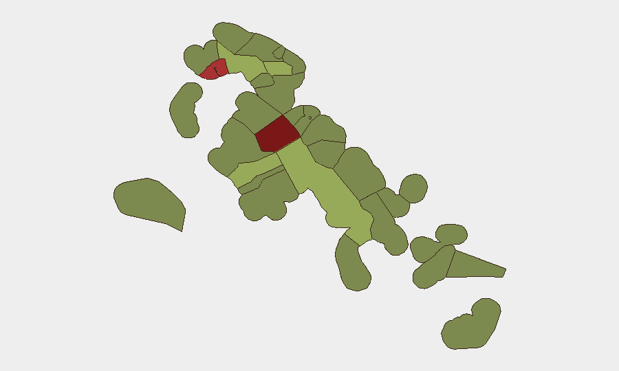
New Providence (composite risk 92) and Freeport (78) remain the primary drivers of national threat exposure, reflecting their population density, commercial activity, and documented gang and narcotics presence. Within Nassau proper, Fox Hill, Kennedy Drive, Soldier Road, and Blue Hill Road corridors have exhibited elevated violent-crime clustering in the past week. Central Abaco (52) and Central Andros (48) show secondary risk elevation, likely tied to trafficking and transnational organized crime infrastructure rather than street-level violence. Corporate teams with personnel or assets in New Providence should apply heightened duty-of-care protocols; Freeport and family-islands operations warrant baseline monitoring but do not currently present acute threats above the national Level 2 advisory.
How GeoBit Would Assist
Security teams would employ AOI Monitoring & Early Warning to establish persistent, automated watch over high-risk Nassau corridors (Fox Hill, downtown commercial zones, airport approaches) and Freeport, with alert thresholds calibrated to specific incident types (homicide clusters, armed robbery, trafficking). Intel Sweep and OSINT fusion capabilities would continuously ingest local police bulletins, Telegram/X community reports, and news feeds to detect emerging patterns (gang retaliation cycles, territorial shifts, or trafficking route changes) before they escalate. Routing & Network Analysis would enable real-time journey planning that avoids high-incident zones and identifies safer alternative routes for personnel movements.
7-Day Outlook
Violent crime in Nassau appears to be in a mid-cycle phase with no imminent de-escalation indicators. Drug-trafficking activity and associated gang competition are likely to sustain firearm violence through the coming week. Personnel movements should remain restricted to daylight, high-traffic commercial areas; situational awareness and low-profile posture remain essential in New Providence and Freeport.
Highest-Risk Areas — Ranked
| # | State / Region | Risk |
|---|---|---|
| 1 | New Providence | 92 |
| 2 | City of Freeport | 78 |
| 3 | Central Abaco | 52 |
| 4 | Central Andros | 48 |
| 5 | Exuma | 45 |
| 6 | East Grand Bahama | 42 |
| 7 | South Andros | 38 |
| 8 | North Abaco | 35 |
| 9 | North Eleuthera | 33 |
| 10 | South Abaco | 32 |
| 11 | Cat Island | 30 |
| 12 | Mangrove Cay | 28 |
Sources
Previous Daily Briefs
A new Bahamas brief is written every day — each with its own risk map and downloadable CSV. Here's the last week; use the calendar to go further back.
- August 31, 2026
- August 29, 2026
- August 27, 2026
- August 25, 2026
- August 23, 2026
- August 21, 2026
- August 19, 2026
📅 Browse every day by calendar →
Highlighted days have a brief. Tap a day for that day's map & analysis, or “csv” for that day's dataset ($5).
Atlas — our AI intelligence desk — emails them this snapshot personally. Nothing else, no list.