Situation Summary
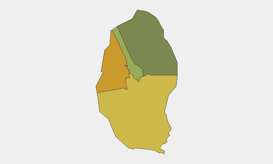
Bahrain remains a low-absolute-threat environment (rank #106 globally) but is experiencing indirect pressure from escalating Iran–UAE–GCC maritime and air tensions in the Strait of Hormuz. No major internal unrest, terrorism, or criminal incidents were recorded in the past 24–48 hours; however, a fatal residential fire (4 deaths, Al Ramli, 19 Aug) and partial aviation disruption signal underlying operational disruption. Northern and Southern Governorates carry elevated risk (72 and 68 respectively), driven by historical sectarian sensitivity and proximity to maritime conflict zones rather than active current unrest.
Key Developments
- Al Ramli Housing Complex residential fire (19 Aug): A building fire claimed the life of one adult and three children; Civil Defence responded and extinguished the blaze. Interior Ministry investigation is underway. No indication of sabotage or security-related cause reported.
- Bahrain Foreign Ministry condemnation of Iranian attack on UAE vessel (18 Aug): Bahrain's government issued a formal statement condemning an Iranian strike on an ADNOC-affiliated vessel transiting the Strait of Hormuz, reaffirming that UAE security is integral to Bahrain's own security framework.
- Merchant vessel strike in Strait of Hormuz (18–19 Aug): A projectile struck a commercial vessel transiting the strait, causing engine-room fire, structural damage, and at least one crew casualty. This event directly elevates maritime-security risk for Bahrain-bound and Bahrain-origin traffic.
- Regional ballistic-missile detection (19 Aug): UAE Defence Ministry reported detection and interception of two ballistic missiles launched from Iran toward UAE territorial waters. The UAE subsequently announced a halt to trade and financial transactions with Iran.
- UAE–Bahrain air connectivity disruption (19 Aug): Emirates resumed one daily Bahrain service; Etihad cancelled three pairs until 21 Aug; Air Arabia cancelled multiple UAE–Bahrain flights. flydubai continues operations, indicating partial but degraded connectivity.
- Political-detainee release from Jau Prison (18 Aug): 64 prisoners, including long-term political detainees, were temporarily released from Jau Prison—the first substantial release since the current regional conflict began. This move suggests limited easing of internal political-security pressure.
Highest-Risk Areas
Northern Governorate (risk 72) and Southern Governorate (risk 68) dominate sub-national risk; both retain elevated exposure to historical sectarian tensions and maritime-security spillover from the Strait of Hormuz and wider Gulf dynamics. Capital Governorate (risk 45), including Manama's Financial District, is now under a 12-hour daily curfew (16:00–04:00 local time) following 17 Aug security measures in Pearl Square—a significant but contained restriction. Muharraq Governorate (risk 38) poses lower composite risk.
How GeoBit Would Assist
Security teams operating in Bahrain should deploy Maritime & Aviation tracking to monitor Strait of Hormuz vessel movements and flight-schedule disruptions affecting personnel and asset mobility. AOI Monitoring & Early Warning on Northern and Southern Governorates, combined with OSINT fusion (social media, local news, political-detention reporting), would provide early signals of sectarian mobilization or spillover effects from regional conflict. Routing & Network Analysis can identify real-time alternative ground and air routes around the curfew zones and maritime hotspots.
7-Day Outlook
Regional Iran–GCC maritime tensions will likely persist; further vessel strikes or air incursions are possible, sustaining aviation and shipping disruption through late August. Internally, Bahrain's government appears to be managing sectarian pressure through selective detainee releases and localized curfews rather than broad crackdowns, suggesting stability but not normalization. Organizations should anticipate continued slow-moving travel delays and maintain heightened maritime-risk awareness for the next 5–7 days.
Highest-Risk Areas — Ranked
| # | State / Region | Risk |
|---|---|---|
| 1 | Northern Governorate | 72 |
| 2 | Southern Governorate | 68 |
| 3 | Capital Governorate | 45 |
| 4 | Muharraq Governorate | 38 |
Sources
Previous Daily Briefs
A new Bahrain brief is written every day — each with its own risk map and downloadable CSV. Here's the last week; use the calendar to go further back.
- August 17, 2026
- August 15, 2026
- August 13, 2026
- August 11, 2026
- August 9, 2026
- August 7, 2026
- August 6, 2026
📅 Browse every day by calendar →
Highlighted days have a brief. Tap a day for that day's map & analysis, or “csv” for that day's dataset ($5).
Atlas — our AI intelligence desk — emails them this snapshot personally. Nothing else, no list.