Situation Summary
Benin remains under sustained jihadist pressure in its northern departments, where armed groups affiliated with ISIS-West Africa and Al-Qaeda franchises have conducted attacks against military and civilian targets since late 2023. No discrete security incidents have been verified in the last 24–48 hours; however, the underlying threat posture—particularly in Alibori, Atakora, Donga, and Borgou departments—remains elevated and unchanged from recent weeks. Southern and central Benin continue to experience manageable baseline crime and civil order challenges with no active conflict.
Key Developments
No security incidents meet GeoBit's verification criteria (verifiable location + clear timestamp within last 24–48 hours) for Benin as of 3–4 August 2026. Recent regional media and open-source feeds contain no cross-confirmed new incidents in this window. Historical context: attacks on Beninese military near Kourou Koualou (Burkina Faso border) occurred on 25–26 May 2026 (over two months prior); a shooting incident in Tissèrou involving traditional hunters occurred on 26 July 2026 (approximately 8–9 days prior). Benin's political environment remains stable following the December 2025 coup attempt; no new governance or regime-stability events are reported in the current window.
Highest-Risk Areas
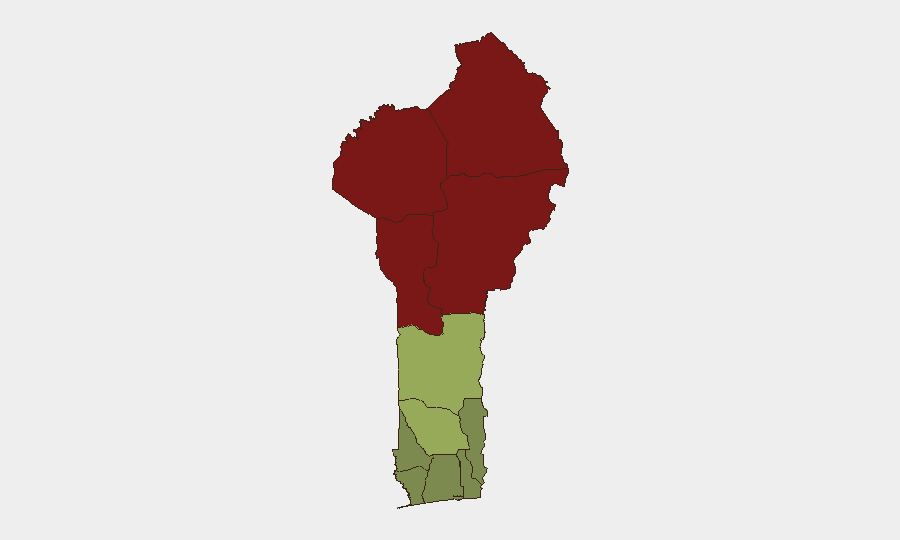
Northern Benin—particularly Alibori (risk 92), Atakora (88), Donga (85), and Borgou (83)—accounts for nearly all elevated composite risk. These four departments form a continuous band along Benin's border with Burkina Faso and Niger, where jihadist groups exploit weak state presence, cross-border safe havens, and rural terrain to stage ambushes and raids against military convoys and civilian populations. Zou (45) and Collines (42) show moderate risk, likely reflecting spillover criminal activity and community violence; the remaining southern and coastal departments (Ouémé, Littoral, Atlantique, Mono) register low to very low risk and remain suitable for normal business and expatriate residence with standard urban precautions.
How GeoBit Would Assist
Corporate security and duty-of-care teams operating in or traveling to Benin should deploy AOI (Area-of-Interest) Monitoring & Early Warning on Alibori, Atakora, and Donga departments to detect emerging attack patterns and force movements; simultaneously, Intel Sweep (global event feeds, multi-language OSINT, X/Twitter & Telegram monitoring) will flag new incidents within hours of occurrence. Conflict & Military analysis (force structure, weapons-capability tracking) and GIS & Spatial Analysis enable security teams to model alternative routing away from high-risk corridors and to brief travelers on checkpoint locations and recent activity clusters. Early Warning & Prediction analysis can flag seasonal or tactical shifts in jihadist operations (e.g., pre-election violence, resource competition with criminal actors).
7-Day Outlook
No acute catalyst or tactical shift is evident in the near term. Northern insecurity will likely remain episodic and confined to rural areas distant from major towns; military and cross-border smuggling operations continue to draw armed-group focus. Southern Benin should experience stable conditions. Security teams should maintain baseline vigilance in the north and prepare contingency communication and movement protocols for staff or assets in Alibori and Atakora.
Highest-Risk Areas — Ranked
| # | State / Region | Risk |
|---|---|---|
| 1 | Alibori Department | 92 |
| 2 | Atakora Department | 88 |
| 3 | Donga Department | 85 |
| 4 | Borgou Department | 83 |
| 5 | Zou Department | 45 |
| 6 | Collines Department | 42 |
| 7 | Plateau Department | 38 |
| 8 | Kouffo Department | 35 |
| 9 | Mono Department | 32 |
| 10 | Atlantique Department | 28 |
| 11 | Littoral | 25 |
| 12 | Ouémé Department | 22 |
Sources
Previous Daily Briefs
A new Benin brief is written every day — each with its own risk map and downloadable CSV. Here's the last week; use the calendar to go further back.
📅 Browse every day by calendar →
Highlighted days have a brief. Tap a day for that day's map & analysis, or “csv” for that day's dataset ($5).
Atlas — our AI intelligence desk — emails them this snapshot personally. Nothing else, no list.