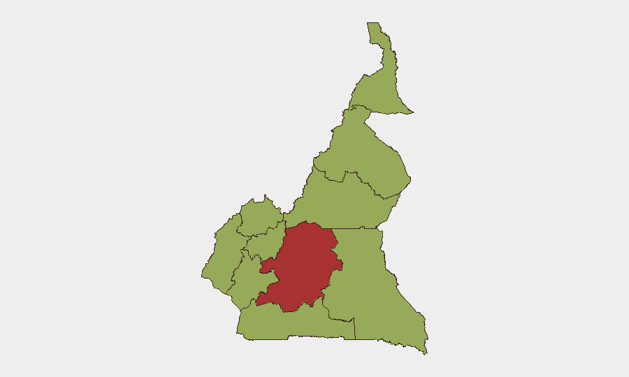
Situation Summary
Cameroon remains a moderately elevated risk environment (global rank #28, composite score 67) characterized by active Boko Haram operations in the Far North, ongoing Anglophone armed activity in the Northwest and Southwest, and residual civil unrest tied to the 2025 post-electoral crisis. The Centre region, dominated by Yaoundé and national institutions, carries the highest composite risk (77), reflecting political sensitivity and security-force concentration. Military operations against Boko Haram continue to generate civilian casualties and displacement, while armed kidnappings and extortion in the Anglophone corridor remain endemic. Trajectory is stable to slowly deteriorating, with no immediate sign of de-escalation in any sector.
Key Developments
- Far North Region (Tourou, Mokolo) – Night of 14–15 July 2026: Boko Haram militants attacked an advanced Cameroonian army post, killing at least one female civilian, wounding a 15-month-old infant by gunfire, and injuring four soldiers before being repelled. Cross-border incursion from Nigeria.
- Far North Region (Bargaram) – Night of 16–17 July 2026: Boko Haram fighters attacked a Rapid Intervention Battalion (BIR) post; Cameroonian counter-operation resulted in five militant deaths, one soldier killed, and seizure of weapons.
- Northwest Region (Bafoussam–Bamenda Road) – Late Saturday 18 July 2026, reported 19 July: Armed group intercepted a vehicle traveling between the West and Northwest regions, abducting seven passengers and subsequently demanding ransom from families. Incident attributed to Anglophone-crisis armed groups.
- West Region (Mbouda/Bafoussam Military Tribunal) – 15 July 2026: 46 detained protesters from post-electoral unrest appeared before military tribunal on charges including insurrection, property destruction, and unlawful assembly, signaling ongoing military-court processing of civil-disorder cases.
- National (Health Sector) – 20 July 2026: Ministry of Public Health and medical council jointly announced enforcement campaigns and judicial action against unlicensed clinics and beauty institutes, with reinforced inspections forthcoming. May affect urban security dynamics and travel logistics in major cities.
- Far North Region (Operational Posture) – Mid-July 2026 (ongoing): Aggregated threat intelligence confirms acute military stress across multiple fronts—active Boko Haram operations, cross-border engagements, and internal armed factions—with continued military mobilization and sporadic armed activity reinforcing elevated travel risk and infrastructure vulnerability.
Highest-Risk Areas
Centre region (score 77) is the primary driver of overall national risk, reflecting concentration of government institutions, security apparatus, and political sensitivity in Yaoundé. However, operational security threats are most acute in Far North (Boko Haram attacks, military operations, cross-border flux) and Northwest/Southwest (Anglophone armed groups, kidnapping, extortion). All remaining eight regions score identically at 47, suggesting distributed low-to-moderate baseline risk with localized flashpoints. Travel corridors linking these high-activity zones—particularly the Bafoussam–Bamenda road—present elevated kidnapping and armed-group encounter risk.
How GeoBit Would Assist
Security teams should employ AOI Monitoring & Early Warning on the Far North and Anglophone corridor to detect Boko Haram and armed-group activity in near-real time; Intel Sweep and X/Telegram OSINT to track ransom demands, hostage releases, and military statements; and Routing & Network Analysis to identify and update safe transit corridors for personnel or supply movements between high-risk regions. Conflict & Military force-structure tracking and satellite/imagery analysis provide situational awareness of military deployments and camp security posture.
7-Day Outlook
No major de-escalation is expected in the next seven days. Boko Haram operations in the Far North will likely remain episodic but persistent, with military counter-operations continuing to generate civilian risk. Anglophone armed groups are unlikely to reduce kidnapping activity absent negotiated settlement or significant security force concentration. Political tensions may intensify as military courts process detained protesters, but mass unrest is not forecast in the immediate term.
Highest-Risk Areas — Ranked
| # | State / Region | Risk |
|---|---|---|
| 1 | Centre | 77 |
| 2 | Northwest | 47 |
| 3 | Southwest | 47 |
| 4 | West | 47 |
| 5 | Littoral | 47 |
| 6 | Adamawa | 47 |
| 7 | South | 47 |
| 8 | Far-North | 47 |
| 9 | North | 47 |
| 10 | East | 47 |
Sources
Previous Daily Briefs
A new Cameroon brief is written every day — each with its own risk map and downloadable CSV. Here's the last week; use the calendar to go further back.
📅 Browse every day by calendar →
Highlighted days have a brief. Tap a day for that day's map & analysis, or “csv” for that day's dataset ($5).
Atlas — our AI intelligence desk — emails them this snapshot personally. Nothing else, no list.