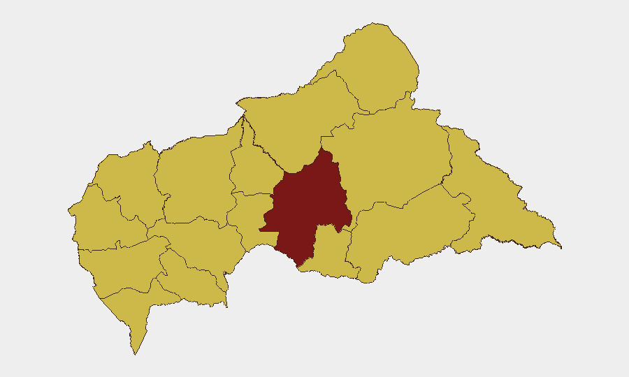
Situation Summary
Central African Republic remains a challenging operating environment, ranking #22 globally on GeoBit's composite threat index (score 91). The country is experiencing concurrent institutional friction—involving the Central Bank, commercial banking sector, and constitutional bodies—alongside persistent regional instability concentrated in the northeastern and eastern prefectures. The eastern border regions remain significantly more volatile than Bangui and the western corridor, with Ouaka prefecture alone accounting for a composite risk score nearly 50% higher than the national average.
Key Developments
- 2026-07-02 · Central Bank Administrative Sanctions. The Central Bank has initiated formal sanctions action; specific targets and remedial demands remain under investigation as of 2026-07-03.
- 2026-07-02 · Central Bank Public Statement (Population-Directed). Central Bank issued a statement addressing population concerns, indicating possible public-facing economic or monetary messaging related to institutional credibility.
- 2026-07-01 · Central Election Commission vs Constitutional Court (Disapproval). Institutional disagreement between election and constitutional authorities signals potential governance friction ahead of any planned electoral processes.
- 2026-07-01 · Central Bank vs Commercial Banking (Disapproval). Regulatory friction between the Central Bank and at least one commercial bank institution, suggesting possible compliance or solvency-related disputes.
- 2026-07-03 · Democratic Republic of Congo vs Nigeria (Disapproval). Cross-border interstate tension between DRC and Nigeria; trajectory and CAR implications remain under assessment.
*Note: Live web research on Central African Republic–specific incidents from the past 24–48 hours did not yield corroborated secondary sources beyond the GeoBit event signal feed. Teams requiring granular incident reporting (e.g., specific armed group activity, localised violence, or checkpoint/administrative changes) are encouraged to supply fresh regional news or social-media data for synthesis.*
Highest-Risk Areas
Ouaka prefecture (risk 63.6–93.6) is the single highest-risk location and warrants priority in any duty-of-care or asset-protection planning. A second-tier cluster of ten prefectures—spanning the northeastern (Bamingui-Bangoran, Vakaga, Haute-Kotto), eastern (Haut-Mbomou, Mbomou), and western (Nana-Mambéré, Ouham-Pendé, Mambéré-Kadéï) zones—all register composite scores of 63.6, indicating sustained instability across borders with Chad, Sudan, DRC, and Cameroon. The concentration of risk in the periphery suggests that Bangui and the western transport corridor remain relatively more stable, though institutional turbulence (Central Bank/banking sector friction) may introduce secondary risk to business operations and financial services in the capital.
How GeoBit Would Assist
Security and risk teams should employ AOI Monitoring & Early Warning to track Ouaka and the northeastern corridor for armed-group activity and checkpoint changes; Network & Actor Analysis to map Central Bank, commercial banking, and electoral stakeholders and their recent statements for early signals of institutional breakdown; and Routing & Network Analysis for real-time alternative-route planning if banking-sector instability or border volatility affects travel or supply chains. OSINT fusion (X/Twitter, Telegram, local radio SIGINT) provides 24–48 hour lead time on localised incidents before they escalate to corporate impact.
7-Day Outlook
Institutional tension between the Central Bank and commercial banking is unlikely to resolve quickly; monitoring for capital controls, banking suspensions, or further sanctions is warranted. Regional volatility in Ouaka and the east is expected to remain at current levels absent a sharp deterioration in cross-border activity. Teams should maintain heightened duty-of-care protocols in Bangui and the northeast and establish contingency communications with local partners and embassies.
Highest-Risk Areas — Ranked
| # | State / Region | Risk |
|---|---|---|
| 1 | Ouaka | 93.6 |
| 2 | Bamingui-Bangoran | 63.6 |
| 3 | Vakaga | 63.6 |
| 4 | Haute-Kotto | 63.6 |
| 5 | Haut-Mbomou | 63.6 |
| 6 | Mbomou | 63.6 |
| 7 | Nana-Mambéré | 63.6 |
| 8 | Ouham-Pendé | 63.6 |
| 9 | Mambéré-Kadéï | 63.6 |
| 10 | Sangha-Mbaéré | 63.6 |
| 11 | Ouham | 63.6 |
| 12 | Nana-Grébizi | 63.6 |
Sources
Previous Daily Briefs
A new Central African Republic brief is written every day — each with its own risk map and downloadable CSV. Here's the last week; use the calendar to go further back.
📅 Browse every day by calendar →
Highlighted days have a brief. Tap a day for that day's map & analysis, or “csv” for that day's dataset ($5).