Situation Summary
Croatia remains a low-threat environment with a composite national threat score of 4 and no verified large-scale civil unrest, terrorism, or political instability in the current 24–48-hour window. However, three discrete incidents—a toxic-gas detection near Rijeka, a fatal police shooting in Krapina, and ongoing anti-corruption operations in Split-Dalmatia—underscore localized safety and governance pressures. The country's stability trajectory is stable; risk is concentrated in border and post-conflict regions in the northeast and interior rather than in major urban or tourist zones.
Key Developments
- Kukuljanovo industrial zone (Rijeka), 28–29 July 2026: Public health authorities detected high and dangerous concentrations of hydrogen sulfide in the sewer system near the Orada Adriatic plant following citizen reports. Local police investigation underway; respiratory hazard risk for nearby workers and residents if concentrations persist.
- Krapina shopping center café, recent morning (late July/early August): A police officer—identified as the head of criminal police in Krapina—was shot and killed in a café. The shooter, reportedly a neighbor, subsequently shot himself. No indication of broader civil unrest or wider threat beyond localized interpersonal tension.
- Split-Dalmatia and Dubrovnik-Neretva counties, late July 2026: Anti-corruption unit PNUSKOK conducted ongoing arrests and searches linked to investigations involving former Split mayor Bruno Kerum. Operations may cause short-term disruptions around specific sites but do not indicate broad security deterioration.
- Split (Radunica neighborhood), evening 27 July 2026: Fire broke out in an abandoned building; 13 firefighters extinguished it in under one hour with no injuries. Illustrates occasional fire-safety concerns in derelict structures but poses no direct travel impact.
- Krapina-Zagorje County (multiple locations), past 24 hours: County police reported two road traffic accidents, four criminal offenses, one fire-safety violation (illegal waste burning in Poljanica Bistrička), and an assault on Zajčeva Street involving a minor. Routine low-level incident activity; no organized unrest indicated.
Highest-Risk Areas
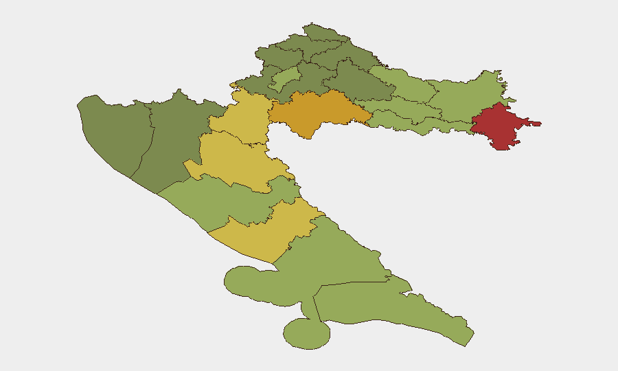
Vukovar-Srijem, Sisak-Moslavina, and Karlovac counties—all in the war-affected border and interior regions of eastern and central Croatia—drive the national composite risk score, scoring 78, 72, and 68 respectively. These areas experience residual tensions related to post-conflict recovery, infrastructure vulnerabilities, and demographic fragility. Zagreb and major coastal counties (Split-Dalmatia, Zadar) score substantially lower (50 and below), reflecting greater stability in urban centers and tourist regions. Organizations with personnel or assets in the northeast corridor should prioritize situational awareness; those in Zagreb, Split, Dubrovnik, and Zadar operate in lower-risk zones.
How GeoBit Would Assist
Security teams should use AOI Monitoring & Early Warning to track Vukovar-Srijem, Sisak-Moslavina, and Karlovac counties for escalation signals; OSINT fusion (social media, local news, and regional feeds) to detect emerging tensions or incidents in real time; and alternative route and network analysis to preplan evacuation or relocation pathways away from border zones. Environmental & health monitoring capabilities would provide early notification of infrastructure hazards such as the Rijeka gas incident.
7-Day Outlook
No material deterioration in national security posture is anticipated over the next seven days. Routine crime, administrative corruption investigations, and environmental incidents will likely persist at current baseline levels in regional areas. Organizations should maintain standard duty-of-care protocols, monitor local police and health authority advisories, and flag any acceleration in incidents in border counties as a trigger for deeper assessment.
Highest-Risk Areas — Ranked
| # | State / Region | Risk |
|---|---|---|
| 1 | Vukovar-Srijem County | 78 |
| 2 | Sisak-Moslavina County | 72 |
| 3 | Karlovac County | 68 |
| 4 | Lika-Senj County | 65 |
| 5 | Šibenik-Knin County | 62 |
| 6 | Brod-Posavina County | 58 |
| 7 | Zadar County | 55 |
| 8 | Osijek-Baranja County | 52 |
| 9 | City of Zagreb | 50 |
| 10 | Split-Dalmatia County | 48 |
| 11 | Požega-Slavonia County | 45 |
| 12 | Virovitica-Podravina County | 42 |
Sources
Previous Daily Briefs
A new Croatia brief is written every day — each with its own risk map and downloadable CSV. Here's the last week; use the calendar to go further back.
📅 Browse every day by calendar →
Highlighted days have a brief. Tap a day for that day's map & analysis, or “csv” for that day's dataset ($5).
Atlas — our AI intelligence desk — emails them this snapshot personally. Nothing else, no list.