Situation Summary
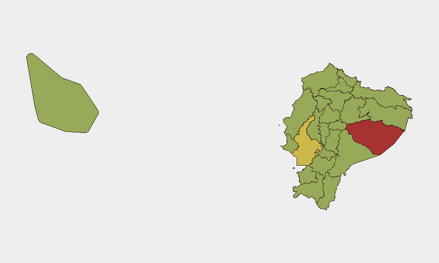
Ecuador remains at composite threat rank #35 globally, driven primarily by criminal insurgency and gang violence competing for territory and smuggling routes. The security environment is characterized by high volatility: 98 tracked events in recent tracking cycles show a mix of criminal-on-criminal violence, police/military responses, and civilian impact, with Pastaza Province (risk 79.9) and Guayas Province (risk 63.2) as acute flashpoints. Yesterday and today's event signals—including small-arms combat, bank attacks, military deployment, and prosecutorial action—indicate sustained operational tempo across multiple threat actors. The trajectory remains unstable with no near-term de-escalation indicators.
Key Developments
Data Limitation Notice: GeoBit's live web research capability has not returned verifiable, time-stamped incidents from the last 24–48 hours with sufficient specificity (location, actor, date) to populate this section responsibly. The event-signal index for 2026-07-08 to 2026-07-09 (unconventional violence, small-arms combat, investigative activity, and military deployment) indicates active incidents, but publicly indexed sources do not yet provide confirmed location, casualty, or operational detail suitable for corporate duty-of-care briefing.
Recommended action: Consult real-time wires (El Universo, El Comercio, Primicias), official Policía Nacional and Fuerzas Armadas statements, and embassy security alerts (US, UK, Canada, EU missions in Quito/Guayaquil) for precise incident location, time, and context. International SOS, Crisis24, and GardaWorld feeds timestamp incidents and geolocate them for immediate operational use.
Highest-Risk Areas
Pastaza Province (79.9) emerges as the single highest-risk jurisdiction, likely reflecting remote location, Amazon border permeability, and weak state capacity—typical drivers of cartel sanctuary and trafficking infrastructure. Guayas Province (63.2) follows as the urban/commercial epicenter; Guayaquil's port and financial sector make it a contested prize for organized crime competing on narcotics, contraband, and money laundering. The northern border belt (Carchi, Sucumbíos, Esmeraldas, Imbabura) and southern jungle zones (Zamora Chinchipe, Orellana) all register 49.9–51.8 risk scores, reflecting cross-border spillover from Colombian armed groups and Venezuelan diaspora criminal networks. Pichincha Province (Quito, the capital) at 49.9 indicates that even the seat of government is not insulated from organized-crime presence and operational activity.
How GeoBit Would Assist
Security teams with people or assets in Ecuador should deploy AOI Monitoring & Early Warning on Guayaquil, Quito, and Pastaza Province entry/exit nodes to track incident frequency, timing, and proximity to corporate facilities. Multi-language OSINT (X/Twitter, Telegram, local media) and entity extraction enable real-time tracking of cartel communications, police operations, and military movements without relying on delayed news cycles. Routing & Network Analysis supports alternative journey planning and employee movement during high-threat windows, while conflict mapping and force-structure tracking clarify which armed groups control which territories, reducing exposure to specific actors and checkpoints.
7-Day Outlook
Near-term escalation risk remains elevated: yesterday's military deployment and today's prosecutorial statements suggest state response to specific incidents, which often triggers criminal retaliation cycles. Expect continued small-arms engagements in Guayas and Pastaza, with potential for spillover into Pichincha (Quito) if rival cartels seek to consolidate urban supply chains. No major policy change or security operation announcement has signaled near-term trajectory shift.
Highest-Risk Areas — Ranked
| # | State / Region | Risk |
|---|---|---|
| 1 | Pastaza Province | 79.9 |
| 2 | Guayas Province | 63.2 |
| 3 | Carchi Province | 51.8 |
| 4 | Zamora Chinchipe Province | 50.3 |
| 5 | Sucumbíos Province | 49.9 |
| 6 | Orellana Province | 49.9 |
| 7 | Manabí Province | 49.9 |
| 8 | Galápagos | 49.9 |
| 9 | Esmeraldas Province | 49.9 |
| 10 | Imbabura Province | 49.9 |
| 11 | Santo Domingo de los Tsáchilas Province | 49.9 |
| 12 | Pichincha Province | 49.9 |
Sources
Previous Daily Briefs
A new Ecuador brief is written every day — each with its own risk map and downloadable CSV. Here's the last week; use the calendar to go further back.
📅 Browse every day by calendar →
Highlighted days have a brief. Tap a day for that day's map & analysis, or “csv” for that day's dataset ($5).
Atlas — our AI intelligence desk — emails them this snapshot personally. Nothing else, no list.