Situation Summary
Eritrea remains a low–frequency threat environment globally (rank #71, composite score 24), with no discrete security events recorded in the current tracking window. However, sub-national risk is heavily concentrated in the western and southern border zones, driven by proximity to active or residual conflict in Ethiopia's Tigray and ongoing tensions along the Sudanese frontier. The security picture is stable but volatile at the margins; corporate and NGO presence should remain alert to escalation in Gash-Barka and Southern Red Sea Region, where cross-border friction and limited state control create pockets of elevated exposure.
Key Developments
No discrete security incidents were confirmed in Eritrea during the last 24–48 hours.
Note on recent border activity: Intelligence and open-source feeds from 3–6 August 2026 documented claims of cross-border military activity and escalation rhetoric between Eritrean and Ethiopian forces, but these reports remain unverified and do not constitute confirmed events within the current brief window. A confirmed drone strike on Merewa Secondary School in Tigray, Ethiopia (not Eritrea) on or around 6 August 2026 underscores heightened military activity in the immediate border region and warrants monitoring for spillover risk.
Duty-of-care teams should treat the absence of recent incident reports as a stability signal rather than a guarantee, given Eritrea's restricted media environment and limited independent verification capacity.
Highest-Risk Areas
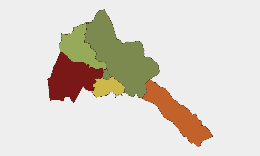
Gash-Barka (risk 92) and Southern Red Sea Region (risk 75) dominate the threat profile and account for the majority of elevated composite risk. Both regions share long, porous borders with Sudan and Ethiopia respectively—zones where state authority is diffuse, armed actors operate with relative impunity, and cross-border spillover from Tigray conflict dynamics remains a material concern. Debub Region (risk 68) presents secondary exposure, likely tied to proximity to Ethiopian disputed territory and residual lawlessness. By contrast, Maekel Region (the capital Asmara and immediate surroundings) remains the most secure zone (risk 18), reflecting central-state presence and urban infrastructure; Northern Red Sea Region shows minimal tracked risk but suffers from data scarcity and limited independent monitoring.
How GeoBit Would Assist
Corporate security teams monitoring Eritrea should leverage Area-of-Interest (AOI) Monitoring & Early Warning on Gash-Barka and Southern Red Sea Region to detect changes in military posture, cross-border movement, or armed-group activity before they escalate to incidents affecting personnel or supply chains. OSINT fusion and multi-language web/social-media intelligence (including X, Telegram, and YouTube) will help detect early warning signals from border communities and diaspora sources that precede formal incident reporting. Battle mapping and force-structure tracking linked to Ethiopia and Sudan border commands will provide tactical context for understanding Eritrean military readiness and likelihood of escalation.
7-Day Outlook
No imminent escalation is signaled by current data, but the August 3–6 cross-border activity claims and Tigray drone strikes suggest that regional tensions remain elevated. Organizations with personnel or assets in western and southern zones should maintain heightened situational awareness and pre-positioned contingency plans. A hardening or de-escalation in Eritrea–Ethiopia rhetoric over the next week would lower short-term operational risk; renewed military posturing or unverified reports of cross-border incursions would warrant immediate staff posture review.
Highest-Risk Areas — Ranked
| # | State / Region | Risk |
|---|---|---|
| 1 | Gash-Barka | 92 |
| 2 | Southern Red Sea Region | 75 |
| 3 | Debub Region | 68 |
| 4 | Anseba | 55 |
| 5 | Maekel Region | 18 |
| 6 | Northen Red Sea Region | 0 |
Sources
Previous Daily Briefs
A new Eritrea brief is written every day — each with its own risk map and downloadable CSV. Here's the last week; use the calendar to go further back.
📅 Browse every day by calendar →
Highlighted days have a brief. Tap a day for that day's map & analysis, or “csv” for that day's dataset ($5).
Atlas — our AI intelligence desk — emails them this snapshot personally. Nothing else, no list.