Situation Summary
France faces elevated acute risk from concurrent climate and geopolitical stressors as of 25 July 2026. A severe heatwave (the third since May) has triggered unprecedented wildfire activity across southwestern and southern regions, forcing mass evacuations, military mobilization, and strain on critical infrastructure and worker safety. Diplomatically, a detention and assault of French Embassy staff in Tehran has escalated diplomatic tensions and raised security risk to French diplomatic and expatriate personnel in Iran and sensitive regions.
Key Developments
- Saumos and Cap-Ferret peninsula, Gironde (Nouvelle-Aquitaine), 24 July: Interior Minister Laurent Nuñez confirmed a major wildfire has burned over 10,000 hectares with approximately 40,000 people evacuated or evacuating; roughly 80 houses reported burned (50 destroyed), 32 active fires nationwide, and French military, gendarmes, and firefighters mobilized with European air support requested.
- Southwest France coastal and rural areas (Nouvelle-Aquitaine), 24 July: Tens of thousands of residents and tourists displaced by "unprecedented" wildfires intensified by the third heatwave since May; major disruption to holiday travel and local infrastructure reported; President Macron mobilized military for fire suppression and evacuation operations.
- Pyrénées-Orientales and Hérault departments (southern France), 24 July: Active fires, ongoing evacuations, and local bans on fireworks introduced to reduce ignition risk in populated and tourist-heavy zones amid sustained heatwave conditions.
- Paris and major urban centres (nationwide), 24 July: Record number of departments placed under red heat alert; authorities implemented new public-order and health measures including restrictions on outdoor alcohol consumption and takeout alcohol sales to mitigate heat-related disorder and medical emergencies; outdoor worker safety protocols activated by platform operators (Uber Eats, Deliveroo) mandating breaks during severe heat.
- Tehran (diplomatic incident affecting France), night of 23–24 July: French Foreign Ministry confirmed detention of two locally employed staff at the French Embassy in Tehran, one of whom was physically assaulted during questioning; France summoned Iran's chargé d'affaires, condemned the act as "extremely serious intimidation" and violation of diplomatic immunity, escalating security risk to French diplomatic personnel and expatriates in the region.
Highest-Risk Areas
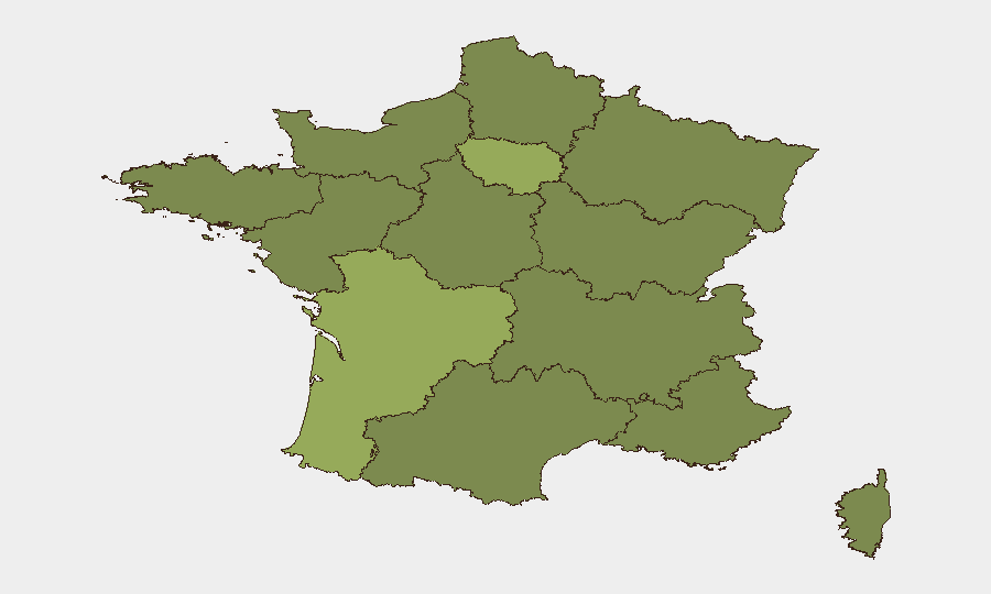
Île-de-France (risk 57.4) and Nouvelle-Aquitaine (risk 50.8) dominate the sub-national ranking. Île-de-France's elevation reflects Paris-centric governance, density, and national security infrastructure; Nouvelle-Aquitaine's score is now driven by the active wildfire crisis, mass evacuations, and strain on emergency services. Centre-Val de Loire, Normandy, and Provence-Alpes-Côte d'Azur follow at 30.3–29.1 and face secondary heatwave and fire risk. Corsica and Occitania, though lower-ranked, also report fire activity and heat stress.
How GeoBit Would Assist
Security teams should deploy AOI Monitoring & Early Warning on highest-risk regions (Nouvelle-Aquitaine, Pyrénées-Orientales, Hérault) to track active fire perimeters, evacuation zones, and infrastructure impacts in near-real time. Satellite & Imagery analysis coupled with GIS & Spatial Analysis enables asset and personnel location verification, route safety assessment, and supply-chain continuity planning across affected regions. Intel Sweep and multi-language OSINT provide continuous monitoring of Iranian state intent and French diplomatic incident escalation to support duty-of-care assessments for staff and operations in sensitive jurisdictions.
7-Day Outlook
Heatwave conditions are forecast to persist through late July, sustaining high fire risk in southwestern and southern regions; evacuation zones and emergency operations will likely remain in place or expand. Diplomatically, French-Iranian tensions will remain elevated; no immediate de-escalation signals are evident. Corporate continuity planning should assume extended disruption to Nouvelle-Aquitaine operations, leisure travel, and logistics networks, and heightened security protocols for France-Iran related personnel and assets.
Highest-Risk Areas — Ranked
| # | State / Region | Risk |
|---|---|---|
| 1 | Ile-de-France | 57.4 |
| 2 | Nouvelle-Aquitaine | 50.8 |
| 3 | Centre-Val de Loire | 30.3 |
| 4 | Normandy | 29.7 |
| 5 | Provence-Alpes-Côte d'Azur | 29.1 |
| 6 | Bourgogne – Franche-Comté | 29 |
| 7 | Hauts-de-France | 28.9 |
| 8 | Auvergne-Rhône-Alpes | 28.9 |
| 9 | Occitania | 27.8 |
| 10 | Grand Est | 27.7 |
| 11 | Pays de la Loire | 27.6 |
| 12 | Corsica | 27.6 |
Sources
Previous Daily Briefs
A new France brief is written every day — each with its own risk map and downloadable CSV. Here's the last week; use the calendar to go further back.
📅 Browse every day by calendar →
Highlighted days have a brief. Tap a day for that day's map & analysis, or “csv” for that day's dataset ($5).
Atlas — our AI intelligence desk — emails them this snapshot personally. Nothing else, no list.