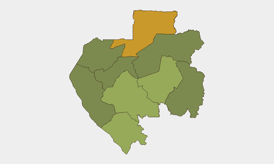
Situation Summary
Gabon remains a low-threat environment globally (#63, composite score 32) with no tracked discrete security events in the current reporting window. The country continues to experience routine public-administration and infrastructure incidents without signs of organized political violence, armed conflict, or terrorism. Near-term risk is concentrated in the remote northeastern and southeastern provinces, where governance capacity is weaker and cross-border mobility higher.
Key Developments
- Oyane 1 bridge (location unspecified) — night of September 21–22: A truck carrying timber fell from the bridge, killing its driver. The incident was reported by Info241; independent corroboration was not available within the reporting window.
- Louétsi River, Louétsi-Wano Department, Ngounié Province — September 21: The body of Émile Koudri Yao, a Togolese driver employed by EBOMAF Gabon, was recovered after he disappeared. Circumstances remain unclear; an investigation was opened by local gendarmes and authorities.
- Libreville — September 21–27: The Interior Ministry issued a formal notice to Reverend Jean-Daniel Allogo Essimengane regarding activities allegedly continuing despite a precautionary suspension of the Evangelical Church of Gabon. The dispute carried a potential public-order dimension and remained active through the week.
- Port-Gentil — reported September 23: Authorities conducted a clearance operation (*déguerpissement*) affecting more than 200 homes and businesses. Available reports did not specify whether the operation resulted in clashes, injuries, arrests, or significant disruption.
- Railway corridor, Gabon — reported September 24: SÉTRAG and local authorities announced strengthened cooperation on railway safety. The announcement noted three serious-person accidents recorded in 2026 to date, but specific locations and dates were not disclosed; these incidents cannot be disaggregated within the current reporting week.
Highest-Risk Areas
Woleu-Ntem Province (risk score 72) and Ogooué-Lolo Province (risk score 58) dominate the sub-national threat landscape, driven primarily by limited state presence, remote terrain, and cross-border mobility with Cameroon and Republic of the Congo. Ngounié Province (score 48) presents moderate risk linked to infrastructure and labor-related incidents, as evidenced by this week's recovery operation. Conversely, Estuaire Province (Libreville and immediate surroundings) and Ogooué-Ivindo (score 0) register substantially lower risk and reflect stronger security apparatus and administrative capacity in coastal and central zones.
How GeoBit Would Assist
Corporate security and duty-of-care teams should employ AOI Monitoring & Early Warning to track personnel and asset movements in high-risk provinces (Woleu-Ntem, Ogooué-Lolo), enabling real-time alerting if incidents or unrest emerge near operations. Routing & Network Analysis supports safety planning for overland and maritime logistics, particularly in Ngounié and border-adjacent regions. OSINT Fusion & Corroboration across local media, government announcements, and regional intelligence would strengthen real-time incident verification and reduce reliance on single-source reports.
7-Day Outlook
No escalation in national-level security is anticipated over the coming week. Routine administrative frictions (clearances, religious disputes) and isolated traffic/labor incidents will likely continue at current frequency. Teams should maintain standard duty-of-care protocols for remote-province operations and monitor local media for early signs of labor unrest or administrative disruptions affecting transport corridors.
Highest-Risk Areas — Ranked
| # | State / Region | Risk |
|---|---|---|
| 1 | Woleu-Ntem | 72 |
| 2 | Ogooué-Lolo Province | 58 |
| 3 | Ngounié Province | 48 |
| 4 | Nyanga Province | 42 |
| 5 | Haut-Ogooué Province | 35 |
| 6 | Moyen-Ogooué Province | 28 |
| 7 | Ogooué-Maritime Province | 25 |
| 8 | Estuaire Province | 15 |
| 9 | Ogooué-Ivindo | 0 |
Sources
Previous Weekly Briefs
A new Gabon brief is written every Monday, covering the week — each with its own risk map and downloadable CSV. Use the calendar to go further back.
- September 21, 2026
- September 14, 2026
- September 7, 2026
- September 1, 2026
- August 30, 2026
- August 28, 2026
- August 25, 2026
📅 Browse past briefs by calendar →
Highlighted days have a brief. Tap a day for that day's map & analysis, or “csv” for that day's dataset ($5).
Atlas — our AI intelligence desk — emails them this snapshot personally. Nothing else, no list.