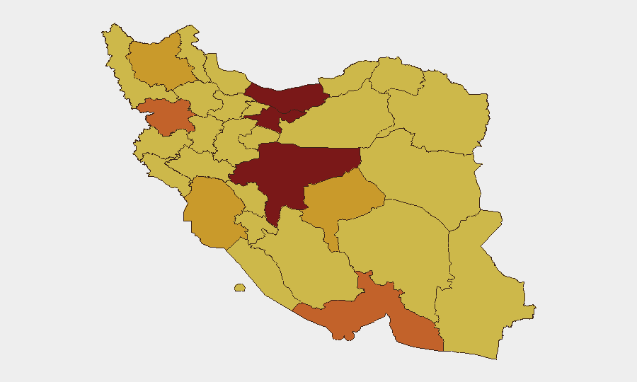
Situation Summary
Iran remains the world's highest-threat environment, driven by active military conflict with the United States centered on the Strait of Hormuz and broader regional instability. A fragile 60-day ceasefire, agreed June 29 after tit-for-tat airstrikes, is already showing signs of strain, with fresh vessel attacks and Iranian rejection of permanent peace terms signaling continued escalation risk. Tehran Province and southern coastal regions (Hormozgan, Khuzestan) face the most immediate military and maritime threat, while political uncertainty regarding the durability of any interim agreement underscores operational hazard across all Iranian territory.
Key Developments
- Strait of Hormuz / Southern Coast – June 26–27: U.S. conducted airstrikes on approximately ten Iranian military targets, including missile storage, drone facilities, and coastal radar installations following a tanker attack in the strait. CENTCOM confirmed the action.
- Strait of Hormuz – June 27–29: Iran launched missiles and drones at U.S. military sites in Kuwait and Bahrain in response, expanding the theater of direct military engagement beyond Iranian borders and triggering the halt-attacks agreement.
- Doha, Qatar – June 30: U.S. and Iranian delegations are resuming technical negotiations on implementing a memorandum of understanding regarding Strait of Hormuz transit, Iran's nuclear posture, and regional security issues.
- Iran (National Level) – June 29–30: Iranian authorities publicly rejected the latest ceasefire proposal, demanding permanent cessation of conflict rather than a temporary halt. This rejection occurred even as U.S. retaliation threats remained active.
- Maritime Traffic / Strait of Hormuz – June 25–30: Commercial vessels continue to report strikes by projectiles in the strait; the ceasefire permits vessels to move "freely" under interim terms, but the precarious security environment persists.
Highest-Risk Areas
Tehran Province (risk 100) and southern maritime provinces—Hormozgan (74.9) and Khuzestan (71.1)—drive overall threat levels due to their proximity to U.S. military operations and critical energy infrastructure around the Strait of Hormuz. Isfahan Province (92.5) ranks second nationally, suggesting risk concentration in Iran's central and southern regions tied to military installations and strategic economic corridors. Kurdistan and East Azerbaijan provinces (both ~71) reflect border-area vulnerability tied to cross-border militant activity and regional proxy dynamics. Northern coastal regions (Mazandaran, Gilan) show elevated but slightly lower risk, indicating secondary exposure to maritime and cross-border spillover rather than primary combat zones.
How GeoBit Would Assist
Security teams should deploy AOI Monitoring & Early Warning on Tehran, Hormozgan, and Khuzestan provinces to detect renewed military activity or ceasefire violations in near-real time. Maritime & Aviation tracking combined with Satellite & Imagery analysis enable continuous monitoring of vessel movements, military redeployments, and infrastructure damage in the Strait and coastal zones. Early Warning & Prediction capabilities, fed by Intel Sweep (global event feeds, social and broadcast OSINT), provide advance signals of political statements, military posturing, or proxy action that typically precede escalation or policy shifts.
7-Day Outlook
The Doha negotiations will be the critical inflection point; if talks stall or break within 48–72 hours, renewed military strikes and expanded targeting are probable. Iranian rejection of permanent peace terms combined with continued vessel attacks suggests the ceasefire is transitional rather than stable. Corporate teams with personnel or assets in Tehran, Isfahan, or southern coast regions should assume heightened security posture and contingency readiness through at least early July.
Highest-Risk Areas — Ranked
| # | State / Region | Risk |
|---|---|---|
| 1 | Tehran Province | 100 |
| 2 | Isfahan Province | 92.5 |
| 3 | Mazandaran Province | 80.2 |
| 4 | Hormozgan Province | 74.9 |
| 5 | Kurdistan Province | 73.4 |
| 6 | Yazd Province | 71.9 |
| 7 | Khuzestan Province | 71.1 |
| 8 | East Azerbaijan Province | 71.1 |
| 9 | Razavi Khorasan | 70.8 |
| 10 | Ilam Province | 70.4 |
| 11 | Kohgiluye and Buyer Ahmad Province | 70.4 |
| 12 | Gilan Province | 70.4 |
Sources
Previous Daily Briefs
A new Iran brief is written every day — each with its own risk map and downloadable CSV. Here's the last week; use the calendar to go further back.
📅 Browse every day by calendar →
Highlighted days have a brief. Tap a day for that day's map & analysis, or “csv” for that day's dataset ($5).