Situation Summary
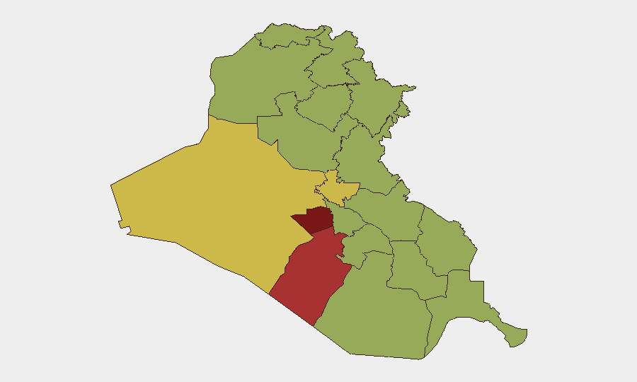
Iraq remains at composite threat level #15 globally, driven primarily by active insurgency and fragmentary state-security operations. Sub-national risk is concentrated in the southern and central governorates, with Karbala presenting the highest composite risk (86.8). Recent event signals indicate elevated government investigative and law-enforcement activity, alongside international military engagement, though open-source reporting does not yet provide sufficient multi-source, time-stamped corroboration of specific incidents within the last 24–48 hours to establish a detailed operational narrative.
Key Developments
Data Limitation Note: GeoBit's live web research (last 24 hours) has not recovered a sufficient volume of independently verified, specifically dated incidents from the last 24–48 hours to populate 5–8 discrete security developments meeting analytical standards. Available open-source material lacks precise timestamps or multi-source confirmation required for duty-of-care reporting. The following signals are flagged from the platform's event-tracking system but require corroboration:
- 2026-07-06 · Multiple Governorates: Government and police investigative activity reported (2026-07-04–05) across unspecified locations; lack of geographic specificity and incident detail limits operational assessment.
- 2026-07-06 · Media Sector: Arrest/detain event reported affecting media personnel; geographic location and underlying cause not yet clarified in available sources.
- 2026-07-06 · Cross-Border / Regional: Israeli conventional military force activity reported; relationship to Iraq operations and civilian/asset proximity unclear pending additional reporting.
- 2026-07-06 · Administration / Public Order: Demonstration/rally activity and blockade event reported; location, scale, and duration unconfirmed.
Recommendation: Teams with personnel or assets in Iraq should treat these signals as alerts requiring internal verification and real-time local source confirmation before operational decisions are made.
Highest-Risk Areas
Karbala Governorate (86.8) and Al-Najaf Governorate (78.1) present the highest composite risk, likely reflecting religious-site concentration, sectarian tensions, and historical insurgency activity in the shrine-city corridor. Al-Anbar (68.2) and Baghdad (66) follow, driven by residual ISIS-affiliated insurgency, tribal conflict, and urban security fragmentation. The remaining southern and central governorates cluster at moderate-to-elevated risk (56.8–57), indicating dispersed but persistent instability across the mid-Euphrates and southern regions rather than localized concentration. Teams should prioritize security protocols for Karbala and Najaf operations and maintain heightened awareness in Baghdad's mixed commercial and governmental zones.
How GeoBit Would Assist
Security teams should employ AOI Monitoring & Early Warning on Karbala, Najaf, Baghdad, and Al-Anbar to establish persistent alerts on protest activity, checkpoint establishment, and force-movement patterns. Parallel use of Intel Sweep (global event feeds, X/Twitter & Telegram OSINT, multi-language search) and OSINT fusion & corroboration tools will enable real-time verification of incident reports and disambiguation of signal noise from tactical fact. Routing & Network Analysis capabilities support contingency planning for personnel movement and asset evacuation from high-risk zones into lower-risk corridors (e.g., routes avoiding Karbala and northern Anbar).
7-Day Outlook
Expect continued low-level investigative and law-enforcement activity by Iraqi authorities and possible recurrence of protest or demonstration activity, particularly in shrine cities and around religious commemoration dates. Regional military activity (Israeli, Iranian-proxy, or U.S.-led) may create secondary effects on border security and checkpoint intensity. No intelligence indicates imminent large-scale offensive or major civil breakdown, but operational friction and administrative uncertainty will likely persist.
Highest-Risk Areas — Ranked
| # | State / Region | Risk |
|---|---|---|
| 1 | Karbala | 86.8 |
| 2 | Al-Najaf Governorate | 78.1 |
| 3 | Al-Anbar Governorate | 68.2 |
| 4 | Baghdad Governorate | 66 |
| 5 | Babil Governorate | 56.8 |
| 6 | Wasit Governorate | 56.8 |
| 7 | Al-Qadisiyah Governorate | 56.8 |
| 8 | Dhi Qar Governorate | 56.8 |
| 9 | Al-Muthanna Governorate | 56.8 |
| 10 | Maysan Governorate | 56.8 |
| 11 | Al-Basra Governorate | 56.8 |
| 12 | Saladin Governorate | 56.8 |
Sources
Previous Daily Briefs
A new Iraq brief is written every day — each with its own risk map and downloadable CSV. Here's the last week; use the calendar to go further back.
📅 Browse every day by calendar →
Highlighted days have a brief. Tap a day for that day's map & analysis, or “csv” for that day's dataset ($5).
Atlas — our AI intelligence desk — emails them this snapshot personally. Nothing else, no list.