Situation Summary
Israel remains at threat level #2 globally (composite score 100), driven by active conventional military operations and 406 tracked security events. The past 48 hours have seen renewed focus on Gaza border infrastructure volatility, West Bank settlement expansion, and persistent cross-border friction with Lebanon and Iranian actors. The threat environment combines kinetic military activity, policy escalation, and humanitarian-access friction at critical chokepoints, with secondary risk of civil unrest in mixed urban zones.
Key Developments
- Rafah aid distribution incident, Gaza–Israel border (July 9, early hours): ICRC and BBC confirm at least 21 killed and dozens shot during aid queue near Rafah crossing. While geographically in Gaza, incident directly implicates Israeli-controlled border crossing security and humanitarian infrastructure risk for personnel transiting or working near southern border zones.
- West Bank settlement expansion announcement (July 8–9): Israeli government announced largest settlement expansion in years across occupied West Bank. Palestinian Authority condemned move as "dangerous escalation." Development elevates civil-unrest and protest risk in settlement flashpoint areas and key West Bank transit corridors used by international personnel and contractors.
- East Jerusalem policing incident (July 6; operationally current): Israeli Border Police officer filmed deploying stun grenade into vehicle with Palestinians trapped inside. Incident is driving heightened social-media debate and sentiment in mixed East Jerusalem neighborhoods, signaling elevated urban tension and spontaneous protest risk in Jerusalem District.
- Lebanon–Israel cross-border strikes (late June–early July context): BBC notes recent reciprocal strikes across northern frontier following framework agreement, with confirmed fatality. Specific incidents within last 24 hours not clearly documented in open feeds, but volatility persists as operational backdrop for North District.
- Iran–Israel conventional military activity (July 8): Tracked event signal indicates ongoing Iranian military posturing or activity directed at Israeli targets. No specific incident details available in public OSINT, but reflects sustained escalation risk from regional state actors.
Highest-Risk Areas
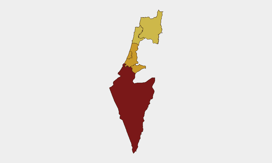
South District (risk 100) dominates the risk matrix, driven by active military operations in Gaza, border-crossing volatility, and humanitarian-access friction. Tel-Aviv, Center, Jerusalem, Haifa, and North Districts (risk 70–72) form a secondary tier reflecting urban civil-unrest potential, settlement-policy backlash, cross-border military activity from Lebanon, and police-conduct friction in mixed neighborhoods. Settlement expansion and Gaza border incidents are primary drivers of South and Center District elevation; northern border friction sustains North District risk. Jerusalem District's mixed demographics and recent policing incidents elevate urban-instability risk.
How GeoBit Would Assist
Security teams should deploy AOI (Area-of-Interest) Monitoring & Early Warning on South District border crossings, West Bank settlement flashpoint zones, and North District Lebanon frontier to catch tactical incidents before they escalate to operational level. Multi-language OSINT (X, Telegram, YouTube sentiment analysis) and entity extraction on Palestinian, Israeli, and Lebanese actor networks will provide leading indicators of protest mobilization and incitement in response to settlement policy and policing incidents. Routing & Network Analysis can identify secure transit alternatives around high-tension West Bank and Jerusalem zones in real time.
7-Day Outlook
Settlement expansion and Gaza border friction will likely sustain elevated civil-unrest risk in South, Center, and Jerusalem Districts over the next week, with secondary risk of spontaneous protests in Tel-Aviv and mixed neighborhoods. Lebanon border activity and Iranian military signaling suggest persistent kinetic risk in the North. No clear de-escalation triggers visible in the current policy trajectory.
Highest-Risk Areas — Ranked
| # | State / Region | Risk |
|---|---|---|
| 1 | South District | 100 |
| 2 | Tel-Aviv District | 72.3 |
| 3 | Center District | 71 |
| 4 | Jerusalem District | 71 |
| 5 | Haifa District | 70.1 |
| 6 | North District | 70.1 |
Previous Daily Briefs
A new Israel brief is written every day — each with its own risk map and downloadable CSV. Here's the last week; use the calendar to go further back.
📅 Browse every day by calendar →
Highlighted days have a brief. Tap a day for that day's map & analysis, or “csv” for that day's dataset ($5).
Atlas — our AI intelligence desk — emails them this snapshot personally. Nothing else, no list.