Situation Summary
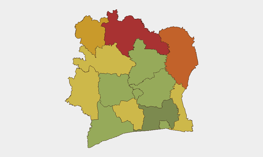
Ivory Coast remains a stable middle-income country globally (#60 in composite threat ranking) with 0 tracked security events in the current assessment period. However, sub-national risk is heavily concentrated in the north and northeast—Savanes, Zanzan, and Denguélé districts carry scores of 72–78, driven by cross-border criminal activity, illegal mining tensions, and armed robbery. Recent weeks have seen isolated incidents of impersonation crime, gendarmerie enforcement clashes, and infrastructure theft, but no widespread unrest or organized armed activity. The security environment is fragmented rather than systemic; risk is location-specific rather than national.
Key Developments
No confirmed security or civil unrest incidents were identified in Ivory Coast during the last 24–48 hours (31 August – 1 September 2026). Open-source intelligence sweeps returned no clearly dated events meeting the recency threshold for domestic Ivory Coast security, crime, or political instability in this window.
Recent context (prior week, provided for situational awareness):
- 2026-08-30, Tanda region (Worodougou): Three suspects impersonating Police Nationale and FDS officers assaulted civilians and stole 75,000 CFA francs; part of an ongoing pattern of false-authority robbery.
- 2026-08-25, location unspecified: Local populations protested gendarmerie anti-illegal-mining enforcement operations, creating tensions between residents and security forces.
- 2026-08-24, Tanda–Bodana border area: Gunfire heard ~800 m from Ivorian border post, originating from or near Bodana (Burkina Faso side); origin and intent unclear.
- 2026-08-23, location unspecified: Armed robbery of an under-construction prefecture; electrical wiring valued ~150 million FCFA stolen; assessed as part of wider infrastructure-theft pattern.
These incidents underscore petty to mid-level criminality and localized enforcement tensions rather than organized instability.
Highest-Risk Areas
The northern and northeastern border districts—Savanes, Zanzan, and Denguélé—drive the country's composite risk profile. All three score above 72 and reflect chronic cross-border smuggling, illegal artisanal mining (particularly gold), and weak state capacity enforcement. Comoé and Montagnes districts (scores 70 and 68) extend this risk corridor eastward and upward. These regions are remote, sparsely administered, and proximate to Burkina Faso and Mali, where militant and criminal networks operate; Ivory Coast's gendarmerie anti-mining sweeps and border patrols trigger community resistance and create flashpoints. Abidjan, by contrast, scores only 45 (lowest on the ranked list), reflecting stable urban governance and police presence, though petty crime and organized theft remain endemic.
Risk concentration in the north is not declining; enforcement operations and resource competition are likely to sustain tension through Q4 2026.
How GeoBit Would Assist
Security and risk teams with personnel or assets in Ivory Coast should deploy AOI (Area-of-Interest) Monitoring & Early Warning on Savanes, Zanzan, and Denguélé districts to track criminal activity, gendarmerie operations, and cross-border incident signals in near-real time. Multi-language OSINT (social media, local news wires, Telegram/X feeds) and entity extraction would surface emerging robbery networks, illegal mining disputes, and impersonation crime cells before they affect corporate operations. Routing & Network Analysis capabilities enable security teams to identify and plan alternative travel corridors around high-risk zones, especially in the northwest. Satellite and GIS spatial analysis can correlate gendarmerie enforcement patrols with incident hotspots to predict tension zones.
7-Day Outlook
No acute crisis is anticipated over the next 7 days. Localized crime and enforcement friction in the north are likely to continue at current levels. If opposition political activity (last noted 26 August) resumes large-scale protests in Abidjan, monitoring of protest routes and security-force posture would be warranted, though no imminent mobilization is signaled. Risk trajectory remains stable but fragmented.
Highest-Risk Areas — Ranked
| # | State / Region | Risk |
|---|---|---|
| 1 | Savanes District | 78 |
| 2 | Zanzan District | 75 |
| 3 | Denguélé District | 72 |
| 4 | Comoé District | 70 |
| 5 | Montagnes District | 68 |
| 6 | Woroba District | 65 |
| 7 | Gôh-Djiboua District | 60 |
| 8 | Sassandra-Marahoué District | 58 |
| 9 | Vallée du Bandama District | 55 |
| 10 | Bas-Sassandra District | 52 |
| 11 | Lacs District | 48 |
| 12 | Abidjan | 45 |
Sources
Previous Daily Briefs
A new Ivory Coast brief is written every day — each with its own risk map and downloadable CSV. Here's the last week; use the calendar to go further back.
- August 31, 2026
- August 30, 2026
- August 28, 2026
- August 26, 2026
- August 25, 2026
- August 23, 2026
- August 21, 2026
📅 Browse every day by calendar →
Highlighted days have a brief. Tap a day for that day's map & analysis, or “csv” for that day's dataset ($5).
Atlas — our AI intelligence desk — emails them this snapshot personally. Nothing else, no list.