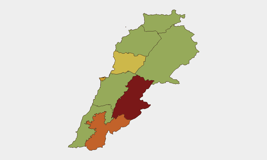
Situation Summary
Lebanon remains in a precarious security state (composite threat score 82/100, #19 globally) with acute escalation in southern border regions as of 9–10 July 2026. Israeli military operations—including drone strikes, artillery shelling, and ground demolitions—are occurring across multiple districts in Nabatieh and the Marjayoun area, resulting in confirmed civilian casualties and structural damage. The pattern suggests deteriorating adherence to recent ceasefire terms and rising risk of wider cross-border conflict, with domestic political instability (assassination, institutional disapproval signals) compounding the external threat.
Key Developments
- Nabatie al-Fqa, Nabatieh Governorate (9 Jul): Israeli drone strike killed four civilians—a school headteacher, her mother, a foreign domestic worker, and a Syrian laborer—near their family home. IDF stated the vehicle had entered a security zone and posed a threat.
- Haddatha, Bint Jbeil District (10 Jul, morning): Two Israeli bombing strikes reported; described as part of ongoing border field escalation in southern Lebanon.
- Houla, Marjayoun District (10 Jul, morning): Israeli strikes involving artillery or explosive impacts recorded in and around the town.
- Taybeh and Khiam, Marjayoun District (10 Jul, early morning): Israeli forces conducted explosive demolitions in both locations, with multiple reports of blasts and structural damage as part of coordinated southern escalation.
- Ali al-Taher heights, eastern southern sector (9 Jul): Lebanese security sources reported Israeli settlers, under military protection, crossed into southern Lebanon; Israeli drone raised an Israeli flag on the eastern side of the heights—framed by Lebanese media as ceasefire violation and sovereignty breach.
- Border shelling (9–10 Jul): Lebanon's National News Agency documented Israeli artillery shelling across multiple southern border areas during the first 10 days of the ceasefire period, with ongoing fire noted through 10 July; casualties in the dozens reported.
- Domestic political friction (8–9 Jul): Events flagged include assassination, institutional disapproval (Army, Ministry), and Amnesty International criticism of both Israel and Lebanon, indicating internal governance strain alongside external threat.
Highest-Risk Areas
Beqaa Governorate (87.5) and Nabatieh Governorate (73.6) are the primary risk drivers, with Beirut (72.4) following closely. The southern governorates—Nabatieh, South, and the Marjayoun districts—are experiencing active cross-border military operations, civilian casualties, and structural destruction. Beqaa's elevated score reflects its historical role as a transit and staging corridor for non-state actors and weapons flows. Beirut's rank reflects concentration of government institutions, foreign missions, and civilian density, amplifying impact of any escalation or internal instability.
How GeoBit Would Assist
Teams managing personnel or assets in Lebanon should employ AOI Monitoring & Early Warning (persistent watch on southern border districts, Beqaa, and Beirut with real-time alerting), Satellite & Imagery Analysis (damage assessment and force-positioning confirmation in Marjayoun and Nabatieh), and Conflict & Military (battle mapping and weapons-capability tracking to anticipate escalation patterns). Routing & Network Analysis supports contingency evacuation planning by identifying safer corridors away from active strike zones. Intelligence fusion via OSINT (X/Telegram, regional news wires, YouTube) and multi-language search provides early detection of ceasefire violations and political shifts driving domestic instability.
7-Day Outlook
Cross-border military operations are likely to persist or intensify through mid-July, with Israeli strikes targeting southern border towns and Hezbollah-aligned infrastructure. Domestic political friction (institutional disapproval, assassination signals) may hinder Lebanese state response capacity and increase risk of uncontrolled escalation. Civilian exposure in Nabatieh, South Governorate, and Beqaa remains elevated; organizations should maintain contingency postures and monitor developments through 15 July minimum.
Highest-Risk Areas — Ranked
| # | State / Region | Risk |
|---|---|---|
| 1 | Beqaa Governorate | 87.5 |
| 2 | Nabatieh Governorate | 73.6 |
| 3 | Beirut Governorate | 72.4 |
| 4 | Keserwan-Jbeil Governorate | 68.7 |
| 5 | North Governorate | 57.5 |
| 6 | Akkar Governorate | 57.5 |
| 7 | Mount Lebanon Governorate | 57.5 |
| 8 | South Governorate | 57.5 |
| 9 | Baalbek-Hermel Governorate | 57.5 |
Sources
Previous Daily Briefs
A new Lebanon brief is written every day — each with its own risk map and downloadable CSV. Here's the last week; use the calendar to go further back.
📅 Browse every day by calendar →
Highlighted days have a brief. Tap a day for that day's map & analysis, or “csv” for that day's dataset ($5).
Atlas — our AI intelligence desk — emails them this snapshot personally. Nothing else, no list.