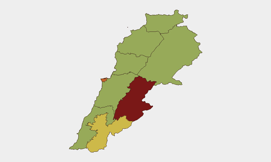
Situation Summary
Lebanon remains at elevated risk (composite threat score 76, #21 globally) amid active cross-border hostilities with Israel, ongoing political negotiations over territorial withdrawal, and continued military mobilization by regional actors. The past 48 hours have seen intensified Israeli strikes in the south, arrival of a US military delegation to negotiate security arrangements for pilot-zone withdrawals, and tightened airport security. While diplomatic engagement signals de-escalatory intent, the frequency and proximity of recent strikes to civilian areas, combined with unresolved territorial control issues, sustain a trajectory of high near-term volatility.
Key Developments
- Beirut, 11 July – US military delegation arrived and began talks with Lebanese officials on the framework for Israeli withdrawal from designated "pilot zones" in southern Lebanon, including formation of security management committees and operational plans for force replacement.
- Southern Lebanon border areas, 11–12 July – IDF conducted strikes on four reported "terror cells" along the frontier; cumulative recent strikes in southern governorates have killed at least 47 people and wounded nearly 100, with operations concentrated near the Blue Line.
- Southern Lebanon, 11–12 July – Spike in IDF air and artillery activity observed along the southern frontier, targeting launch sites and suspected Hezbollah positions; exact village-level impact not fully disclosed but operations focused near border districts including Marjayoun and Bint Jbeil.
- Beirut, 11 July – Lebanese and Qatar Airlines implemented new security measures at Beirut–Rafic Hariri International Airport, including prohibitions on passengers carrying pagers and walkie-talkies, reflecting heightened security posture in response to regional conflict environment.
- Lebanon (national), 11–12 July – Re-circulation of Amnesty International's report on March 2026 civilian casualties in Tyre, Saida, and Nabatieh driving renewed international and domestic pressure for war-crimes investigations; contributes to current political tension and protest mobilization on social platforms.
- Lebanon (national), 12 July – Population-level public statements and resident commentary documented across social feeds, reflecting heightened civilian awareness of escalation risk and negotiation stakes.
Highest-Risk Areas
Beqaa Governorate (83.3) and Beirut Governorate (73.3) anchor the risk ranking, driven by sustained cross-border military activity, Israeli strike frequency, and political sensitivity around negotiations and civilian protection. Nabatieh Governorate (69.7) reflects intensive southern border operations and cumulative casualties. The remaining governorates cluster at moderate-to-elevated risk (53–54), indicating that while the south and capital dominate immediate threat concentration, instability pressures extend across northern, eastern, and coastal regions where Hezbollah, military, and Iranian-linked mobilization contribute to secondary conflict risk.
How GeoBit Would Assist
Security teams should deploy AOI Monitoring & Early Warning on high-risk sub-national zones (Beqaa, Beirut, Nabatieh, and border districts) to ingest real-time cross-border strike patterns and military movements. OSINT fusion (X/Twitter, Telegram, regional media) combined with conflict & military force tracking provides continuous visibility on Israeli operations, Lebanese military posture, and Hezbollah positioning. Routing & Network Analysis supports secure travel planning for personnel in Beirut and southern regions by identifying safer alternative routes away from Blue Line proximity and areas of recent strike concentration.
7-Day Outlook
Negotiations on pilot-zone security arrangements will likely continue, but Israeli strike operations are expected to persist as a pressure tactic and counter-Hezbollah measure. Airport security measures and travel restrictions will remain in effect. Risk of unintended escalation—via a strike near civilian concentrations, a failed negotiation milestone, or cross-border incident—remains material over the next 7 days, particularly in southern Beirut and Nabatieh Governorate.
Highest-Risk Areas — Ranked
| # | State / Region | Risk |
|---|---|---|
| 1 | Beqaa Governorate | 83.3 |
| 2 | Beirut Governorate | 73.3 |
| 3 | Nabatieh Governorate | 69.7 |
| 4 | Keserwan-Jbeil Governorate | 53.6 |
| 5 | North Governorate | 53.3 |
| 6 | Akkar Governorate | 53.3 |
| 7 | Mount Lebanon Governorate | 53.3 |
| 8 | South Governorate | 53.3 |
| 9 | Baalbek-Hermel Governorate | 53.3 |
Sources
Previous Daily Briefs
A new Lebanon brief is written every day — each with its own risk map and downloadable CSV. Here's the last week; use the calendar to go further back.
📅 Browse every day by calendar →
Highlighted days have a brief. Tap a day for that day's map & analysis, or “csv” for that day's dataset ($5).
Atlas — our AI intelligence desk — emails them this snapshot personally. Nothing else, no list.