Situation Summary
Lebanon remains in a fragile post-ceasefire state marked by continued cross-border strikes, political friction over withdrawal timelines, and severe humanitarian displacement. The Israeli military has conducted multiple operations in southern Lebanon over the past 48 hours, including a high-casualty drone strike on 10 July that killed four civilians near Nabatieh, characterizing the formal ceasefire as active in name but breached in practice. Over 1 million people are internally displaced, with approximately 45% of southern urban areas damaged or destroyed, creating acute security and access challenges across the region. Negotiations scheduled for 15–16 July in Rome are now contingent on Israeli territorial concessions, raising the risk of diplomatic collapse and renewed escalation.
Key Developments
- Nabatieh al-Faqa, Nabatieh Governorate – 10 July 2026: Israeli drone strike on a civilian vehicle killed four people (school headteacher, her mother, a foreign domestic worker, and a Syrian labourer) returning from a family home. Israeli military claimed the vehicle had entered a designated "security zone"; Lebanese sources describe it as the deadliest Israeli attack since the ceasefire began last month.
- South Lebanon security zone (unspecified location) – 10 July 2026: Israeli military reported eliminating an armed individual within the occupied security buffer, signalling continued enforcement operations and low-intensity clashes between Israeli forces and Hezbollah despite the ceasefire framework.
- South Lebanon border areas – 9–10 July 2026: Conflict monitors document ongoing low-intensity exchanges (drone, rocket, and artillery) in multiple southern locations, characterizing the ceasefire line as "on the edge of escalation" with recurrent tit-for-tat strikes.
- Beirut (diplomatic level) – 9–10 July 2026: Lebanese officials have conditioned participation in the 15–16 July Rome negotiations on prior Israeli withdrawal from two "experimental" areas in the south, effectively linking diplomatic progress to territorial concessions and raising the risk of negotiation collapse.
- 15 Christian municipalities in southern Lebanon – 6–7 July 2026, statements circulating 9–10 July: Local officials publicly rejected Israeli PM Netanyahu's claims that they requested annexation to Israel, accusing him of attempting to sow sectarian division. The statements have amplified communal-tension narratives in regional media over the past 48 hours.
- Nationwide humanitarian impact – 9–10 July 2026: Updated figures indicate over 1 million internally displaced persons, more than 4,300 killed since March 2026, and approximately 90,000 homes damaged or destroyed, with southern Lebanon particularly affected by bombardment and occupation.
Highest-Risk Areas
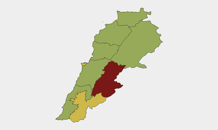
Beqaa Governorate (86.3) and Beirut (66.2) drive the composite risk ranking, with Nabatieh (63.6) emerging as the immediate flashpoint due to repeated Israeli strikes and ceasefire violations. The Beqaa's elevated score reflects its historical role as a weapons-transit and militant-logistics corridor; Beirut's risk reflects both political-negotiation fragility and infrastructure damage from prior bombardment. Nabatieh's spike is driven by active cross-border strike activity, civilian casualty incidents, and the presence of formal Israeli security operations in the south.
How GeoBit Would Assist
Security teams should deploy AOI Monitoring & Early Warning on Nabatieh, Beqaa, and the southern border zone to detect strike patterns and escalation signals ahead of 15–16 July negotiations. Satellite & Imagery analysis combined with GIS & Spatial Analysis can map damage corridors, verify ceasefire-line compliance, and identify safe corridors for personnel movement. Intel Sweep and multi-language OSINT on diplomatic channels and military-communication feeds will provide early warning of negotiation breakdown or renewed escalation.
7-Day Outlook
The 15–16 July Rome talks represent a critical decision point; Lebanese conditions on Israeli withdrawal create high collapse risk, potentially triggering renewed large-scale operations in the south. If negotiations stall, expect intensification of tit-for-tat strikes along the border and possible Hezbollah retaliation for the 10 July civilian casualties. Personnel and asset security in Beirut and southern Lebanon should remain elevated through mid-July, with particular attention to access routes and displacement patterns.
Highest-Risk Areas — Ranked
| # | State / Region | Risk |
|---|---|---|
| 1 | Beqaa Governorate | 86.3 |
| 2 | Beirut Governorate | 66.2 |
| 3 | Nabatieh Governorate | 63.6 |
| 4 | North Governorate | 56.3 |
| 5 | Akkar Governorate | 56.3 |
| 6 | Keserwan-Jbeil Governorate | 56.3 |
| 7 | Mount Lebanon Governorate | 56.3 |
| 8 | South Governorate | 56.3 |
| 9 | Baalbek-Hermel Governorate | 56.3 |
Sources
Previous Daily Briefs
A new Lebanon brief is written every day — each with its own risk map and downloadable CSV. Here's the last week; use the calendar to go further back.
📅 Browse every day by calendar →
Highlighted days have a brief. Tap a day for that day's map & analysis, or “csv” for that day's dataset ($5).
Atlas — our AI intelligence desk — emails them this snapshot personally. Nothing else, no list.