Situation Summary
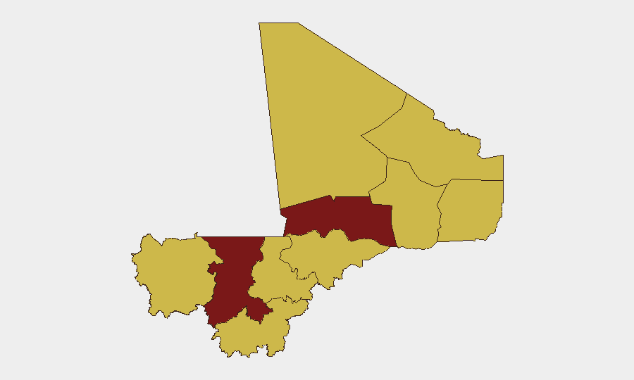
Mali remains a high-threat operating environment (composite threat rank #20 globally, score 89) with persistent armed-group activity, military engagement, and critical infrastructure stress. The most acute risks are concentrated in the northwest (Koulikoro, Timbuktu) and far north (Ménaka, Kidal, Gao), where jihadist networks and splinter factions sustain kinetic operations and abduction activity. Countrywide fuel shortages are compounding mobility and service delivery risks, while press-control measures suggest elevated state-security vigilance. The security trajectory remains volatile with no clear de-escalation signal.
Key Developments
- Kalana (Guinean border, Koulikoro region) — 26 June 2026 — Geolocated imagery confirmed a burned-out vehicle following a JNIM (Jama'at Nusrat al-Islam wa-l-Muslimin) attack, indicating fresh kinetic activity in the southwest border zone and underscoring Koulikoro's status as the country's highest-risk region.
- Sikasso region — 29 June 2026 — Mali's armed forces announced the dismantling of a major illegal fuel-smuggling network, suggesting both organized crime penetration and military counteraction in the south.
- Countrywide — ongoing as of 30 June 2026 — Fuel scarcity continues to constrain civilian and security-force movement and basic services; no significant relief announced in the last 48 hours.
- Northern regions (Timbuktu focus) — late June 2026 — Multi-day water and electricity outages reported due to fuel unavailability, degrading living conditions and potentially increasing civilian vulnerability.
- Bamako / countrywide — late June 2026 — Ongoing arrests and suspensions of journalists and radio programs reflect intensified press-control operations; no discrete new incident confirmed in the last 24 hours, but pattern remains active.
Highest-Risk Areas
Koulikoro (92.4) and Timbuktu (85.4) carry composite risk scores substantially above the national average, driven by sustained JNIM and other armed-group presence, ongoing military-insurgent contact, and infrastructure vulnerability. The far-northern tier (Ménaka, Kidal, Gao) and Kayes all score 62.4+, reflecting fragmented jihadist and criminal networks and border permeability. Bamako, despite its capital status and military deployment density, is assigned the same 62.4 score as these outlying regions, indicating organized-crime, political-detention, and transnational legal risks. Southwest and southern regions (Sikasso, Ségou, Mopti) also register at 62.4, reflecting smuggling networks and spillover activity from neighboring Burkina Faso.
How GeoBit Would Assist
AOI Monitoring & Early Warning with persistent geofencing around Koulikoro, Timbuktu, and Kalana would detect kinetic incidents and militant movements in near-real time. Conflict & Military mapping combined with Network & Actor Analysis enables tracking of JNIM splinter units, force-position changes, and abduction-risk corridors. Economic & Trade analysis would monitor fuel-supply disruption cascades and smuggling-network resurgence, informing movement and logistics planning for corporate assets and personnel.
7-Day Outlook
Jihadist and armed-group activity is likely to persist at current tempo in the northwest and north, with potential for further kidnapping or ambush incidents along key routes. Fuel shortages show no sign of immediate relief, continuing to degrade civilian services and constraining legitimate commerce. Military-government press controls may intensify ahead of any announced policy or political moves, increasing uncertainty for international and local stakeholders.
Highest-Risk Areas — Ranked
| # | State / Region | Risk |
|---|---|---|
| 1 | Koulikoro | 92.4 |
| 2 | Timbuktu | 85.4 |
| 3 | Ménaka | 62.4 |
| 4 | Kayes | 62.4 |
| 5 | Taoudénit Region | 62.4 |
| 6 | Kidal | 62.4 |
| 7 | Gao | 62.4 |
| 8 | Bamako | 62.4 |
| 9 | Ségou Region | 62.4 |
| 10 | Sikasso Region | 62.4 |
| 11 | Mopti | 62.4 |
Sources
Previous Daily Briefs
A new Mali brief is written every day — each with its own risk map and downloadable CSV. Here's the last week; use the calendar to go further back.
📅 Browse every day by calendar →
Highlighted days have a brief. Tap a day for that day's map & analysis, or “csv” for that day's dataset ($5).