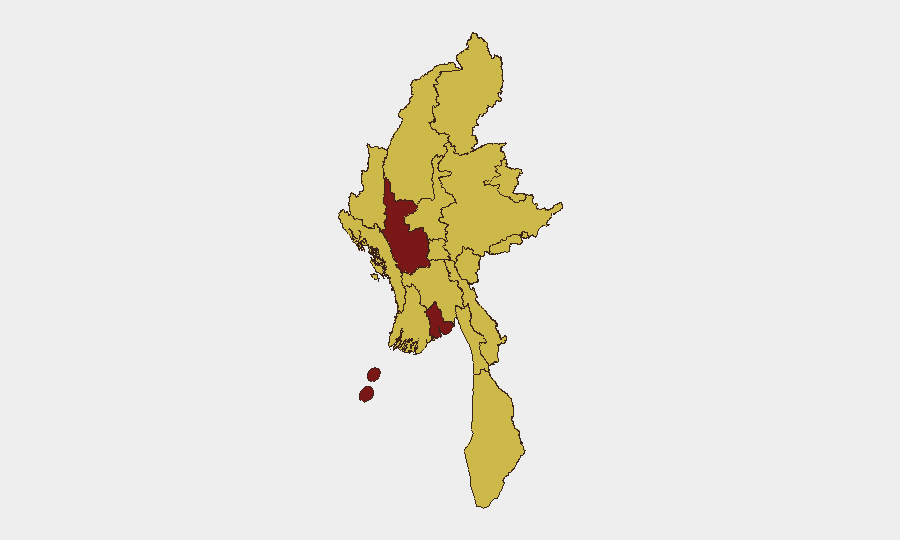
Situation Summary
Myanmar remains in active civil conflict following the February 2021 military coup, with resistance forces and government troops engaged across multiple regions. Conventional military operations are ongoing, and cross-border tensions with Thailand have escalated into public diplomatic statements as of 29 June 2026. The composite national threat score of 92 reflects sustained armed conflict, with secondary hazards including recent flooding affecting multiple areas. The trajectory remains unstable, with no clear de-escalation pathway evident.
Key Developments
- 29 June 2026 · Conventional Military Operations – Government forces engaged in active combat operations; specific location and unit details pending corroboration from field sources.
- 29 June 2026 · Thailand–Myanmar Border Tensions – Thai authorities issued public statements regarding Myanmar security situation on two separate occasions, suggesting elevated diplomatic concern and possible cross-border incident activity.
- Recent · Flooding Events (IDs 1103975, 1103937) – Multiple flood incidents recorded across Myanmar; exact dates and affected regions require clarification, but represent concurrent environmental hazard alongside conflict.
- 21–23 June 2026 · Reported Clashes – Unconfirmed social media reporting of armed clashes between government forces and resistance groups in central regions during this window; awaiting independent corroboration.
Note: Reliable cross-confirmed incident detail for the last 24–48 hours is currently limited. Ongoing monitoring required to establish specific casualty figures, displacement numbers, or tactical developments.
Highest-Risk Areas
Magway Region (94.6) emerges as the single highest-risk sub-national area, followed by Yangon (85.4), with all other tracked regions ranging from 64.6 to 65.4. The concentration of risk in Magway reflects sustained military activity and likely resistance-held or contested territory; Yangon's elevated score reflects urban conflict potential, critical infrastructure vulnerability, and population density. The relatively uniform mid-range scores across Shan, Chin, Sagaing, Kachin, Tanintharyi, and the Wa State reflect the distributed nature of armed opposition across Myanmar's periphery and central zones. Any organization with personnel or assets in Magway faces immediate exposure; Yangon concentrations warrant heightened duty-of-care protocols despite its lower absolute ranking.
How GeoBit Would Assist
Real-time AOI Monitoring & Early Warning on Magway, Yangon, and conflict-active border zones enables corporate security teams to receive automated alerts when violence, checkpoints, or military deployments occur near their facilities or personnel routes. Battle Mapping and Force Structure tracking provides geospatial intelligence on active frontlines, government and resistance positions, and expected movement corridors—critical for route planning and facility lockdown decisions. Intel Sweep and multi-language OSINT (X/Twitter, Telegram, local news) combined with Sentiment & Temporal Analysis give teams real-time assessment of on-the-ground conditions without reliance on official channels, reducing decision latency in emergencies.
7-Day Outlook
Military operations are expected to persist across Magway and periphery regions; no negotiated pause is signaled. Thai border activity may remain elevated if cross-border spillover or refugee flows continue. Flooding may compound displacement and restrict road access, particularly affecting supply chains and personnel movement in affected areas.
Highest-Risk Areas — Ranked
| # | State / Region | Risk |
|---|---|---|
| 1 | Magway | 94.6 |
| 2 | Yangon | 85.4 |
| 3 | Tanintharyi Region | 64.6 |
| 4 | Shan State | 64.6 |
| 5 | Chin | 64.6 |
| 6 | Sagaing Region | 64.6 |
| 7 | Kachin State | 64.6 |
| 8 | Wa State (Northern Region) | 64.6 |
| 9 | Mandalay | 64.6 |
| 10 | Rakhine | 64.6 |
| 11 | Ayeyarwady | 64.6 |
| 12 | Naypyitaw Union Territory | 64.6 |
Sources
Previous Daily Briefs
A new Myanmar brief is written every day — each with its own risk map and downloadable CSV. Here's the last week; use the calendar to go further back.
📅 Browse every day by calendar →
Highlighted days have a brief. Tap a day for that day's map & analysis, or “csv” for that day's dataset ($5).