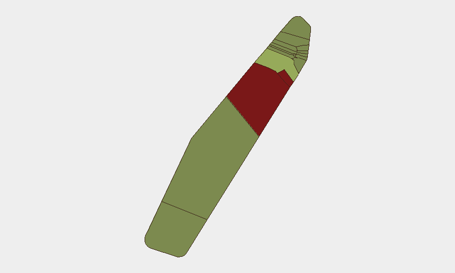
Situation Summary
Palau remains in a low-threat, stable operating environment with no verified security incidents, civil unrest, crime surges, or infrastructure disruptions reported in the past 24–48 hours. National and regional assessments confirm normal port and airport operations, no active curfews or emergency alerts, and no corroborated new security events. The threat landscape is dominated by longer-standing patterns—tourism-related theft and maritime incidents—rather than acute destabilization.
Key Developments
- Palau (country-wide) – 2026-08-21 to 2026-08-22: Regional security assessment confirms absence of civil unrest, crime spikes, security incidents, or infrastructure disruptions across the preceding 24–48 hours; normal operations at ports and airports with no emergency alerts in effect.
- Palau (country-wide) – 2026-08-21 (advisory publication): China's consular authorities issue new travel advisory to Palau, citing historical pattern of theft/robbery incidents targeting tourists and frequent accidents in aquatic environments; advisory reflects ongoing risk characterization rather than a specific incident in the past 48 hours.
- Western Pacific (near Palau) – Northern Mariana Islands / Rota region – 2026-08-22, 07:43 UTC: Magnitude 4.6 earthquake recorded in broader Palau–Mariana region; no reported damage or disruption to infrastructure or operations in Palau proper.
- Pacific EEZs (Kiribati, Palau, Papua New Guinea) – 2026-08-22: Regional fisheries enforcement operation detains multiple Chinese and Indonesian vessels for alleged illegal fishing or licensing violations; Palau authorities participate as one of several Pacific states, though exact port of detention and operational scope remain unclear in open sources.
- Palau-flagged maritime asset (off Somalia) – ongoing since 2026-04-21: Somali pirates continue to hold product tanker *Honour 25* (Palau-registered) and multinational crew hostage; ransom negotiations remain stalled as of 2026-08-23. *Note:* This is a maritime security issue involving Palau-registered shipping but located off Somali coast, not within Palau territory.
Highest-Risk Areas
Peleliu (risk 92) and Angaur (risk 88) significantly exceed national and regional baselines, likely reflecting historical conflict legacies, limited infrastructure, and reduced state capacity rather than acute current instability. Koror (risk 45), as the commercial and tourism hub, carries elevated risk tied to petty crime, accident exposure in water-based activities, and transient populations. Remaining states (Melekeok through Ngchesar) remain below 40 on the composite index and are not materially driving national security posture. Corporate and duty-of-care teams should weight Koror exposure prominently given tourism and business concentration; Peleliu and Angaur warrant caution for project or personnel deployment owing to limited rescue, medical, and law-enforcement capacity.
How GeoBit Would Assist
Teams with personnel or assets in Palau should deploy AOI Monitoring & Early Warning on Koror and secondary states to detect emerging crime clusters or accident surges affecting expatriate or tourism communities. Multi-language OSINT and entity extraction of Chinese, Indonesian, and regional consular advisories will provide early signal of travel warnings or enforcement actions that may affect supply chains or business continuity. Maritime & Aviation tracking will monitor Palau-flagged vessel movements and port activity, particularly given the ongoing *Honour 25* detention and regional fishing-enforcement tempo.
7-Day Outlook
No acute security escalation is anticipated in the next seven days. The operating environment is forecast to remain stable and low-incident. Corporate teams should maintain routine monitoring of tourism crime patterns, maritime enforcement operations, and consular advisories, while prioritizing contingency planning for medical evacuation and search-and-rescue scenarios in Koror's aquatic environment.
Highest-Risk Areas — Ranked
| # | State / Region | Risk |
|---|---|---|
| 1 | Peleliu | 92 |
| 2 | Angaur | 88 |
| 3 | Koror | 45 |
| 4 | Melekeok | 35 |
| 5 | Airai | 32 |
| 6 | Ngatpang | 28 |
| 7 | Ngeremlengui | 26 |
| 8 | Ngaraard | 25 |
| 9 | Ngardmau | 24 |
| 10 | Aimeliik | 23 |
| 11 | Ngiwal | 22 |
| 12 | Ngchesar | 21 |
Sources
Previous Daily Briefs
A new Palau brief is written every day — each with its own risk map and downloadable CSV. Here's the last week; use the calendar to go further back.
- August 22, 2026
- August 19, 2026
- August 16, 2026
- August 14, 2026
- August 12, 2026
- August 10, 2026
- August 8, 2026
📅 Browse every day by calendar →
Highlighted days have a brief. Tap a day for that day's map & analysis, or “csv” for that day's dataset ($5).
Atlas — our AI intelligence desk — emails them this snapshot personally. Nothing else, no list.