Situation Summary
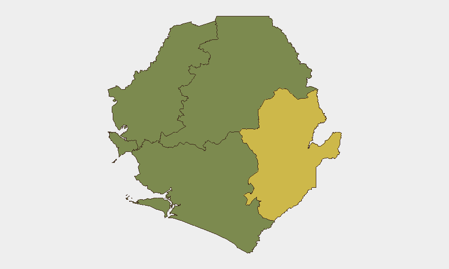
Sierra Leone remains a moderate composite threat (rank #60 globally, score 29) with acute tension concentrated in the Eastern Province, where border friction with Guinea and ongoing drug-trafficking activity create the primary risk surface. Current political developments—including the July 16 discontinuation of treason charges against former President Koroma ahead of the ECOWAS 69th Ordinary Session—signal an attempt by the national government to ease domestic political volatility. However, simultaneous firearm and narcotics seizures across the country, combined with unresolved border-security tensions near Yenga (Kailahun District), indicate fragmented but persistent baseline instability in security enforcement and border governance.
Key Developments
- Ferry Junction, Freetown (Western Area) – 16 July 2026: Police checkpoint arrest of kekeh operator Ibrahim Badamasi with concealed AK-47 rifle and 26 rounds of ammunition; suspect transferred to Ross Road Police Station and remains in custody.
- Mile 38 checkpoint, Freetown–Masiaka highway – 16 July 2026: Joint Sierra Leone Police and Armed Forces operation seized a bale of suspected cannabis; three suspects arrested and investigations ongoing.
- Koidu/New Sembehun, Kono District (Eastern Province) – mid-July 2026 (reported last 48 hours): Community anti-drug initiative resulted in arrest of Ibrahim Kamara with 104 wraps of suspected synthetic drug ("kush"); suspect and contraband in custody pending investigation.
- ECOWAS 69th Ordinary Session, Lungi – 21 July 2026: Regional leaders formally urged Guinea to withdraw troops from disputed border areas Yenga and Lofa; ECOWAS tasked with accelerating technical assessment of border friction points. Session also enabled participation by former President Koroma after July 16 removal of treason charges.
- Yenga border area, Kailahun District – ongoing, restated 21 July 2026: ECOWAS communiqué reiterated long-standing Sierra Leone–Guinea border tensions; partial border reopening reported but tensions persist, maintaining localized conflict and travel risk despite diplomatic efforts.
Highest-Risk Areas
Eastern Province (risk score 68) dominates the threat landscape, driven by active cross-border friction at Yenga/Lofa, ongoing drug-trafficking enforcement activity (Kono District arrests), and limited state capacity in remote divisional areas. Western Area (score 35) reflects firearm trafficking and urban-security incidents near Freetown's transit hubs, though current political steps to ease tensions may reduce near-term instability. Northern, North West, and Southern Provinces register minimal indexed risk (score 0) and do not currently warrant elevated monitoring focus for most corporate operations.
How GeoBit Would Assist
Security and duty-of-care teams should employ AOI Monitoring & Early Warning on the Yenga border zone and Kailahun District to detect escalation in cross-border military activity or civilian displacement. Conflict & Military capabilities (force-structure and weapons-tracking) and Network & Actor Analysis would clarify state and non-state armed-group positioning ahead of any border incident. Routing & Network Analysis enables alternative journey planning for staff in Eastern Province or transiting the Freetown–Masiaka corridor to avoid checkpoint and trafficking-related detention risks.
7-Day Outlook
The ECOWAS summit and removal of treason charges suggest near-term political stabilization, but border tensions remain unresolved and dependent on Guinea's troop-withdrawal commitment. Baseline drug-trafficking and firearm seizures are likely to continue in Western Area and Eastern Province checkpoints; no sharp escalation is signaled, but localized friction and travel delays should be anticipated in border and transit-choke-point areas through end-July.
Highest-Risk Areas — Ranked
| # | State / Region | Risk |
|---|---|---|
| 1 | Eastern Province | 68 |
| 2 | Western Area | 35 |
| 3 | North West Province, Sierra Leone | 0 |
| 4 | Northern Province, Sierra Leone | 0 |
| 5 | Southern Province, Sierra Leone | 0 |
Sources
Previous Daily Briefs
A new Sierra Leone brief is written every day — each with its own risk map and downloadable CSV. Here's the last week; use the calendar to go further back.
📅 Browse every day by calendar →
Highlighted days have a brief. Tap a day for that day's map & analysis, or “csv” for that day's dataset ($5).
Atlas — our AI intelligence desk — emails them this snapshot personally. Nothing else, no list.