Situation Summary
South Sudan remains in a state of fragile conflict equilibrium, with no discrete verified security incidents recorded in the last 24–48 hours by open-source trackers and field sources. The country's #19 global threat ranking (composite score 68) reflects the ongoing civil war and deep institutional instability, though the current observation window shows a lull in tracked event frequency rather than a reduction in underlying risk. Central Equatoria and Upper Nile remain the primary drivers of elevated threat, and the absence of new incidents does not signal improved security conditions—rather, it reflects the intermittent, dispersed nature of violence across a fractured territory.
Key Developments
No reliably confirmed, South Sudan–specific security incidents have been verified in the last 24–48 hours by quantitative risk trackers or multi-source open-source intelligence. Ongoing monitoring by OSINT feeds, YouTube/podcast intelligence, and web research has not yielded discrete dated incidents meeting strict recency criteria.
Note on near-recent incidents (outside strict 24–48h window but operationally relevant):
- Juba, National Security Service ("Blue House") headquarters – early July: A fire was reported at the NSS headquarters; the exact date and casualty status remain unclear from available sources, and the incident cannot be confirmed as occurring within the last 48 hours.
- Juba–Bor Highway, near Mongalla – mid-to-late July: An intercity bus was attacked by gunmen; the driver sustained gunshot wounds and three passengers were injured by broken glass. Perpetrators remain unidentified and investigations are ongoing.
- Jonglei and Upper Nile states – 7 July 2026 (background context): Renewed fighting resulted in at least one county commissioner killed and a 50%+ increase in wounded evacuees reported by the ICRC, indicating elevated casualty throughput in that period.
Border engagement (cooperative, non-incident): South Sudan and Uganda agreed to reactivate joint border security committees and to re-mark their 470-km shared border by 2027, following a meeting in Arua District—a positive indicator of bilateral stabilization efforts rather than a security incident.
Highest-Risk Areas
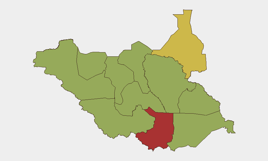
Central Equatoria (risk score 77.2) and Upper Nile (62.2) dominate the sub-national threat ranking and account for the majority of tracked conflict activity. Central Equatoria's elevated risk reflects proximity to Juba, competition for control of key infrastructure and supply routes, and lingering factional tensions within government and armed forces. Upper Nile's risk profile is driven by recurring clashes between Nuer and other ethnic militias, as well as incursions by forces aligned with splinter factions. The remaining ten states and administrative areas cluster at a secondary risk tier (47.2), indicating that while violence is more frequent in the top two regions, conflict risk is geographically distributed and can erupt rapidly in peripheral zones (e.g., Jonglei, Ruweng, Lakes, Eastern Equatoria).
How GeoBit Would Assist
Intel Sweep, OSINT fusion, and multi-language search would enable continuous monitoring of fragmented armed groups and factional statements across Telegram, X, and community radio channels—critical in an environment where organized media reporting is limited. AOI (Area-of-Interest) monitoring and early warning on Central Equatoria, Upper Nile, and key transport corridors (Juba–Bor Highway, supply routes to Bentiu) would provide persistent watch and real-time alerting when activity spikes or movement is detected. Conflict and military force-structure tracking, combined with network and actor analysis, would map shifting command relationships and faction alignments to flag emerging flashpoints before violence escalates.
7-Day Outlook
No significant escalation is forecast in the immediate 7-day window; the current lull is consistent with seasonal and logistical patterns rather than a durable ceasefire. Heightened vigilance remains warranted in Central Equatoria and Upper Nile, where localized clashes or checkpoint friction could occur with minimal warning. Organizations with personnel or assets in the country should maintain communication redundancy and position-aware contingency protocols.
Highest-Risk Areas — Ranked
| # | State / Region | Risk |
|---|---|---|
| 1 | Central Equatoria | 77.2 |
| 2 | Upper Nile | 62.2 |
| 3 | Northern Bahr el Ghazal | 47.2 |
| 4 | Western Bahr el Ghazal State | 47.2 |
| 5 | Ruweng Administrative Area | 47.2 |
| 6 | Unity | 47.2 |
| 7 | Warrap | 47.2 |
| 8 | Lakes | 47.2 |
| 9 | Jonglei | 47.2 |
| 10 | Greater Pibor Administrative Area | 47.2 |
| 11 | Western Equatoria | 47.2 |
| 12 | Eastern Equatoria | 47.2 |
Sources
Previous Daily Briefs
A new South Sudan brief is written every day — each with its own risk map and downloadable CSV. Here's the last week; use the calendar to go further back.
📅 Browse every day by calendar →
Highlighted days have a brief. Tap a day for that day's map & analysis, or “csv” for that day's dataset ($5).
Atlas — our AI intelligence desk — emails them this snapshot personally. Nothing else, no list.