Situation Summary
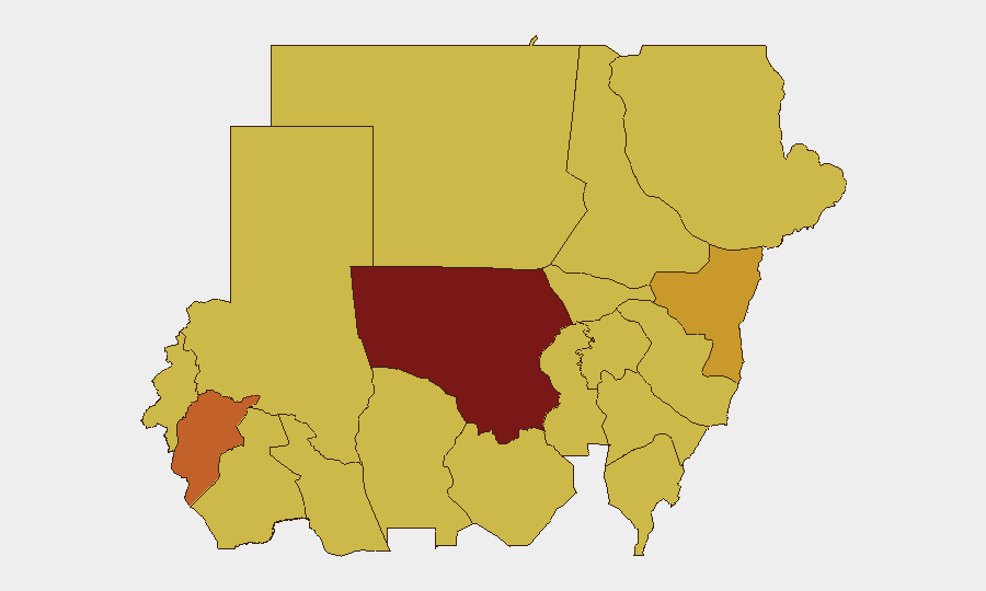
Sudan remains in active civil war with composite threat rank #6 globally; the past 48 hours have seen renewed conventional military escalation in North Kordofan and confirmed RSF drone activity amid reports of the Sudanese army consolidating control in Khartoum. El Obeid, the state capital of North Kordofan (risk score 100), is under encirclement with verified attacks on critical infrastructure, civilian casualties, and humanitarian access restrictions—mirroring tactics seen in the El Fasher siege. The trajectory is one of geographic concentration: conflict intensity is rising in the northwest while security gains are reported in the capital, creating a bifurcated risk profile.
Key Developments
- El Obeid, North Kordofan (8–9 July 2026): UN reporting confirms the city is under encirclement with attacks on critical infrastructure (power, water) and five oil tank farms reported hit by RSF drone strikes; siege conditions are ongoing and worsening.
- El Obeid, North Kordofan (June 2026, reported 8–9 July 2026): UN verified 15 drone strikes over three weeks in June resulting in at least 45 civilian deaths, demonstrating sustained high-tempo RSF air operations in the region.
- El Obeid, North Kordofan (8–9 July 2026): Renewed fighting between Sudanese army and RSF is intensifying around the city; UN warns RSF is applying El Fasher-style tactics including attacks on civilian assets and deliberate humanitarian access restriction.
- Khartoum (8 July 2026): Sudanese army announced clearance of the last RSF pockets in the capital following regain of the airport, security headquarters, and several key military sites.
- Sudan-wide (7–9 July 2026): Multiple international bodies (UN, Arab League, Amnesty International, rights groups) issued threats and disapprovals in response to military conduct; arrests/detention of judges and ongoing investigations signal internal governance instability.
Highest-Risk Areas
North Kordofan State dominates the threat landscape (risk 100), driven by active siege warfare, drone strikes, and infrastructure attacks in El Obeid. Central Darfur, Kassala, North Darfur, and Blue Nile follow at 70–74 risk scores, reflecting ongoing conventional military activity and humanitarian crises across the periphery. The clustering of risk in the northwest and east—all above 70—indicates the conflict remains geographically dispersed despite reported army consolidation in Khartoum, with Darfur and Kordofan representing the most active war zones for corporate operations.
How GeoBit Would Assist
Teams with assets or personnel in Sudan should employ AOI Monitoring & Early Warning on North Kordofan (especially El Obeid) and verified Darfur hotspots to receive real-time alerts on attack patterns, siege tightening, and humanitarian access changes. Battle Mapping, Force Structure, and Weapons-Capability Tracking provide tactical clarity on army vs. RSF dispositions and drone threat evolution, critical for route planning. Routing & Network Analysis and Satellite & Imagery Analysis enable identification of alternative supply corridors and assessment of infrastructure damage in real time, directly supporting duty-of-care decisions on staff movement and supply chains.
7-Day Outlook
Intensification around El Obeid is probable given reported RSF momentum and army counteroffensive; siege conditions are likely to tighten further, restricting humanitarian access and civilian movement. Khartoum may remain relatively stabilized following army gains, but fragile security there does not extend to the periphery. Corporate risk teams should assume North Kordofan and Darfur will remain high-friction zones for at least the next week.
Highest-Risk Areas — Ranked
| # | State / Region | Risk |
|---|---|---|
| 1 | North Kordofan State | 100 |
| 2 | Central Darfur State | 73.7 |
| 3 | Kassala State | 71.2 |
| 4 | North Darfur State | 70.2 |
| 5 | Blue Nile | 70 |
| 6 | River Nile State | 70 |
| 7 | Al Khartum | 70 |
| 8 | Aj Jazira | 70 |
| 9 | Red Sea State | 70 |
| 10 | Al Qadarif State | 70 |
| 11 | Sennar State | 70 |
| 12 | South Darfur State | 70 |
Sources
Previous Daily Briefs
A new Sudan brief is written every day — each with its own risk map and downloadable CSV. Here's the last week; use the calendar to go further back.
📅 Browse every day by calendar →
Highlighted days have a brief. Tap a day for that day's map & analysis, or “csv” for that day's dataset ($5).
Atlas — our AI intelligence desk — emails them this snapshot personally. Nothing else, no list.