Situation Summary
Suriname remains a low-threat environment globally (rank #173), but sub-national risk is heavily concentrated in the interior and eastern border regions, with Sipaliwini district presenting critical vulnerability. No significant security incidents have been reliably documented in the past 24–48 hours; the security posture remains stable. Armed robbery and road traffic fatalities constitute the primary civilian risks in populated areas, while interior regions face broader criminal and smuggling activity.
Key Developments
No security or unrest incidents in Suriname have been reliably confirmed for 15–16 August 2026. Recent verified events include:
- 13 August, Santopolderweg (Paramaribo region) – Fatal traffic incident; female pedestrian struck during overtaking maneuver; police investigation initiated.
- 11 August, Weg naar Paranam (Wanica district) – Residents erected barricades in protest; incident occurred outside current 24–48-hour window but indicates localized grievance activity.
- 11 August, Paramaribo – Armed home invasion; three masked gunmen forced entry, threatened female resident at gunpoint, and fled with jewelry and cash.
No imminent escalation signals detected. Current event volume remains low and non-systemic.
Highest-Risk Areas
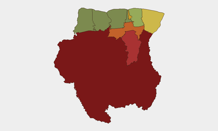
Sipaliwini district (risk 92) dominates the threat landscape, reflecting its remote interior location, limited state presence, and exposure to transnational smuggling networks and illegal mining. Brokopondo (78) and Para (74) follow, both economically and geographically vulnerable to organized crime activity. Paramaribo (71), despite being the capital, ranks fourth due to armed street crime, home invasions, and vehicle theft targeting residents and expatriates. Collectively, these four districts account for the country's actionable security burden; the coastal corridor west of Paramaribo (Commewijne, Wanica, Saramacca) and the far northwest (Nickerie) pose substantially lower risk.
How GeoBit Would Assist
Teams with personnel or assets in Suriname should employ AOI Monitoring & Early Warning on high-risk districts (Sipaliwini, Paramaribo, Brokopondo) to detect criminal activity, smuggling, or protest escalation in near-real time. Intel Sweep and OSINT fusion across local news, X/Twitter, and regional feeds will provide corroborated incident confirmation and timeline verification—critical given current sparse English-language coverage. GIS & Spatial Analysis combined with Routing & Network Analysis enables security teams to map safe corridors, identify high-incident zones by block or border crossing, and plan duty-of-care evacuations or supply routes around identified hotspots.
7-Day Outlook
No acute deterioration is expected over the next 7 days. Risk will remain regionally differentiated—interior and eastern border zones will continue experiencing criminal activity and smuggling pressure, while populated coastal centers (Paramaribo, Lelydorp) will see routine street crime and traffic incidents. Monitor for any escalation in protest activity or armed robbery frequency in Paramaribo; uptick in either would signal shifting criminal tactics or social grievance.
Highest-Risk Areas — Ranked
| # | State / Region | Risk |
|---|---|---|
| 1 | Sipaliwini | 92 |
| 2 | Brokopondo | 78 |
| 3 | Para | 74 |
| 4 | Paramaribo | 71 |
| 5 | Marowijne | 68 |
| 6 | Commewijne | 42 |
| 7 | Wanica | 38 |
| 8 | Saramacca | 29 |
| 9 | Coronie | 12 |
| 10 | Nickerie | 8 |
Sources
Previous Daily Briefs
A new Suriname brief is written every day — each with its own risk map and downloadable CSV. Here's the last week; use the calendar to go further back.
- August 14, 2026
- August 12, 2026
- August 10, 2026
- August 8, 2026
- August 6, 2026
- August 5, 2026
- August 4, 2026
📅 Browse every day by calendar →
Highlighted days have a brief. Tap a day for that day's map & analysis, or “csv” for that day's dataset ($5).
Atlas — our AI intelligence desk — emails them this snapshot personally. Nothing else, no list.