Situation Summary
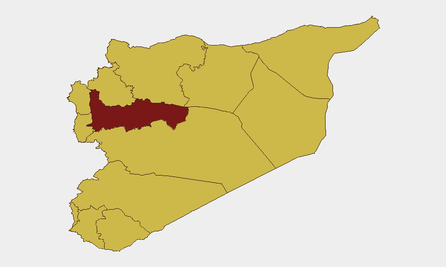
Syria remains in a critical post-transition phase following the fall of the Assad regime, with the new government attempting to consolidate control while managing residual terrorism, cross-border threats, and regional fragmentation. A significant terrorist attack in central Damascus on 2 July, combined with ongoing Israeli incursions, ISIL/Daesh activity across multiple governorates, and civil unrest in southern regions, indicates that institutional stabilization has not yet arrested underlying security fractures. Damascus Governorate carries the highest sub-national risk (96), driven by terrorism and counter-terrorism operations, while southern governorates remain destabilized by protest and territorial disputes. The trajectory is volatile: near-term risk depends on whether the new transitional parliament can build legitimacy and whether security operations contain extremist networks before further mass-casualty incidents occur.
Key Developments
- Damascus (central, Palace of Justice vicinity) – 2 July 2026
A bomb blast at a café killed 5–9 people and wounded ~20; no immediate claim of responsibility; Syrian authorities launched a manhunt for perpetrators. *Terrorism, urban casualty risk, central-city movement restrictions.*
- Damascus (security operations) – 2–3 July 2026
Internal security and intelligence units conducted intensive raids across multiple Damascus districts, detaining suspects and tightening central checkpoints in response to the café bombing. *Counter-terrorism operations, checkpoint delays, potential detention of civilians.*
- Damascus (government messaging) – 2–3 July 2026
Intelligence chief Hussein al-Salama stated the government has shifted from "managing crises" to "building sustainable stability," framing recent operations as long-term stabilization efforts. *Political narrative; risk perception may not match operational reality on ground.*
- Syria–Israel border and military zones – 2 July 2026
Syrian state media condemned fresh Israeli strikes and incursions; posts referenced border areas and military infrastructure, though casualty/damage figures were not detailed. *Cross-border military risk, infrastructure vulnerability near military sites.*
- National level – 1–2 July 2026
President Ahmed al-Sharaa appointed 70 lawmakers to transitional parliament, scheduled to convene within days; appointment risks triggering political contestation and protests, especially in transitional-justice-sensitive areas. *Political instability, protest risk, institutional transition uncertainty.*
- Suweida and southern Syria – late June–early July 2026
Ongoing civil unrest and protests reported in Suweida and adjacent areas over territorial control and grievances against Damascus; assessed as threat to national unity and local stability. *Civil unrest, intercommunal tension, south-to-north instability spillover.*
- Aleppo, Raqqa, rural Damascus – June–early July 2026
ISIL/Daesh claimed multiple attacks targeting security personnel; Interior Ministry reported three-month counter-terrorism campaign dismantling cells and seizing weapons/explosives across multiple governorates. *Highway and rural insecurity, ongoing counter-terrorism disruptions to logistics and travel.*
Highest-Risk Areas
Damascus Governorate's risk score of 96 reflects the concentration of state institutions, symbols, and terrorist targeting in the capital; the 2 July café bombing underscores that central Damascus remains a viable attack surface despite security operations. Hama, As-Suweida, and the coastal governorates (Lattakia, Tartus) form a second tier of concern: Hama due to residual militant presence and ISIL activity; As-Suweida due to civil unrest and southern fragmentation; and the coast due to proximity to military infrastructure and Israeli operations. Outlying rural and border zones (Idleb, Raqqa, northern Aleppo) remain hotbeds of ISIL/Daesh operational activity, making highways and logistics routes in those areas significantly more dangerous.
How GeoBit Would Assist
Corporate security teams operating in or near Damascus should activate AOI Monitoring & Early Warning on central districts and key facilities to detect protest mobilization and checkpoint expansion before they disrupt operations. Conflict & Military tracking combined with Border & Disputed-Territory search provides near-real-time intelligence on Israeli incursions and Syrian military responses, enabling risk teams to anticipate airspace closures and infrastructure impacts. Routing & Network Analysis is critical for supply chains and personnel movement: alternative route planning that avoids ISIL-active zones in Raqqa, Aleppo, and rural Damascus, plus real-time checkpoint intelligence, can mitigate both terrorism and counter-terrorism operation delays.
7-Day Outlook
The appointment and convening of the transitional parliament will likely generate political friction and localized protests, particularly in southern and minority-majority areas, increasing civil unrest risk in Damascus and secondary cities. Counter-terrorism operations are expected to intensify in response to the café bombing, with heightened checkpoints and security sweeps in Damascus and surrounding areas disrupting business as usual for at least 7–10 days. ISIL/Daesh will probably attempt follow-on attacks to exploit the security gap created by the parliament transition and reassert operational relevance; highways in Aleppo and Raqqa governorates should be considered high-risk for the near term.
Highest-Risk Areas — Ranked
| # | State / Region | Risk |
|---|---|---|
| 1 | Damascus Governorate | 96 |
| 2 | Hama Governorate | 80.9 |
| 3 | As-Suweida Governorate | 66.2 |
| 4 | Lattakia Governorate | 66 |
| 5 | Tartus Governorate | 66 |
| 6 | UNDOF | 66 |
| 7 | Al-Quneitra Governorate | 66 |
| 8 | Dar'a Governorate | 66 |
| 9 | Idleb Governorate | 66 |
| 10 | Aleppo Governorate | 66 |
| 11 | Ar-Raqqa Governorate | 66 |
| 12 | Homs Governorate | 66 |
Sources
Previous Daily Briefs
A new Syria brief is written every day — each with its own risk map and downloadable CSV. Here's the last week; use the calendar to go further back.
📅 Browse every day by calendar →
Highlighted days have a brief. Tap a day for that day's map & analysis, or “csv” for that day's dataset ($5).