Situation Summary
Angola remains at moderate composite threat level (#56 globally, score 33) with no verified major security incidents in the last 24–48 hours. The current picture reflects structural, not acute, risk: armed crime in Luanda, resource-competition tensions in the eastern provinces, and wildfire activity across multiple regions dominate the hazard landscape. The security environment is stable at the national level, though persistent sub-national vulnerabilities in frontier and resource-rich areas require sustained monitoring.
Key Developments
- Wildfire activity (nationwide, ongoing through 22 July): Multiple active wildfires documented across Angola including Cabinda, Lunda Norte, Lunda Sul, and other provinces; fire events are environmental hazards affecting transport corridors and population centers but are not themselves security events.
- No verified conflict, civil unrest, or infrastructure incidents (last 48 hours): Open-source monitoring across news, social media, and wire services confirms no time-stamped major security events (riots, insurgent activity, significant protests, service disruptions) in the 20–22 July window.
- Luanda armed-crime baseline (structural, not new spike): Elevated armed robbery and theft continue in and around commercial zones, restaurants, and hotels; this reflects persistent threat rather than a discrete recent incident.
- Eastern frontier provinces remain stable but vigilant (Cabinda, Lunda Norte/Sul): No new verified clashes or attacks reported in the last 48 hours, though inter-community and resource-related tensions remain a latent structural concern.
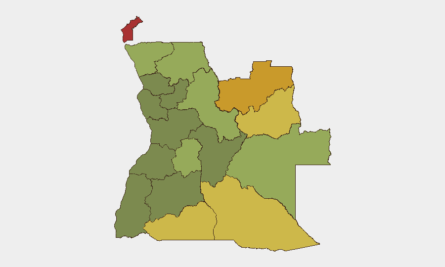
Highest-Risk Areas
Cabinda Province (risk 78) and the Lunda provinces (Norte 72, Sul 68) drive Angola's sub-national threat profile. These eastern and northeastern regions face converging pressures: competition over diamond and other mineral resources, porous borders with the Democratic Republic of Congo enabling cross-border criminal and militia activity, and weak state presence in remote areas. Cuando Cubango, Cunene, and Moxico provinces (scores 64–58) present secondary but significant risk from similar border vulnerabilities and inter-community friction. Luanda, while lower-ranked sub-nationally, concentrates urban crime and remains the principal exposure for corporate personnel and supply chains.
How GeoBit Would Assist
Security teams operating in Angola should deploy AOI Monitoring & Early Warning on Cabinda, Lunda Norte, and Luanda to catch emerging tensions or incidents before they mature into operational disruptions. OSINT fusion (news, social media, local radio SIGINT, and X/Twitter sentiment analysis) provides real-time visibility on developing civil unrest or criminal activity in Luanda and frontier areas. GIS & Spatial Analysis combined with Satellite & Imagery analysis enables tracking of wildfire spread, road blockages, and population displacement that can disrupt logistics and personnel movement; Routing & Network Analysis allows identification of alternative transport corridors when primary roads are threatened.
7-Day Outlook
No imminent escalation is indicated. Wildfire activity is expected to persist through the dry season, creating intermittent logistical friction but not direct security threat. Eastern frontier provinces will continue baseline monitoring for resource-driven tension; any cross-border militia activity or inter-community clash would likely be detected first via local reporting and cross-border intelligence sharing. Luanda armed-crime risk remains stable at elevated endemic levels. Corporate duty-of-care posture should remain alert but not elevated beyond current risk awareness.
Highest-Risk Areas — Ranked
| # | State / Region | Risk |
|---|---|---|
| 1 | Cabinda Province | 78 |
| 2 | Lunda Norte Province | 72 |
| 3 | Lunda Sul Province | 68 |
| 4 | Cuando Cubango Province | 64 |
| 5 | Cunene Province | 62 |
| 6 | Moxico Province | 58 |
| 7 | Zaire Province | 54 |
| 8 | Huambo Province | 50 |
| 9 | Uíge Province | 48 |
| 10 | Malanje Province | 42 |
| 11 | Bié Province | 35 |
| 12 | Huíla Province | 32 |
Previous Daily Briefs
A new Angola brief is written every day — each with its own risk map and downloadable CSV. Here's the last week; use the calendar to go further back.
📅 Browse every day by calendar →
Highlighted days have a brief. Tap a day for that day's map & analysis, or “csv” for that day's dataset ($5).
Atlas — our AI intelligence desk — emails them this snapshot personally. Nothing else, no list.