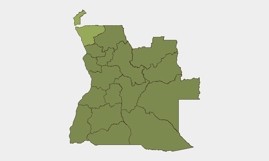
Situation Summary
Angola remains classified as moderate-risk globally (#54, composite score 34) with no verified security, civil-unrest, attack, or infrastructure incidents reported in the past 24–48 hours. The threat picture is shaped by persistent subnational instability in northern border provinces and localized armed-crime risk in urban centers, particularly Luanda, rather than acute nationwide crises. Wildfire activity across multiple provinces is ongoing but does not currently constitute a security incident trigger. The overall trajectory is stable with no indicators of imminent escalation.
Key Developments
- Angola (nationwide) — 20 Jul 2026 — Open-source monitoring confirmed no verified new security, conflict, civil-unrest, attack, or infrastructure-failure incidents in the 24–48-hour reporting window.
- Luanda Province — 20 Jul 2026 — Armed-crime risk remains persistent; however, no discrete new incident was reported during the assessment period.
- Cabinda & Zaire Provinces — 20 Jul 2026 — Both provinces continue to carry elevated structural instability risk; no fresh incident was verified in the last 48 hours.
- Lunda Norte, Lunda Sul, Moxico — 20 Jul 2026 — Border and diamond-region zones remain flagged as higher-risk areas; no new incident confirmed in the reporting window.
- Multiple Provinces — Recent period — Active wildfire events continue across Angola and cross-border zones (10+ tracked events); current status does not constitute acute security impact but warrants environmental/operational monitoring.
- Refugee vs. Angola Signals — 18 Jul 2026 — Conventional military-force event signals logged; details and scale remain under verification and do not yet appear in mainstream reporting.
Highest-Risk Areas
Cabinda and Zaire provinces drive the risk ranking, each with composite scores of 53.7—substantially higher than the nationwide average. Both are characterized by ongoing localized tension and subnational instability. A second tier of moderate-risk provinces (Lunda Norte, Lunda Sul, Bengo, and Moxico) score 23.7 and reflect border-zone volatility, diamond-region competition, and armed-crime persistence. Luanda Province, though ranked as moderate-risk, remains the primary urban crime and armed-robbery concern for corporate personnel and supply-chain assets. Cabinda's historical separatist tensions and Zaire's porous DRC border remain the primary drivers of elevated provincial risk.
How GeoBit Would Assist
Corporate teams with personnel or assets in Angola should employ AOI Monitoring & Early Warning on Cabinda, Zaire, and Luanda to detect discrete incident emergence in near-real time with alerting. OSINT Fusion & Corroboration across social media, local news, and radio SIGINT will enable early detection of unverified claims before they escalate. GIS & Spatial Analysis and Satellite & Imagery analysis can track wildfire spread, infrastructure exposure, and cross-border movement patterns in high-risk northern provinces, informing duty-of-care decisions on personnel movement and asset relocation.
7-Day Outlook
No acute escalation is forecast over the next seven days. The absence of verified new incidents in the 48-hour window, combined with stable political and security messaging, suggests the near-term trajectory will remain consistent with baseline subnational risk. Monitoring should remain focused on Cabinda and Zaire for any emergence of armed activity or refugee/displacement events, and on Luanda for urban crime and supply-chain disruption.
Highest-Risk Areas — Ranked
| # | State / Region | Risk |
|---|---|---|
| 1 | Cabinda Province | 53.7 |
| 2 | Zaire Province | 53.7 |
| 3 | Lunda Norte Province | 23.7 |
| 4 | Lunda Sul Province | 23.7 |
| 5 | Bengo Province | 23.7 |
| 6 | Luanda Province | 23.7 |
| 7 | Uíge Province | 23.7 |
| 8 | Cuanza Norte Province | 23.7 |
| 9 | Cuanza Sul Province | 23.7 |
| 10 | Malanje Province | 23.7 |
| 11 | Bié Province | 23.7 |
| 12 | Moxico Province | 23.7 |
Previous Daily Briefs
A new Angola brief is written every day — each with its own risk map and downloadable CSV. Here's the last week; use the calendar to go further back.
📅 Browse every day by calendar →
Highlighted days have a brief. Tap a day for that day's map & analysis, or “csv” for that day's dataset ($5).
Atlas — our AI intelligence desk — emails them this snapshot personally. Nothing else, no list.