Situation Summary
Benin remains in a heightened security state following the December 2025 coup attempt, with ongoing terrorist and kidnap threats concentrated in the northern border regions. The national threat composite score of 30 reflects a fragmented, geographically uneven risk profile: northern departments contend with active militant pressure and cross-border incursions, while southern and coastal zones maintain substantially lower incident rates. No major security event has been documented in the last 24–48 hours; the threat environment is characterized by persistent underlying tension rather than acute escalation.
Key Developments
No discretely confirmed security, conflict, civil unrest, or crime incidents meeting cross-source corroboration standards have been reported in Benin within the last 24–48 hours (04–06 August 2026). Web monitoring, regional security outlets, and diplomatic advisories show no newly dated attack, unrest, or infrastructure disruption within this window. Security posture remains operationally heightened in northern departments, with routine military and police controls reported, but no specific incident triggering alert in the immediate reporting period.
Highest-Risk Areas
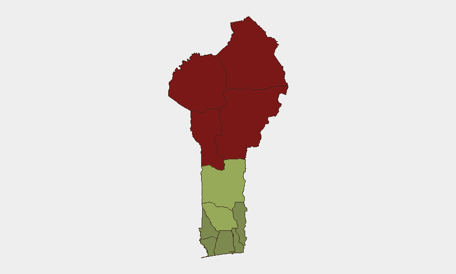
Four northern departments—Alibori (risk 92), Atakora (risk 88), Donga (risk 85), and Borgou (risk 83)—drive national risk, collectively accounting for the majority of documented terrorist activity, kidnapping, and cross-border militant transit. These zones share porous land borders with Burkina Faso, Niger, and Nigeria, all active theaters for Sahel-based militant groups. By contrast, southern departments (Ouémé, Littoral, Atlantique) score 22–28, reflecting substantially lower incident density and improved state capacity. Risk concentration in the north reflects both geography and governance: remote terrain, limited security force density, and militant group infiltration create persistent operational space for armed actors.
How GeoBit Would Assist
Security teams with personnel or assets in Benin should employ AOI Monitoring & Early Warning on the four high-risk northern departments to detect emerging attack patterns, militant movement, and checkpoint activity in near-real time. Intel Sweep and X/Twitter & Telegram OSINT capabilities enable continuous monitoring of militant communications, claims of responsibility, and local security reporting in French and local languages—critical for early tactical warning before formal diplomatic or media channels report incidents. Conflict & Military force-structure and Network & Actor Analysis track regional militant group organization, supply routes, and leadership, informing route planning and asset-movement risk assessment across the Sahel corridor.
7-Day Outlook
Northern Benin will likely maintain its current operational security posture: heightened checkpoint density, routine patrols, and low-profile militant activity without major publicized attacks. Political and security environment will remain sensitive in light of the April 2026 electoral cycle and December coup aftermath, but no specific triggering event is forecasted for the next week. Seasonal factors (dry-season transit patterns for cross-border groups) and neighboring Burkina Faso and Niger instability remain the principal drivers of medium-term risk escalation potential.
Highest-Risk Areas — Ranked
| # | State / Region | Risk |
|---|---|---|
| 1 | Alibori Department | 92 |
| 2 | Atakora Department | 88 |
| 3 | Donga Department | 85 |
| 4 | Borgou Department | 83 |
| 5 | Zou Department | 45 |
| 6 | Collines Department | 42 |
| 7 | Plateau Department | 38 |
| 8 | Kouffo Department | 35 |
| 9 | Mono Department | 32 |
| 10 | Atlantique Department | 28 |
| 11 | Littoral | 25 |
| 12 | Ouémé Department | 22 |
Sources
Previous Daily Briefs
A new Benin brief is written every day — each with its own risk map and downloadable CSV. Here's the last week; use the calendar to go further back.
📅 Browse every day by calendar →
Highlighted days have a brief. Tap a day for that day's map & analysis, or “csv” for that day's dataset ($5).
Atlas — our AI intelligence desk — emails them this snapshot personally. Nothing else, no list.