Situation Summary
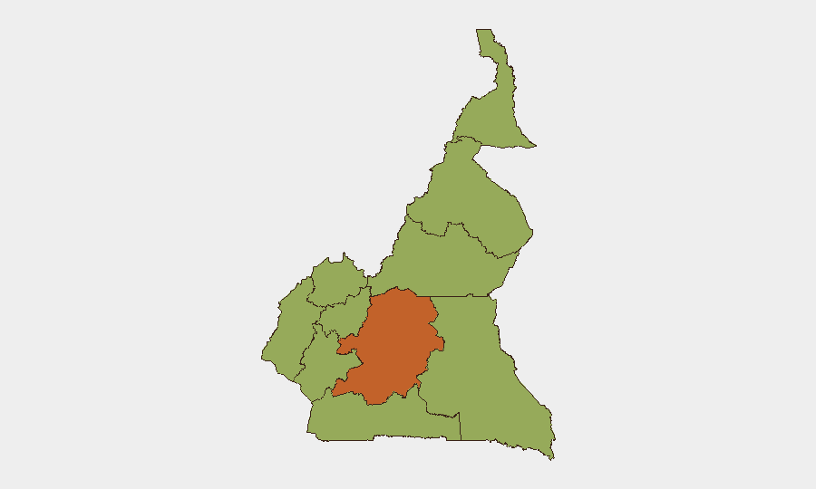
Cameroon remains a composite-threat environment (rank #31 globally, score 66) characterized by persistent Boko Haram insurgency in the Far North and ongoing Anglophone separatist violence in the Northwest and Southwest regions. The Centre region registers the highest sub-national risk (75.8), likely reflecting political instability and civil-order concerns around the capital Yaoundé. No clearly documented security incidents have been reliably timestamped to 21–22 July 2026 in open-source feeds; the most recent confirmed activity clusters between 14–20 July and centers on armed-group attacks against security infrastructure and civilian populations in the Far North and Southwest.
Key Developments
- Far North region (Tourou, Mokolo subdivision) – Night of 14–15 July 2026: Boko Haram fighters attacked a Cameroonian army advanced post, killing one civilian and wounding a 15-month-old child by gunfire; at least four soldiers were injured before the post repelled the assault.
- Far North region (Bargaram) – Night of 16–17 July 2026: Boko Haram fighters attacked a Rapid Intervention Battalion (BIR) post; follow-on Cameroonian operations resulted in five militant deaths, one soldier killed, and weapon seizures, indicating sustained insurgent pressure on military installations.
- Southwest region (Mile 16, Bolifamba, Buea) – 16 July 2026: Ambazonia separatist fighters overran a Cameroonian security checkpoint on the Mutengene–Buea highway; at least one soldier was reported killed, heavy gunfire disrupted traffic, and troops temporarily ceded the checkpoint before re-establishing control.
- Northwest–West border (Bafoussam–Bamenda road) – Late 18 July 2026 (reported 19 July): Armed men linked to Anglophone-crisis groups intercepted a vehicle and kidnapped seven passengers; relatives reported ransom demands for their release.
- Far North region (Dabanga village, Waza district, Logone-et-Chari) – Mid-July 2026: Suspected Boko Haram fighters raided the village along National Highway 1, killing seven civilians and injuring others, per reports from local authorities.
- Far North region (Tourou sector) – 15–16 July 2026: Cameroonian forces reported killing two Boko Haram militants during follow-on operations in the same Tourou area, part of broader military anti-insurgency activity.
Highest-Risk Areas
Centre region dominates the risk ranking (75.8) and warrants prioritized monitoring for political instability, demonstrations, and civil-disorder escalation affecting Yaoundé and surrounding areas. The Far North and Southwest regions each carry elevated threat (45.8), driven by Boko Haram attacks on military and civilian targets (Far North) and Anglophone separatist ambushes on security checkpoints and vehicle interceptions (Southwest and Northwest). Littoral (48.8) merits secondary focus given its role as a commercial and transit hub; disruption to supply chains or security incidents there would have nationwide consequence.
How GeoBit Would Assist
Teams protecting personnel and assets in Cameroon should deploy AOI (Area of Interest) Monitoring & Early Warning on the Far North (particularly Mokolo, Mayo-Tsanaga, and Logone-et-Chari subdivisions) and Southwest (Buea–Mutengene corridor) to detect insurgent and separatist activity in near-real time. Routing & Network Analysis tools enable security teams to identify and evaluate alternative transport corridors (e.g., bypasses around the Bafoussam–Bamenda road) when primary routes are compromised by armed groups. Intel Sweep, OSINT fusion, and event-feed monitoring provide continuous tracking of Boko Haram and Anglophone-group movements, targeting patterns, and operational tempo to support duty-of-care and evacuation decision-making.
7-Day Outlook
Boko Haram activity in the Far North is expected to remain elevated, with attacks concentrated on isolated military posts and civilian villages along National Highway 1 and border zones. Anglophone separatist operations in the Southwest and Northwest are likely to persist at current levels, with vehicle interceptions and ransom activity along major inter-regional roads remaining a significant risk to civilian and corporate movement. No major escalation or de-escalation is currently signaled, suggesting operational continuity rather than acute crisis development over the near term.
Highest-Risk Areas — Ranked
| # | State / Region | Risk |
|---|---|---|
| 1 | Centre | 75.8 |
| 2 | Littoral | 48.8 |
| 3 | Northwest | 45.8 |
| 4 | Southwest | 45.8 |
| 5 | West | 45.8 |
| 6 | Adamawa | 45.8 |
| 7 | South | 45.8 |
| 8 | Far-North | 45.8 |
| 9 | North | 45.8 |
| 10 | East | 45.8 |
Sources
Previous Daily Briefs
A new Cameroon brief is written every day — each with its own risk map and downloadable CSV. Here's the last week; use the calendar to go further back.
📅 Browse every day by calendar →
Highlighted days have a brief. Tap a day for that day's map & analysis, or “csv” for that day's dataset ($5).
Atlas — our AI intelligence desk — emails them this snapshot personally. Nothing else, no list.