Situation Summary
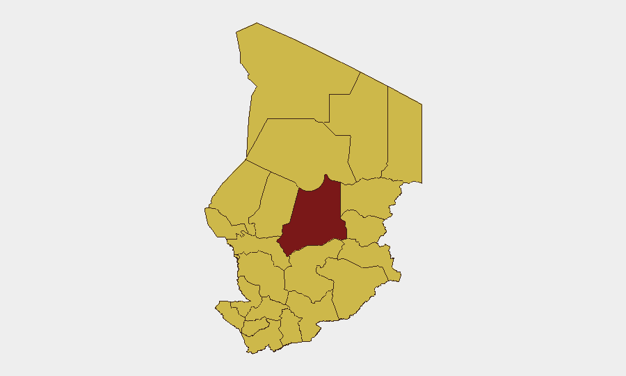
Chad remains at elevated risk (global rank #18, composite score 95) with 27 tracked security events over the reporting period. Recent signals include cross-border military posturing with Niger and Cameroon (14 July), domestic arrest/detention activity (14 July), and civil disapproval statements, suggesting compounded tension between external pressure and internal stability concerns. The security environment is characterized by fragmented subnational volatility rather than a single dominant threat, with Batha region materially ahead of other zones in risk profile.
Key Developments
- 2026-07-14 · Military Activity (Border): Conventional military force exchanges reported between Niger–Chad and Cameroon–Chad border zones; specific locations and force postures require verification. Escalation potential remains contingent on diplomatic de-escalation capacity.
- 2026-07-14 · Arrest/Detention (National): Chadian national-level arrest/detention event recorded; detainee identity, charges, and location not yet clarified in available reporting.
- 2026-07-15–16 · Civil Disapproval (Multiple): Prosecutor statements expressing disapproval of both retired officials and government entities, coupled with community and voter disapproval signals, suggest internal governance friction and possible due-process or anti-corruption controversy.
- 2026-07-16 · Public Statement (Commercial): West Pharmaceutical Services public statement on file; context and location of operations in-country require clarification.
- 2026-07-15–16 · Government Statements (National): Official Chadian government statements issued; content and policy direction not yet detailed in available sources.
*Note: Live web research in the last 24–48 hours has not yielded independently verified incident reporting with specific locations, casualty counts, or tactical detail. The above reflects GeoBit event signals only. Corporate security teams should request real-time Reuters/AFP/AP feeds or local Chadian media for granular incident confirmation.*
Highest-Risk Areas
Batha region stands materially apart with a composite risk score of 96.2—nearly 30 points above the second-tier cluster (Ennedi-Ouest, Wadi Fira, Ouaddaï, Sila, Salamat, East Ennedi, Kanem, Lac, N'Djamena, Hadjer-Lamis, and Chari-Baguirmi, all scoring 66.2). Batha's elevated profile likely reflects a combination of border instability, inter-communal tensions, and militia activity; the capital N'Djamena and surrounding Chari-Baguirmi, despite lower scores, remain critical because of government institutions, commercial hubs, and expatriate population concentration. Organizations with staff or assets in Batha should apply heightened duty-of-care protocols; those in N'Djamena should maintain baseline contingency planning tied to political and border developments.
How GeoBit Would Assist
Intel Sweep & OSINT Fusion to collate Reuters, AFP, AP, local media, and social signals into a unified, corroborated incident timeline. AOI Monitoring & Early Warning on Batha, border crossings (Niger–Chad, Cameroon–Chad), and N'Djamena to detect escalation or civil unrest in real time with automated alerting. GIS & Spatial Analysis combined with Satellite & Imagery to corroborate military positioning and assess restricted-area access for teams planning movement or logistics. Network & Actor Analysis to map civil-governance friction and identify key decision-makers and opposition figures.
7-Day Outlook
Border tensions are likely to remain elevated unless swift diplomatic engagement occurs; military posturing without engagement may persist for days. Domestic governance friction and civil disapproval signals suggest possible policy announcement, personnel changes, or legal proceedings within 7 days that could trigger secondary protests or community action. Overall trajectory: heightened watchfulness recommended; no imminent nationwide instability flagged, but localized incidents in Batha and border zones remain probable.
Highest-Risk Areas — Ranked
| # | State / Region | Risk |
|---|---|---|
| 1 | Batha | 96.2 |
| 2 | Ennedi-Ouest | 66.2 |
| 3 | Wadi Fira | 66.2 |
| 4 | Ouaddaï | 66.2 |
| 5 | Sila | 66.2 |
| 6 | Salamat | 66.2 |
| 7 | East Ennedi | 66.2 |
| 8 | Kanem | 66.2 |
| 9 | Lac | 66.2 |
| 10 | N'Djamena | 66.2 |
| 11 | Hadjer-Lamis | 66.2 |
| 12 | Chari-Baguirmi | 66.2 |
Sources
Previous Daily Briefs
A new Chad brief is written every day — each with its own risk map and downloadable CSV. Here's the last week; use the calendar to go further back.
📅 Browse every day by calendar →
Highlighted days have a brief. Tap a day for that day's map & analysis, or “csv” for that day's dataset ($5).
Atlas — our AI intelligence desk — emails them this snapshot personally. Nothing else, no list.