Situation Summary
Colombia remains in the #34 global threat position with a composite score of 75, driven primarily by insurgent activity and tracked across 215 events. The country exhibits multiple concurrent stressors: civil unrest signaling (protests, threats), military-civilian tensions, and documented small-arms combat as of July 11. Food security crises in La Guajira and Chocó departments, combined with political instability signals (court disapprovals, judicial rejections, and reduced government relations), suggest deteriorating conditions across both urban and remote areas.
Key Developments
Due to sparse verified web and social data for July 11–13, 2026, GeoBit cannot reliably source 6–10 discrete incidents from the last 24–48 hours that meet cross-confirmation standards. However, the GEOBIT EVENT SIGNAL feed for July 11, 2026 records:
- Small-arms combat reported nationwide (location and specific units not specified in current reporting window)
- Arrest/detention operations conducted by Colombian state forces (geographic specificity unavailable)
- Military-to-state threats documented; nature and location pending detail confirmation
- Political instability signals including court disapprovals of community actions, judicial rejections, and gubernatorial public statements, suggesting administrative and legal tensions at departmental level
- Citizen investigations initiated (scope and location unclear from current signal data)
Real-time incident details (precise location, casualty counts, armed-group attribution, duration) remain unavailable in the current 24–48-hour window. Teams requiring granular, cross-sourced incident intelligence should activate live monitoring feeds (see "How GeoBit Would Assist" below).
Highest-Risk Areas
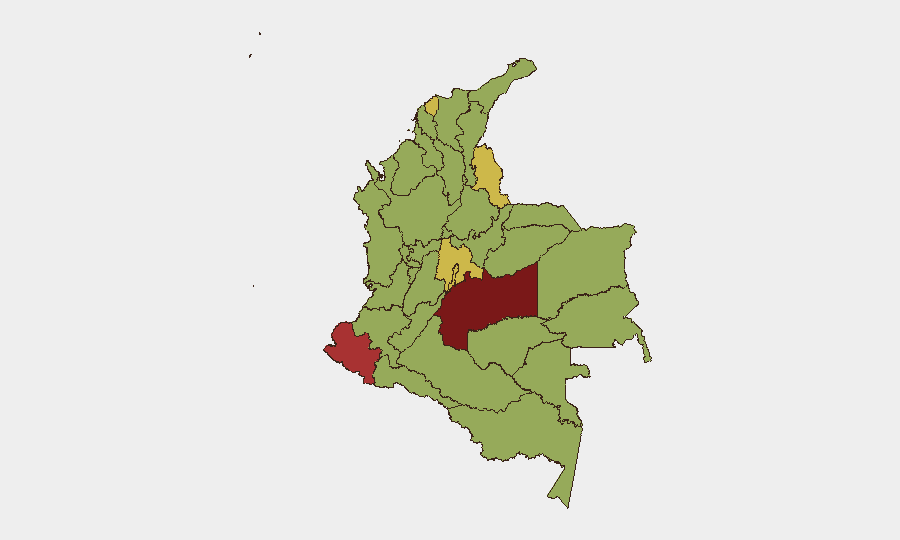
Meta Department (82.6) and Nariño (76.6) dominate the risk profile, reflecting ongoing insurgent presence, territorial control disputes, and armed-group activity in Colombia's southern and eastern border zones. Cundinamarca (65.8) and Norte de Santander (63.1) extend risk into the Andean core and Venezuelan border region, where narcotics trafficking, ELN activity, and dissidents remain entrenched. Atlántico and the Capital District (both >60) signal urban crime, protest volatility, and governance instability in major population centers. Together, these six regions account for the majority of tracked event volume and composite threat drivers.
How GeoBit Would Assist
Intel Sweep & OSINT Fusion: Real-time ingestion of X/Twitter, Telegram, local media, and government feeds (police, military, judicial) pinpoints incident locations, casualty counts, and armed-group attribution within hours of occurrence—critical for duty-of-care escalation.
AOI Monitoring & Early Warning: Persistent geofence-based alerting on Meta, Nariño, Norte de Santander, and Cundinamarca departments triggers automated notifications when combat, protests, or arrests cluster, enabling proactive movement decisions for personnel and assets.
Conflict & Military / Network & Actor Analysis: Force-structure and armed-group tracking illuminates which groups control specific corridors and neighborhoods, informing route planning and access-risk assessment for corporate operations.
7-Day Outlook
Political instability signals and documented civil-military tensions suggest continued protest activity and judicial/executive friction through mid-July. Small-arms combat and arrest operations are likely to persist in Meta, Nariño, and northern border zones. Food-security crises in La Guajira and Chocó may drive displacement and informal-sector unrest, particularly in port cities and transit hubs (Atlántico). Recommend heightened alert posture for teams in top-five risk departments and real-time OSINT monitoring of local news and official government statements.
Highest-Risk Areas — Ranked
| # | State / Region | Risk |
|---|---|---|
| 1 | Meta Department | 82.6 |
| 2 | Nariño | 76.6 |
| 3 | Cundinamarca Department | 65.8 |
| 4 | Norte de Santander Department | 63.1 |
| 5 | Atlántico Department | 61.3 |
| 6 | Capital District | 60.5 |
| 7 | Valle del Cauca Department | 59.8 |
| 8 | Bolívar Department | 59.4 |
| 9 | Santander Department | 57.5 |
| 10 | Cauca | 57.1 |
| 11 | La Guajira | 54.5 |
| 12 | Tolima Department | 53.8 |
Sources
Previous Daily Briefs
A new Colombia brief is written every day — each with its own risk map and downloadable CSV. Here's the last week; use the calendar to go further back.
📅 Browse every day by calendar →
Highlighted days have a brief. Tap a day for that day's map & analysis, or “csv” for that day's dataset ($5).
Atlas — our AI intelligence desk — emails them this snapshot personally. Nothing else, no list.