Situation Summary
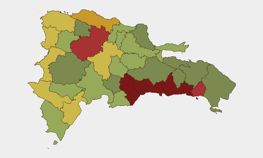
Dominican Republic remains at a composite threat level of 10 (rank #109 globally) with persistent localized violence, criminal activity, and traffic incidents concentrated in urban centers. Recent event signals show ongoing street-level homicides, organized criminal enforcement, and active law enforcement operations, primarily in Santo Domingo and Santiago provinces. The threat environment is stable but fragmented, driven by endemic gang and narcotics activity rather than systemic political or security collapse. No imminent national-level disruption is indicated, though district-level violence poses acute risk to residents and workers in high-density areas.
Key Developments
- 2026-08-05 · Homicide, Santiago – Man killed in fatal dispute over RD$50; suspect "El Sade" placed in preventive detention, indicating rapid police response and prosecution pathway.
- 2026-08-05 · Homicide, San Luis – Young male fatality during armed robbery in Sabaneta; method consistent with street-level predatory crime.
- 2026-08-05 · Homicide, San Carlos – Basketball player killed; suspect "Yeo" surrendered voluntarily to authorities, suggesting community or law-enforcement pressure.
- 2026-08-04 · Traffic Fatality, location unspecified – Sports car–motorcycle collision killed two, including one-year-old child; police investigation ongoing, underscoring high-risk road conditions.
- 2026-08-05 · Traffic Fatality, Los Ríos – Heavy vehicle struck three civilians, including a girl; classified as disaster incident, not criminal.
- 2026-08-04 · Civil Unrest, Barsequillo Hospital – Hospital-conditions protests by residents and staff; police presence noted; grievances centered on infrastructure precarity (not labor dispute or political mobilization).
*Note: Web research did not yield verified incidents within the last 24–48 hours beyond those in the GEOBIT event signal feed. Timestamps above reflect GEOBIT platform data current as of 2026-08-07.*
Highest-Risk Areas
Santo Domingo (risk 92) and Nacional District (risk 88) dominate the sub-national ranking and are the primary loci of recorded violence. San Cristóbal, San Pedro de Macorís, and La Romana form a secondary cluster of elevated risk (83–78), driven by street-level gang activity, robbery, and illicit narcotics production and trafficking. Santiago (76) and Puerto Plata (72) show sustained but lower-tier threat levels despite recent homicides. Border and rural provinces (Elías Piña, Dajabón, Independencia) register elevated risk owing to migration interdiction and clandestine smuggling networks, rather than endemic violence.
How GeoBit Would Assist
Security teams would employ OSINT fusion & corroboration to cross-reference local police bulletins, media reports, and Telegram/X channels for emerging gang activity and criminal enforcement in high-risk districts in real time. AOI monitoring & early warning on Santo Domingo, Santiago, and San Cristóbal would provide persistent alerting on protest escalation, armed clashes, or displacement events. Network & actor analysis would map street-level criminal groups and their operational territories to inform route planning and asset positioning, while routing & network analysis would generate dynamic alternative pathways for personnel and supply chains to avoid zones of acute risk.
7-Day Outlook
No indicators suggest escalation of violence to organized gang warfare or state-level instability within the next seven days. Localized street homicides and robbery will likely persist at current baseline levels in urban centers; traffic incidents will remain elevated given poor enforcement and vehicle condition. Continued Policía Nacional enforcement operations and migration interdiction at the Haitian border are expected to generate steady arrest reports and potential civilian casualties in border zones.
Highest-Risk Areas — Ranked
| # | State / Region | Risk |
|---|---|---|
| 1 | Santo Domingo | 92 |
| 2 | Nacional District | 88 |
| 3 | San Cristóbal | 85 |
| 4 | San Pedro de Macorís | 83 |
| 5 | La Romana | 78 |
| 6 | Santiago | 76 |
| 7 | Puerto Plata | 72 |
| 8 | Elías Piña | 70 |
| 9 | Dajabón | 68 |
| 10 | Barahona | 65 |
| 11 | Independencia Province | 64 |
| 12 | La Vega | 62 |
Sources
Previous Daily Briefs
A new Dominican Republic brief is written every day — each with its own risk map and downloadable CSV. Here's the last week; use the calendar to go further back.
📅 Browse every day by calendar →
Highlighted days have a brief. Tap a day for that day's map & analysis, or “csv” for that day's dataset ($5).
Atlas — our AI intelligence desk — emails them this snapshot personally. Nothing else, no list.