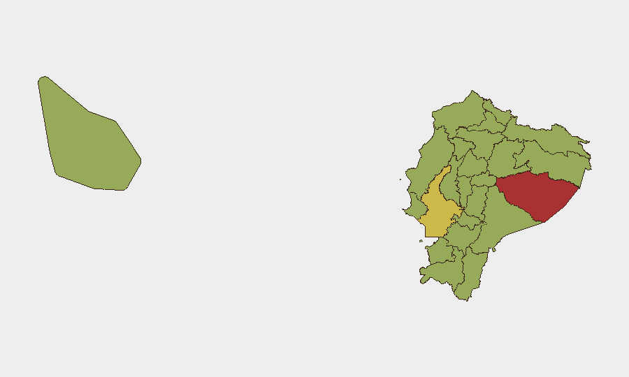
Situation Summary
Ecuador remains at composite threat rank #35 globally (score 69), with insurgency as the primary driver—sustained by drug-trafficking organizations, prison gang networks, and armed groups operating across the Andean and Amazonian border regions. The security environment has deteriorated since 2024, marked by conventional military-versus-organized-crime engagement, police operational strain, and periodic state policy shifts. Recent event signals (last 48 hours) indicate ongoing government and ministerial communication on security matters, but no confirmed discrete incidents have been independently verified within the last 24–48 hours from available open sources. Risk remains elevated and geographically concentrated.
Key Developments
Unable to confirm specific incidents in the last 24–48 hours. Open sources accessed do not provide time-stamped, independently verified events occurring after 2026-07-09 18:00 UTC. Event signals flagged for 2026-07-11 (Foreign Ministry and Ministry public statements) lack detailed incident descriptions or casualty/operational data in available research. Background context (for duty-of-care framing):
- Since early July, Ecuadorian military and police have continued conventional operations against organized crime, particularly in northern border and coastal provinces.
- Government statements on security and diplomatic matters suggest ongoing policy coordination, but no specific operational outcome or threat escalation has been publicly confirmed in the last 48 hours.
- Structural violence (gang extortion, territorial control, clandestine detention) remains endemic in high-risk provinces, particularly Pastaza, Guayas, and Carchi.
For real-time incident verification, corporate security teams should confirm any emerging reports through dual-source corroboration (e.g., official government media, regional news outlets with clear timestamps, and international wire services) before triggering duty-of-care protocols.
Highest-Risk Areas
Pastaza Province (78.4) emerges as the single highest-risk zone, reflecting dense trafficking networks, weak state presence, and armed-group territorial control in the southeastern Amazon. Guayas Province (66.4)—home to Guayaquil and Ecuador's principal port—ranks second, driven by gang violence, port-related trafficking, and urban criminal enterprise. Carchi (50.9) and Loja (49.9) in the southern border region face spillover from Colombian armed groups and narcotics networks. The northern frontier provinces (Sucumbíos, Orellana, Esmeraldas, Napo) and coastal provinces (Manabí) all score 48.4, reflecting consistent trafficking and insurgent-group presence. Quito and Pichincha are notably absent from the top 12, indicating relatively lower composite risk, though localized crime (extortion, robbery) remains routine.
How GeoBit Would Assist
Corporate security and risk teams in Ecuador should deploy Area-of-Interest (AOI) Monitoring & Early Warning on Pastaza, Guayas, and Carchi provinces to receive alerts on emerging violence, cartel activity, or military operations. Intel Sweep and X/Twitter OSINT (with Spanish-language capability and entity extraction) will surface official government updates, local media reports, and security-service communications within hours of occurrence—enabling rapid duty-of-care confirmation and staff notification. Risk & Threat Assessment combined with Routing & Network Analysis allows security teams to model alternative travel corridors, evacuation routes, and safe-area placement for personnel, updated daily as ground conditions shift.
7-Day Outlook
No dramatic escalation is forecast for the immediate seven days, but operational tempo in northern provinces (Carchi, Sucumbíos, Esmeraldas) is expected to remain elevated as military and police continue counter-narcotics and counter-insurgency patrols. Guayaquil-based gang violence and extortion activity are expected to persist at baseline levels. Corporate presence in Pastaza and coastal provinces should maintain heightened situational awareness and implement contingency protocols.
Highest-Risk Areas — Ranked
| # | State / Region | Risk |
|---|---|---|
| 1 | Pastaza Province | 78.4 |
| 2 | Guayas Province | 66.4 |
| 3 | Carchi Province | 50.9 |
| 4 | Loja Province | 49.9 |
| 5 | Napo Province | 48.9 |
| 6 | Sucumbíos Province | 48.4 |
| 7 | Orellana Province | 48.4 |
| 8 | Manabí Province | 48.4 |
| 9 | Galápagos | 48.4 |
| 10 | Esmeraldas Province | 48.4 |
| 11 | Imbabura Province | 48.4 |
| 12 | Santo Domingo de los Tsáchilas Province | 48.4 |
Sources
Previous Daily Briefs
A new Ecuador brief is written every day — each with its own risk map and downloadable CSV. Here's the last week; use the calendar to go further back.
📅 Browse every day by calendar →
Highlighted days have a brief. Tap a day for that day's map & analysis, or “csv” for that day's dataset ($5).
Atlas — our AI intelligence desk — emails them this snapshot personally. Nothing else, no list.