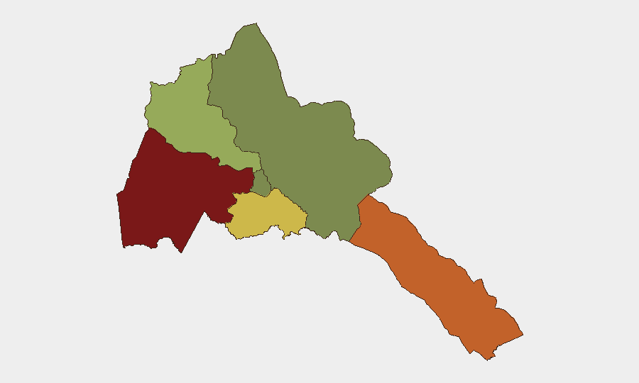
Situation Summary
Eritrea remains ranked #71 globally in composite threat (score 24), with no discrete security incidents recorded in the current 24–48-hour window. Regional tensions with Ethiopia have escalated rhetorically—President Isaias Afwerki issued a televised warning on 2026-08-14 against renewed Ethiopian aggression—but this represents political signaling rather than an active ground incident inside Eritrea. The conflict footprint remains concentrated in border regions and neighboring Tigray, Ethiopia, where fighting and drone operations near Sheraro and Shererina (dated to early August and June) indicate localized military activity; cross-border security dynamics pose latent risk to Eritrean personnel and assets in frontier zones.
Key Developments
- Regional Political Warning (2026-08-14, Eritrea nationwide): President Isaias Afwerki delivered a televised statement warning Ethiopia against launching a new military campaign, citing Eritrea's defensive capabilities and framing the dispute around Ethiopian attempts to secure a seaport. This is a political-risk signal rather than a discrete incident but indicates elevated state-level tension.
- No new confirmed ground incidents (2026-08-14 to 2026-08-15, Eritrea): No credible, location-specific security, civil-unrest, crime, or infrastructure incidents were independently confirmed within Eritrea during the past 48 hours. Open-source and wire reporting focused on regional tensions and Ethiopian/Tigrayan dynamics rather than Eritrean territory.
Highest-Risk Areas
Gash-Barka (risk 92) and the Southern Red Sea Region (risk 75) dominate the sub-national threat profile, driven by proximity to the Ethiopia–Eritrea border, cross-border militia activity, and contested territorial zones. Debub Region (risk 68) follows, reflecting exposure to regional conflict spillover and supply-route vulnerabilities. By contrast, Maekel Region (host to Asmara) registers markedly lower risk (18), indicating that capital-area security and administrative control remain relatively stable. Risk concentration in the western and southern frontier zones reflects the durability of border tensions with Ethiopia and episodic military posturing rather than active pitched warfare on Eritrean soil.
How GeoBit Would Assist
A corporate security team with personnel or assets in Eritrea should employ AOI Monitoring & Early Warning on Gash-Barka and Southern Red Sea Region to track cross-border militia movement and military repositioning, coupled with Multi-language Search and Sentiment Analysis to detect shifts in official rhetoric or diaspora reporting that may signal escalation. Conflict & Military capabilities (force-structure tracking, battle mapping, and weapons-capability assessment) provide early warning of Eritrean or Ethiopian deployments near key infrastructure or personnel locations. Routing & Network Analysis supports alternative-route planning for personnel and supply movements in high-risk frontier zones.
7-Day Outlook
Eritrea's threat profile is likely to remain stable in the immediate term (7 days), with political and military tensions persisting but no imminent indicator of renewed active conflict inside Eritrean territory. However, the rhetorical escalation on 2026-08-14 and earlier troop movements reported in early August suggest that the risk of border incidents or cross-border incursions remains elevated; any Ethiopian military action in Tigray near the Eritrean frontier carries latent spillover potential. Organizations should maintain elevated situational awareness in Gash-Barka and Southern Red Sea Region and sustain AOI monitoring for changes in military posture or cross-border movement.
Highest-Risk Areas — Ranked
| # | State / Region | Risk |
|---|---|---|
| 1 | Gash-Barka | 92 |
| 2 | Southern Red Sea Region | 75 |
| 3 | Debub Region | 68 |
| 4 | Anseba | 55 |
| 5 | Maekel Region | 18 |
| 6 | Northen Red Sea Region | 0 |
Sources
Previous Daily Briefs
A new Eritrea brief is written every day — each with its own risk map and downloadable CSV. Here's the last week; use the calendar to go further back.
- August 13, 2026
- August 11, 2026
- August 9, 2026
- August 7, 2026
- August 6, 2026
- August 5, 2026
- August 4, 2026
📅 Browse every day by calendar →
Highlighted days have a brief. Tap a day for that day's map & analysis, or “csv” for that day's dataset ($5).
Atlas — our AI intelligence desk — emails them this snapshot personally. Nothing else, no list.