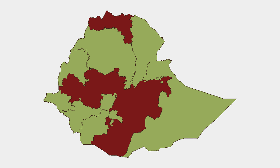
Situation Summary
Ethiopia remains in active civil conflict with composite threat score of 85 (rank #13 globally), driven by ongoing insurgency and inter-regional armed clashes. Tigray and Oromia regions are assessed at critical risk (89.4), while Amhara—historically considered relatively stable—has escalated into an active conflict zone with documented artillery strikes on civilian areas and extrajudicial killings in the past 72 hours. The conflict shows no signs of de-escalation; instead, geographic expansion of violence into previously lower-risk zones and direct attacks on critical commercial infrastructure (fuel supply, mining operations, cross-border trade routes) indicate widening destabilization.
Key Developments
- Amhara Region, East Gojjam Zone, Debre'e Eyesus town – 18 July 2026: Artillery shelling of a residential area killed a 19-year-old woman and critically wounded at least three civilians, with reports attributing the strike to government-aligned forces.
- Amhara Region, East & West Gojjam Zones (Enemay, Machakel, Bibugn, Dega-Damot, Quarit, Dembecha-Zuriya woredas) – 15–17 July 2026: Coordinated attacks involving artillery strikes on homes, documented extrajudicial executions of civilians including women and farmers, multiple injuries and mass detentions across rural communities attributed to Oromo Prosperity Party regime soldiers.
- Benishangul-Gumuz Region, Kumruk Bridge, B40 highway near Ethio-Sudan border – 17 July 2026: Strategic bridge destroyed by heavy artillery, severing a key trade and logistics corridor between Ethiopia and Sudan and creating immediate cross-border supply-chain risk.
- Benishangul-Gumuz Region, Kurmuk gold mining area – 17 July 2026: Fatal attack on mining road project; bulldozer operator killed by heavy weapon (likely RPG) after inadvertent border crossing, signaling elevated risk for commercial operations in mining and infrastructure sectors near Sudan border.
- Amhara Region, Southwestern areas (Hamus-Gebeya, Dega-Damot; Quarit Woreda) – 16–17 July 2026: Documented summary executions of women and farmers, rocket strikes killing five civilians and destroying private residences, targeted killings of two named individuals (Tesfahun Almaw, Fentahun Alemu), and wounding of three others including children.
- National fuel sector – 21–22 July 2026: TotalEnergies confirmed exit from Ethiopian downstream fuel market, with operations transferring to Libya's OLA Energy; potential for short-term supply disruptions and logistics changes affecting traveler and business operations.
Highest-Risk Areas
Tigray and Oromia remain the primary conflict epicenters (risk 89.4 each), but Amhara has escalated dramatically in the past week to become a second active theater of violence. Rural East and West Gojjam zones in particular show sustained multi-day attacks, arbitrary detention, and civilian casualties. Amhara's shift from moderate risk (59.4) trajectory to active armed conflict involving residential shelling and extrajudicial killings represents a significant expansion of the conflict footprint. Benishangul-Gumuz's proximity to the Sudan border and destruction of key infrastructure (Kumruk Bridge) adds cross-border instability and commercial-sector exposure.
How GeoBit Would Assist
Security teams would employ AOI Monitoring & Early Warning to track Amhara and Benishangul-Gumuz zones for escalation signals and alert on armed-group movement patterns. Battle Mapping and Conflict event tracking would provide real-time pinpointing of clashes and artillery activity. Routing & Network Analysis would identify alternative supply and personnel movement corridors around the destroyed Kumruk Bridge and active conflict zones, supporting duty-of-care logistics for personnel and assets in affected regions.
7-Day Outlook
Amhara Region will likely see continued artillery strikes and ground clashes given the intensity and coordination of 15–17 July attacks. Commercial infrastructure (fuel supply, mining operations, border trade routes) faces elevated disruption risk. Spillover into adjacent regions and cross-border incidents with Sudan remain probable if current trajectory persists.
Highest-Risk Areas — Ranked
| # | State / Region | Risk |
|---|---|---|
| 1 | Tigray | 89.4 |
| 2 | Oromia Region | 89.4 |
| 3 | Amhara Region | 59.4 |
| 4 | Afar Region | 59.4 |
| 5 | Benishangul-Gumuz Region | 59.4 |
| 6 | Somali Region | 59.4 |
| 7 | Gambela Region | 59.4 |
| 8 | South West Ethiopia Peoples | 59.4 |
| 9 | Addis Ababa | 59.4 |
| 10 | South Ethiopia Regional State | 59.4 |
| 11 | Central Ethiopia Regional State | 59.4 |
| 12 | Sidama | 59.4 |
Sources
Previous Daily Briefs
A new Ethiopia brief is written every day — each with its own risk map and downloadable CSV. Here's the last week; use the calendar to go further back.
📅 Browse every day by calendar →
Highlighted days have a brief. Tap a day for that day's map & analysis, or “csv” for that day's dataset ($5).
Atlas — our AI intelligence desk — emails them this snapshot personally. Nothing else, no list.