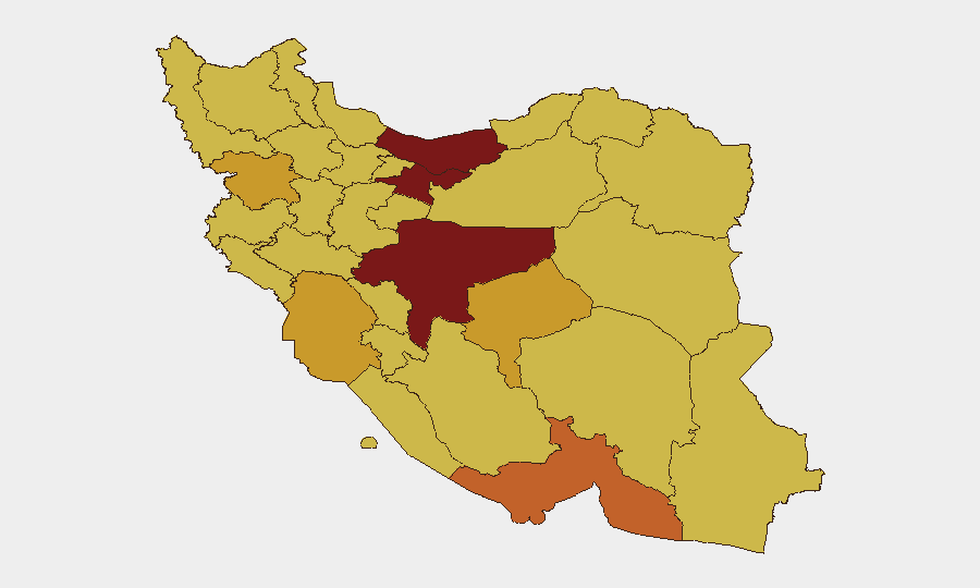
Situation Summary
Iran faces acute regional military tension stemming from reciprocal strikes between Iranian forces and U.S./allied military assets across the Gulf, initiated by Iranian drone attacks on commercial shipping and Gulf facilities over the past 48 hours. Domestic security incidents inside Iran proper remain absent from open reporting in this immediate window, but the volatile external environment—coupled with persistent restrictions on travel and communications—elevates overall risk for personnel and assets in-country. The situation remains fluid, with both Iranian and U.S. officials signaling capacity for rapid escalation, and civilian infrastructure (air routes, telecom, power) faces documented disruption risk.
Key Developments
- Strait of Hormuz (Oman coast) – Thursday, 27–28 June
Singapore-flagged commercial vessel struck by Iranian drone in the shipping lane; U.S. officials confirmed Iranian origin and launched retaliatory airstrikes on Iranian military targets in response.
- Bahrain – Saturday, 29 June
IRGC conducted multi-drone assault on several Bahrain locations, claiming U.S. Fifth Fleet facilities as targets; Bahrain Foreign Ministry confirmed Iranian drone activity and designated it a threat to citizen security.
- Kuwait (Ali al-Salem Air Base) – Sunday, 30 June
IRGC announced drone and missile strikes on U.S. military positions; U.S. Central Command acknowledged reciprocal airstrikes on Iranian targets, confirming ongoing tit-for-tat operations across the Gulf.
- Persian Gulf (regional) – Saturday–Sunday, 29–30 June
U.S. military reported new strikes against approximately 10 Iranian military targets; IRGC claimed destruction of eight U.S. facilities, though independent verification found no major damage or U.S. casualties.
- Strait of Hormuz traffic management – Sunday, 30 June
U.S. Navy-overseen maritime body expanded protected shipping corridor to accommodate bidirectional traffic, directly responding to recent drone and projectile incidents and signaling structural change in route security protocols.
- Canadian travel advisory – updated within 48 hours
Government reiterated directive to avoid all travel to Iran; advisory cites heightened risk of military activity resumption on short notice, with potential for flight cancellations, telecom blackouts, and power outages.
Highest-Risk Areas
Tehran Province (risk 100) and Isfahan Province (risk 94) drive Iran's composite threat score, followed by Mazandaran, Hormozgan, and Kurdistan provinces (risk 72–82). Risk concentration in Tehran reflects both capital-city exposure to political volatility and security operations, while Isfahan's industrial and economic footprint elevates consequences of any civil unrest or infrastructure targeting. Southern Gulf-proximate provinces (Hormozgan, Khuzestan, Bushehr) face elevated risk due to proximity to active military operations and maritime chokepoints, creating cascading effects on logistics and civilian movement. Northern provinces (Kurdistan, East Azerbaijan) show persistent risk tied to border instability and historical protest activity.
How GeoBit Would Assist
Security teams should deploy AOI Monitoring & Early Warning on Tehran, Isfahan, and Hormozgan provinces to detect civil unrest, checkpoints, or force movements affecting personnel movement or supply chains. Maritime & Aviation tracking combined with Routing & Network Analysis capabilities enable real-time alternate-route planning around Strait of Hormuz disruptions and flight-corridor closures. Multi-language OSINT fusion (X, Telegram, local news) and sentiment analysis on Iranian regime and IRGC messaging provide 24–48-hour early warning of domestic crackdowns or infrastructure shutdowns before they cascade to foreign nationals.
7-Day Outlook
Reciprocal Iran–U.S. military activity is likely to continue or escalate through early July, with no clear off-ramp signaled by either side. Domestic security inside Iran is expected to remain stable absent major political shock, but telecommunications and power disruptions tied to military operations may increase. Risk to non-essential travel and supply-chain continuity remains elevated; essential personnel should maintain heightened readiness-to-relocate posture.
Highest-Risk Areas — Ranked
| # | State / Region | Risk |
|---|---|---|
| 1 | Tehran Province | 100 |
| 2 | Isfahan Province | 94 |
| 3 | Mazandaran Province | 81.6 |
| 4 | Hormozgan Province | 74.6 |
| 5 | Kurdistan Province | 72.8 |
| 6 | Yazd Province | 72.1 |
| 7 | Khuzestan Province | 71.2 |
| 8 | Razavi Khorasan | 70.9 |
| 9 | East Azerbaijan Province | 70.9 |
| 10 | Bushehr Province | 70.8 |
| 11 | Kohgiluye and Buyer Ahmad Province | 70.4 |
| 12 | North Khorasan Province | 70 |
Sources
Previous Daily Briefs
A new Iran brief is written every day — each with its own risk map and downloadable CSV. Here's the last week; use the calendar to go further back.
📅 Browse every day by calendar →
Highlighted days have a brief. Tap a day for that day's map & analysis, or “csv” for that day's dataset ($5).