Situation Summary
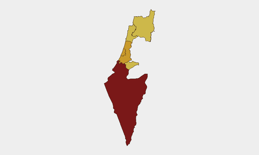
Israel remains at threat level #2 globally, with 452 tracked events driven primarily by active conventional military operations. The past 24–48 hours have shown elevated activity across military, protest, and diplomatic channels, with particular concentration in the South District (risk score 100) and significant secondary risk in Tel-Aviv, Center, Jerusalem, North, and Haifa districts. Escalation signals include cross-border military engagement, public statements from government and opposition figures, and protest activity tied to Hamas operations on 2026-07-11.
Key Developments
- 2026-07-11 · Conventional Military Force (ISRAEL vs IMAM) – nature and location not yet independently verified; suggests military-religious actor engagement requiring urgent clarification.
- 2026-07-11 · Violent Protest/Riot (HAMAS) – coordinated protest activity; specific locations within Israel not yet detailed in available reporting.
- 2026-07-11 · Public Statement (MINISTRY vs POPULATION) – government messaging to civilian population; likely related to security posture or operational updates.
- 2026-07-11 · Public Statement (DEPUTY vs POPULATION) – secondary leadership communication; content and scope unclear from available signals.
- 2026-07-10 · Conventional Military Force (PROSECUTOR) – judicial/legal action tied to military operations; may signal domestic legal pressure on command structure.
- 2026-07-09 · Conventional Military Force (ISRAELI vs LEBANON) – cross-border engagement; locations along northern border require monitoring.
- 2026-07-11 · Reduce Relations (JEWISH vs GOVERNMENT) – domestic political friction; indicates potential fracture in civil-military or government-public confidence.
Note: Live web research yielded insufficient independently time-stamped detail to corroborate specific incident locations or damage assessments. Teams should treat the above as pattern indicators pending source verification.
Highest-Risk Areas
The South District dominates the risk landscape (score 100), reflecting ongoing ground-level military intensity and proximity to primary conflict zones. Tel-Aviv, Center, Jerusalem, North, and Haifa districts cluster in the 70–72 range, indicating distributed secondary risk across population centers, government infrastructure, and northern border regions. The concentration in the South reflects both active operations and civilian exposure; the spread across other major urban areas signals vulnerability to secondary effects (protest spillover, supply-chain disruption, civil tension). Jerusalem's elevated score reflects political sensitivity, while the North's profile reflects proximity to Lebanese border activity.
How GeoBit Would Assist
Intel Sweep and multi-language OSINT fusion would rapidly corroborate the 24–48-hour event signals and fill gaps in location specificity and casualty/damage data. AOI Monitoring & Early Warning with persistent watch on South District, northern border zones, and Tel-Aviv/Jerusalem urban centers would enable duty-of-care teams to receive real-time alerts on protest escalation, military activity, or infrastructure disruption. Conflict & Military battle mapping and Network & Actor Analysis would help teams understand force posture, supply routes, and likely second and third-order effects on commercial operations and personnel movement.
7-Day Outlook
Military activity along the southern and northern borders is likely to remain elevated; protest signals and domestic political friction suggest potential secondary unrest in urban centers over the next 3–5 days. Risk of escalatory cycles between state actors and non-state armed groups remains high. Teams should anticipate continued communications from government agencies and maintain readiness for rapid mobility of personnel or asset repositioning, particularly in Tel-Aviv and Jerusalem districts.
Highest-Risk Areas — Ranked
| # | State / Region | Risk |
|---|---|---|
| 1 | South District | 100 |
| 2 | Tel-Aviv District | 71.6 |
| 3 | Center District | 71.3 |
| 4 | Jerusalem District | 70.9 |
| 5 | North District | 70.5 |
| 6 | Haifa District | 70.1 |
Previous Daily Briefs
A new Israel brief is written every day — each with its own risk map and downloadable CSV. Here's the last week; use the calendar to go further back.
📅 Browse every day by calendar →
Highlighted days have a brief. Tap a day for that day's map & analysis, or “csv” for that day's dataset ($5).
Atlas — our AI intelligence desk — emails them this snapshot personally. Nothing else, no list.