Situation Summary
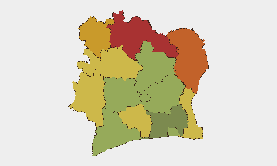
Ivory Coast remains a mid-tier global security concern (rank #60, composite score 32) with no tracked events in the past 24–48 hours. The northern and northeastern districts—Savanes, Zanzan, Denguélé, and Comoé—represent the primary threat zones, driven by transnational smuggling networks, porous borders, and historical communal tensions. The country's overall stability trajectory is steady, though localized crime and impersonation schemes (including recent police impostor assaults) warrant continued attention in transit corridors.
Key Developments
- 2026-08-30 | Tanda (Zanzan District) | Criminal Impersonation & Theft. Three individuals impersonating Police Nationale/FDS officers robbed travelers at the entrance to Tanda, seizing 75,000 CFA francs. This incident underscores organized fraud targeting inter-city routes in a high-risk northern district and suggests coordination with or exploitation of security-uniform access.
No additional confirmed, location-specific security incidents within Ivory Coast were identified in the final 24–48 hours of reporting (through 2026-09-02). Web searches returned archived or non-Ivorian material (e.g., Niger-focused reporting dateline Abidjan, older cargo-incident articles). Routine regulatory announcements (tax administration e-invoicing) do not constitute security developments.
Highest-Risk Areas
Savanes, Zanzan, Denguélé, and Comoé districts (risk scores 78–70) dominate the threat landscape, concentrated in the northern and northeastern frontier belt. These zones are characterized by cross-border trafficking (arms, contraband, persons), weak state presence, and historical intercommunal disputes that periodically flare into roadblocks and localized violence. Montagnes and Woroba districts (68, 65) represent secondary concern zones. By contrast, the southern coastal belt and Abidjan itself (risk 45) face primarily street-level crime and petty theft rather than organized conflict or governance collapse.
How GeoBit Would Assist
Corporate security teams should deploy AOI Monitoring & Early Warning on Savanes, Zanzan, and Denguélé districts to flag roadblocks, checkpoint violence, and trafficking activity before impact on supply chains or personnel movement. Routing & Network Analysis can identify safer alternative corridors and real-time journey planning around high-risk northern checkpoints. OSINT fusion (multi-language web scraping, social-media geolocation filtering, and cross-checking against Ivorian police/gendarmerie communiqués) will close the current 24–48-hour intelligence gap and surface emerging protests, infrastructure disruptions, or organized crime shifts faster than public news cycles.
7-Day Outlook
No significant escalation is anticipated over the next week; the country remains in a steady-state posture with baseline street crime and northern smuggling activity. However, the frequency of police-impostor schemes suggests organized criminal networks are becoming more brazen in northern transit zones, which may signal a shift toward more coordinated extortion or banditry. Personnel and asset movement through Savanes and Zanzan districts should be flagged for enhanced due diligence and real-time tracking.
Highest-Risk Areas — Ranked
| # | State / Region | Risk |
|---|---|---|
| 1 | Savanes District | 78 |
| 2 | Zanzan District | 75 |
| 3 | Denguélé District | 72 |
| 4 | Comoé District | 70 |
| 5 | Montagnes District | 68 |
| 6 | Woroba District | 65 |
| 7 | Gôh-Djiboua District | 60 |
| 8 | Sassandra-Marahoué District | 58 |
| 9 | Vallée du Bandama District | 55 |
| 10 | Bas-Sassandra District | 52 |
| 11 | Lacs District | 48 |
| 12 | Abidjan | 45 |
Sources
Previous Daily Briefs
A new Ivory Coast brief is written every day — each with its own risk map and downloadable CSV. Here's the last week; use the calendar to go further back.
- September 1, 2026
- August 31, 2026
- August 30, 2026
- August 28, 2026
- August 26, 2026
- August 25, 2026
- August 23, 2026
📅 Browse every day by calendar →
Highlighted days have a brief. Tap a day for that day's map & analysis, or “csv” for that day's dataset ($5).
Atlas — our AI intelligence desk — emails them this snapshot personally. Nothing else, no list.