Situation Summary
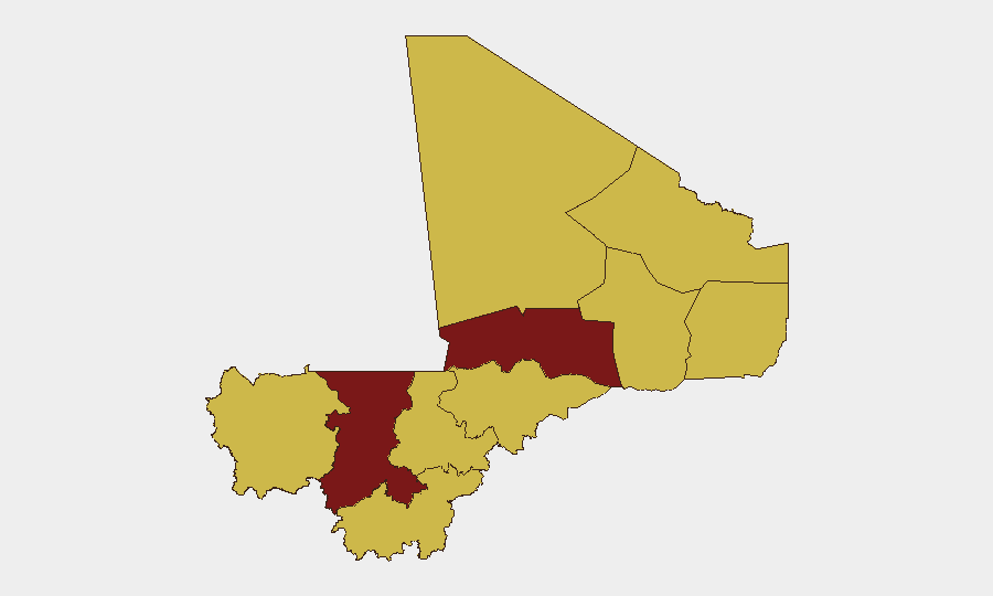
Mali remains at elevated composite threat level (rank #11 globally, score 99) amid ongoing instability across the Sahel. The most recent signal activity (June 29–July 1) reflects a mix of political statements, military engagements, and reported abductions, though ground-truth verification of specific incidents within the past 24–48 hours is not available from open sources. Koulikoro Region has emerged as the highest-risk sub-national zone (99.4), followed by Timbuktu (92.4) and Bamako (71.7), indicating concentrated threat density in the northwest and capital. Overall trajectory remains volatile, with no near-term de-escalation indicators.
Key Developments
- June 29–July 1 Signal Activity: GeoBit event feeds flagged 11 distinct signals across the period, including public statements from military and government actors, one unconventional-violence attribution to Iran, and multiple abduction/hostage incidents linked to non-state groups (including Somalia-attributed actors). None have been independently corroborated with specific time-stamped incident reports from major wire services or humanitarian bodies as of July 1, 0600 UTC.
- Military vs. Non-State Engagements (June 30): Signal data indicated conventional military force and small-arms combat between Mali National Guard units and a non-state fighter element; geography and casualty figures remain unconfirmed pending source consolidation.
- Governance Friction (June 30): Public disapproval statements attributed to Mali government actors suggest internal policy or leadership disagreement; context and implications require ongoing OSINT corroboration.
- Abduction/Hostage Reporting (June 30, multiple): Two separate abduction or hostage-taking signals were flagged; attribution to Somalia-based actors and locations remain unverified and require cross-reference with MINUSMA, UN OCHA, or NGO alert channels.
- Historical Context (April–May 2026): Human Rights Watch and other sources documented grave abuses, multi-week sieges, and airstrikes in northern regions during spring; these incidents are *not* current developments but establish the broader operational environment driving persistent threat levels in Koulikoro, Timbuktu, and surrounding zones.
Highest-Risk Areas
Koulikoro Region dominates the sub-national risk ranking (99.4) and serves as the primary threat driver for the country composite score, likely reflecting ongoing armed-group presence, intercommunal tensions, and limited state security capacity. Timbuktu (92.4) follows, consistent with long-standing Sahel insurgent activity and supply-line vulnerabilities. Bamako (71.7), the capital and primary corporate/expatriate hub, carries elevated risk due to governance instability, insider-threat vectors, and secondary effects of regional conflicts. The remaining nine regions cluster at 69.4, indicating a broadly dispersed but lower-intensity secondary threat layer across the south and east; however, this does not imply safety—it reflects relative concentration of violence signals in the north and northwest.
How GeoBit Would Assist
Security teams should employ AOI Monitoring & Early Warning to maintain persistent watch over Koulikoro and Timbuktu with real-time alerting on military movements, armed-group communications, and abduction/hostage signals. OSINT fusion & corroboration (multi-language feeds, X/Telegram OSINT, regional media analysis) will disambiguate rumor from confirmed incident and reduce false-positive response. Network & Actor Analysis can map non-state group leadership, supply chains, and ransom/hostage dynamics to inform duty-of-care protocols and staff movement decisions in high-risk zones.
7-Day Outlook
No significant de-escalation is anticipated in the next 7 days. Military and non-state actor signals are expected to persist at current levels; abduction risk in the northwest remains elevated. Organizations with personnel or assets in Koulikoro, Timbuktu, and Bamako should maintain heightened posture and daily briefings from real-time OSINT feeds.
Highest-Risk Areas — Ranked
| # | State / Region | Risk |
|---|---|---|
| 1 | Koulikoro | 99.4 |
| 2 | Timbuktu | 92.4 |
| 3 | Bamako | 71.7 |
| 4 | Ménaka | 69.4 |
| 5 | Kayes | 69.4 |
| 6 | Taoudénit Region | 69.4 |
| 7 | Kidal | 69.4 |
| 8 | Gao | 69.4 |
| 9 | Ségou Region | 69.4 |
| 10 | Sikasso Region | 69.4 |
| 11 | Mopti | 69.4 |
Sources
Previous Daily Briefs
A new Mali brief is written every day — each with its own risk map and downloadable CSV. Here's the last week; use the calendar to go further back.
📅 Browse every day by calendar →
Highlighted days have a brief. Tap a day for that day's map & analysis, or “csv” for that day's dataset ($5).