Situation Summary
Myanmar remains in a sustained high-threat environment with a composite national threat score of 92/100 and no discernible de-escalation pathway as of 30 June 2026. Active conventional military operations between junta forces and armed resistance groups continue across central and border regions, accompanied by elevated cross-border tension with Thailand and concurrent environmental hazards (flooding) that restrict movement and compound civilian risk. The threat landscape is assessed as unstable, with fighting expected to persist in key operational zones through the immediate term.
Key Developments
- Myawaddy Township, Kayin State (29 June 2026): Active cross-border shelling reported near the Thai frontier, with Myanmar military artillery impacting areas close to Thailand, prompting public statements by Thai authorities on border security concerns and spillover risk.
- Central Myanmar / Magway Region (29 June 2026): Confirmed conventional military operations by government forces against resistance elements; Magway Region identified as the highest-risk sub-national area nationally, indicating intensive junta combat activity in that zone.
- Thailand–Myanmar Border (29 June 2026): Two separate public statements issued by Thai authorities regarding border security and the Myanmar conflict, signaling heightened diplomatic concern over cross-border incident activity and refugee/IDP pressures.
- Multiple regions, Myanmar (late June 2026): Flooding events documented across the country in recent days, restricting road access and complicating supply-chain and personnel-movement options in conflict-affected areas; assessed as concurrent environmental hazard alongside active fighting.
- Central interior regions / Anyar area (through 30 June 2026): Continued intensive use of airstrikes and artillery by junta forces against resistance positions, with documented village destruction and ongoing disruption of civilian movement corridors; remains a high-risk travel environment.
Highest-Risk Areas
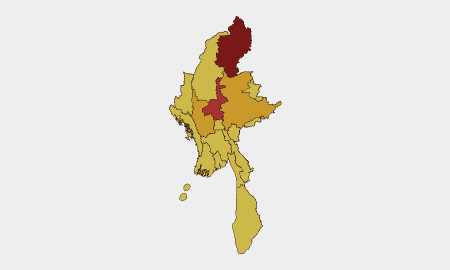
Kachin State (95.2) and Mandalay (77.9) drive the highest risk scores, followed by Shan State (71.9) and Magway (71.0). Kachin's extreme risk reflects sustained armed-group activity and limited state control; Mandalay's score reflects proximity to multiple conflict zones and dense urban population. Magway's recent elevation in operational intensity—driven by confirmed 29 June fighting—underpins its position as the highest-risk central region. Border regions (Kayin, Sagaing, Tanintharyi) and ethnic-minority areas (Chin, Wa State, Rakhine) remain chronically destabilized; Yangon and Naypyitaw carry moderate baseline risk but remain susceptible to spillover violence and targeted activity.
How GeoBit Would Assist
Corporate security and duty-of-care teams would deploy AOI Monitoring & Early Warning on Magway Region and key border townships (Myawaddy, Kayin) to detect clashes and cross-border shelling in near-real time, coupled with Routing & Network Analysis to identify safe alternative movement corridors as flooding and fighting restrict primary routes. Conflict & Military battle mapping and OSINT fusion (X/Twitter, Telegram, open radio SIGINT) would provide continuous visibility of junta and resistance force positions, while Satellite & Imagery analysis would confirm damage, displacement, and movement patterns in central regions. Sentiment & temporal analysis of Thai and Myanmar official statements would flag escalating diplomatic risk before operational spillover.
7-Day Outlook
Conventional military operations in Magway and surrounding central regions are forecast to continue without significant pause through early July, with cross-border tension along the Thailand frontier remaining elevated. Flooding is expected to recede gradually, but cumulative effect on transport networks will persist. No indicators of imminent ceasefire or major force realignment are present; threat environment remains at sustained high alert.
Highest-Risk Areas — Ranked
| # | State / Region | Risk |
|---|---|---|
| 1 | Kachin State | 95.2 |
| 2 | Mandalay | 77.9 |
| 3 | Shan State | 71.9 |
| 4 | Magway | 71 |
| 5 | Sagaing Region | 65.9 |
| 6 | Tanintharyi Region | 65.2 |
| 7 | Chin | 65.2 |
| 8 | Wa State (Northern Region) | 65.2 |
| 9 | Rakhine | 65.2 |
| 10 | Ayeyarwady | 65.2 |
| 11 | Yangon | 65.2 |
| 12 | Naypyitaw Union Territory | 65.2 |
Sources
Previous Daily Briefs
A new Myanmar brief is written every day — each with its own risk map and downloadable CSV. Here's the last week; use the calendar to go further back.
📅 Browse every day by calendar →
Highlighted days have a brief. Tap a day for that day's map & analysis, or “csv” for that day's dataset ($5).