Situation Summary
Nigeria remains the world's second-highest composite threat environment, driven primarily by active insurgency, banditry, and kidnap-for-ransom networks across northern and central regions. The past 48 hours have brought a catastrophic natural-disaster overlay—flash flooding in Niger State with confirmed deaths exceeding 151 and potential tolls approaching 700—compounding already-strained security and emergency-response capacity. Concurrent incidents across Katsina, Edo, Kano, Kwara, and Kogi states demonstrate the persistence of kidnapping, rustling, and armed-bandit operations despite active security-force countermeasures. The security landscape remains volatile and fragmented by geography, with no indication of imminent systemic de-escalation.
Key Developments
- Mokwa, Niger State (5 July 2026): Flash flooding killed at least 151 people with approximately 700 feared dead across the wider corridor; search-and-recovery operations ongoing, with authorities no longer expecting to find survivors. Displaced populations number in the hundreds, with extensive damage to homes and critical infrastructure reported.
- Katsina State highway (4 July 2026): Armed bandits abducted nine travellers on an inter-state transit route, consistent with active kidnap-for-ransom operations targeting highway corridors in the north.
- Edo State (4 July 2026): Police mass-arrest operation netted 45 suspects and rescued 38 abducted victims in a single enforcement action, indicating both significant criminal networks and active state security response.
- Kano State hospital (4 July 2026): Armed thieves fatally wounded a hospital security guard during theft of solar power equipment, illustrating lethal crime targeting essential health-care infrastructure.
- Kwara State forest area (4 July 2026): Security forces foiled a kidnap plot and rescued a woman and her two-year-old child from a forest location, underscoring ongoing rural abduction activity and tactical police intervention.
- Kogi State livestock corridor (early 5 July 2026): Security forces recovered approximately 1,000 rustled livestock during an anti-bandit operation, disrupting organised rustling networks.
- Borno State (4 July 2026): Federal Government flagged off road-infrastructure projects valued at N137 billion aimed at reopening trade corridors and improving mobility and security in the insurgency-affected northeast.
Highest-Risk Areas
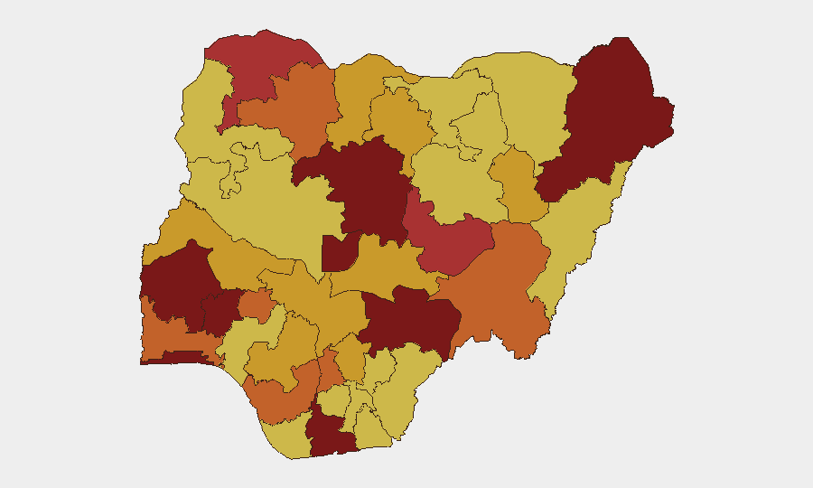
Kaduna State (risk 100) dominates the sub-national threat ranking, followed by Osun (90.1), Oyo (88.3), Borno (83.4), and Rivers (82.1). The concentration of risk in the north-central corridor—Kaduna, Katsina, Kogi, Kwara, Kano—reflects sustained banditry, kidnapping, and rustling activity; Borno's ranking reflects ongoing Boko Haram and splinter-group insurgency. Osun and Oyo in the southwest and Rivers in the southeast indicate spreading crime-network pressure and community-level instability outside the traditional insurgency zones. The Federal Capital Territory (81.3) and Lagos (80) rank within the top 10, signalling that even major urban and administrative centres face material risk from criminal enterprise and organised violence.
How GeoBit Would Assist
Corporate security and duty-of-care teams would employ AOI Monitoring & Early Warning to track persistent threats in Kaduna, Borno, and Rivers states in real time; Routing & Network Analysis to identify safe alternative transit corridors for staff and supply chains; and OSINT fusion (X/Telegram feeds, open-source event tracking, multi-language sentiment analysis) to detect emerging kidnap-for-ransom targeting patterns and bandit-movement signals before incidents occur. Risk & Threat Assessment and conflict mapping enable scenario planning and site-hardening prioritisation in the highest-risk sub-national zones.
7-Day Outlook
Flooding impact in Niger State will likely persist as a secondary humanitarian and security drain on state resources over the next week, reducing emergency-response capacity elsewhere. Bandit and kidnapping activity across the north-central corridor is expected to remain elevated through the seasonal period; no imminent policy or security-force shift is signalled. Monitoring for secondary displacement, supply-chain disruption, and organised-crime opportunism in flood-affected areas is warranted.
Highest-Risk Areas — Ranked
| # | State / Region | Risk |
|---|---|---|
| 1 | Kaduna State | 100 |
| 2 | Osun State | 90.1 |
| 3 | Oyo State | 88.3 |
| 4 | Borno State | 83.4 |
| 5 | Rivers State | 82.1 |
| 6 | Federal Capital Territory | 81.3 |
| 7 | Lagos State | 80 |
| 8 | Benue State | 80 |
| 9 | Plateau State | 76.5 |
| 10 | Sokoto State | 76 |
| 11 | Ogun State | 75.8 |
| 12 | Zamfara State | 74.9 |
Sources
Previous Daily Briefs
A new Nigeria brief is written every day — each with its own risk map and downloadable CSV. Here's the last week; use the calendar to go further back.
📅 Browse every day by calendar →
Highlighted days have a brief. Tap a day for that day's map & analysis, or “csv” for that day's dataset ($5).
Atlas — our AI intelligence desk — emails them this snapshot personally. Nothing else, no list.