Situation Summary
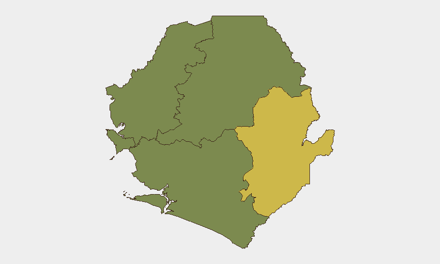
Sierra Leone remains a low-to-moderate threat environment (global rank #97) with no verified major security incidents in the past 24–48 hours. The country's composite threat score of 14 reflects routine law-enforcement activity, localized narcotics operations, and heightened diplomatic posture around the ongoing ECOWAS summit in Lungi. Risk is heavily concentrated in the Eastern Province, where governance capacity and weapons circulation remain concerns.
Key Developments
- Freetown International Airport, Lungi – 21 July 2026: Civil Aviation Authority activated a 20-km drone-detection perimeter and banned unauthorized drone operations ahead of the ECOWAS mid-year statutory meetings. No incidents reported; measure is precautionary and orderly.
- ECOWAS Summit, Lungi – 21 July 2026: Regional leaders issued a communique calling for Guinea's full withdrawal from disputed border enclaves at Yenga and Lofa (Kailahun/Lofa border area). Reflects ongoing diplomatic management of longstanding border friction; no clashes reported in the last 48 hours.
- Mile 38 checkpoint, Freetown–interior corridor – 19 July 2026: Joint Sierra Leone Police and Armed Forces team arrested one suspect with nine cannabis wraps during routine vehicle search. Illustrates sustained checkpoint presence on key transit routes.
- Political and institutional messaging – 22–23 July 2026: Multiple public statements exchanged between President Julius Maada Bio and ECOWAS, as well as statements from criminal-justice and UN actors on governance matters. No evidence of imminent institutional breakdown; reflects ongoing political discourse.
- Eastern Province police reinforcement – July 2026: Sierra Leone Police deployed 74 newly trained officers across Kenema and other Eastern Region divisions to strengthen community safety. Indicates official assessment of capacity gaps in the east rather than response to a specific acute crisis.
Highest-Risk Areas
Eastern Province dominates the sub-national risk landscape (score 68), driven by weaker governance capacity, weapons circulation (evidenced by the Ferry Junction rifle seizure on 16 July), and sustained narcotics trafficking. Western Area (score 35) remains the second-priority zone, reflecting urban crime and checkpoint-level security concerns in and around Freetown. Northern, North West, and Southern provinces show zero assigned risk in GeoBit's current model, indicating either lower-priority monitoring or absence of significant tracked events in those regions. The concentration of risk in the east suggests that inland routes, border areas, and Kono/Kenema divisions warrant closer attention for organizations with personnel or supply chains in those zones.
How GeoBit Would Assist
Security teams operating in Sierra Leone should use AOI Monitoring & Early Warning to track the Eastern Province continuously and receive alerts on incidents (weapons, organized crime, civil unrest) before they escalate to national significance. OSINT Fusion & Corroboration across X/Twitter, Telegram, and local news feeds will track political statements and institutional messaging for early signs of governance instability or regime-level shifts. Routing & Network Analysis can identify safer transit corridors and checkpoint locations on the Freetown–interior highway in real time, reducing exposure to weapons/narcotics checkpoints or interdiction.
7-Day Outlook
The ECOWAS summit will likely conclude by end-of-week without major incident; heightened airport security will persist through the meetings. Routine narcotics and weapons enforcement will continue at checkpoints, particularly along the Mile 38 corridor and in Kono District. No indicators of large-scale civil unrest, coup activity, or cross-border military action are evident in open-source reporting, though border tensions with Guinea remain a latent risk requiring diplomatic monitoring.
Highest-Risk Areas — Ranked
| # | State / Region | Risk |
|---|---|---|
| 1 | Eastern Province | 68 |
| 2 | Western Area | 35 |
| 3 | North West Province, Sierra Leone | 0 |
| 4 | Northern Province, Sierra Leone | 0 |
| 5 | Southern Province, Sierra Leone | 0 |
Sources
Previous Daily Briefs
A new Sierra Leone brief is written every day — each with its own risk map and downloadable CSV. Here's the last week; use the calendar to go further back.
📅 Browse every day by calendar →
Highlighted days have a brief. Tap a day for that day's map & analysis, or “csv” for that day's dataset ($5).
Atlas — our AI intelligence desk — emails them this snapshot personally. Nothing else, no list.