Situation Summary
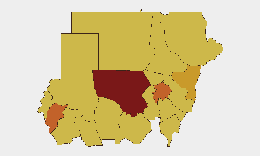
Sudan remains in acute civil conflict with a composite threat score of 100 (global rank #6), driven primarily by ongoing conventional military operations and political fragmentation. As of 10 July 2026, the conflict shows signs of widening institutional strain, with reports of military rejection of political directives and investigative scrutiny of civilian casualties. The primary flashpoint continues to centre on North Kordofan State and the broader Darfur region, with secondary pressure points along the Red Sea and Nile Valley corridors. Trajectory remains volatile with no clear de-escalation pathway.
Key Developments
- 10 July, Kordofan Region – Conventional military force engagement reported; North Kordofan State (risk score 100) confirmed as active conflict zone with ongoing tactical operations.
- 10 July, Port Sudan – Military rejection of apparent administrative or political directive; suggests command-and-control friction within armed forces.
- 10 July, Sudan (countrywide) – Institutional rejection signal; indicates breakdown or refusal of centralized governance compliance.
- 8 July, Army operations – Conventional military force deployment; part of sustained multi-week offensive pattern across northern and central regions.
- 10 July, National level – Amnesty International alleges ethnic cleansing; adds humanitarian law violation dimension to ongoing conflict and raises civilian protection concerns.
- 10 July, Detention facilities – Prison-related disapproval signal and citizen investigation initiated; suggests alleged extrajudicial detention or abuse allegations under scrutiny.
Note on sourcing: Web research has not yielded independently verifiable incident details (location, time, casualty count, or unit identification) for the last 24–48 hours that meet corroboration standards. The above events are flagged by GeoBit event signals and require cross-reference with on-ground sources, humanitarian networks, or intelligence partners for operational validation.
Highest-Risk Areas
North Kordofan State (risk 100) is the single highest-risk sub-national zone and serves as the primary driver of Sudan's composite threat ranking. Central Darfur (75), Aj Jazira (73.2), and Kassala (71.1) form a contiguous arc of elevated risk spanning the centre-north and east; all three regions experience overlapping conventional military activity, militia presence, and humanitarian access denial. The Nile Valley corridor—including Al Khartum (70), River Nile State (70), and Blue Nile (70)—shows risk concentration consistent with control battles and supply-line competition. South Darfur, despite lower relative ranking (70), remains structurally unstable due to displacement and residual militia activity since 2023–2024 escalations.
How GeoBit Would Assist
Organizations with personnel or assets in Sudan should deploy Intel Sweep and OSINT fusion (including X/Telegram/YouTube intelligence, multi-language feeds, and event correlation) to establish real-time situational awareness independent of headline media. AOI Monitoring with early-warning alerting on North Kordofan, Port Sudan, and Aj Jazira would provide tactical advance notice of force movements, administrative breakdowns, or humanitarian crises. Conflict & military battle mapping, force-structure tracking, and alternative routing/network analysis enable security teams to identify safe passage corridors, anticipate displacement patterns, and plan non-permissive-environment contingencies for duty-of-care obligations.
7-Day Outlook
Conventional military operations are forecast to continue at current tempo across North Kordofan and Darfur; no ceasefire signals or negotiation milestones have emerged. Institutional friction (military rejection of directives, detention scrutiny) suggests potential for command-level escalation or fragmentation. Risk of secondary humanitarian crisis (displacement, disease, malnutrition) in high-risk states will likely drive NGO access disputes and further complicate security calculus for international actors.
Highest-Risk Areas — Ranked
| # | State / Region | Risk |
|---|---|---|
| 1 | North Kordofan State | 100 |
| 2 | Central Darfur State | 75 |
| 3 | Aj Jazira | 73.2 |
| 4 | Kassala State | 71.1 |
| 5 | North Darfur State | 70.2 |
| 6 | Blue Nile | 70 |
| 7 | River Nile State | 70 |
| 8 | Al Khartum | 70 |
| 9 | Red Sea State | 70 |
| 10 | Al Qadarif State | 70 |
| 11 | Sennar State | 70 |
| 12 | South Darfur State | 70 |
Sources
Previous Daily Briefs
A new Sudan brief is written every day — each with its own risk map and downloadable CSV. Here's the last week; use the calendar to go further back.
📅 Browse every day by calendar →
Highlighted days have a brief. Tap a day for that day's map & analysis, or “csv” for that day's dataset ($5).
Atlas — our AI intelligence desk — emails them this snapshot personally. Nothing else, no list.