Situation Summary
Suriname remains a low-intensity threat environment (global rank #174) with no tracked discrete security events in the current 24–48-hour window. However, underlying crime and institutional vulnerabilities persist, particularly in the interior and Paramaribo. Risk is concentrated in remote and urban zones; routine precautions remain appropriate for corporate operations and personnel.
Key Developments
Insufficient multi-sourced incident data for 19–20 August 2026. GeoBit's current research capability does not confirm any new security events meeting the 24–48-hour recency and multi-source verification standard for Suriname as of 20 August 2026.
Context from mid-August (background reference):
- A fatal stabbing in central Paramaribo (Saramaccastraat, 14 August) and a serious assault in Sunny Point (16 August) underline persistent street-level violence in the capital.
- A missing-person investigation into a company director (opened 16 August) remains active; circumstances and ongoing developments are not publicly detailed.
- A fatal traffic collision on Frederikshoopweg (17 August) reflects ongoing road-safety risks typical of interior routes and urban congestion.
- Mid-August commentary on alleged judicial interference reflects institutional tensions, but no disruption to government function or services has been reported.
These incidents fall outside the strict current window but signal that violent crime, trafficking-related activity, and governance friction remain baseline conditions in Paramaribo and certain interior zones.
Highest-Risk Areas
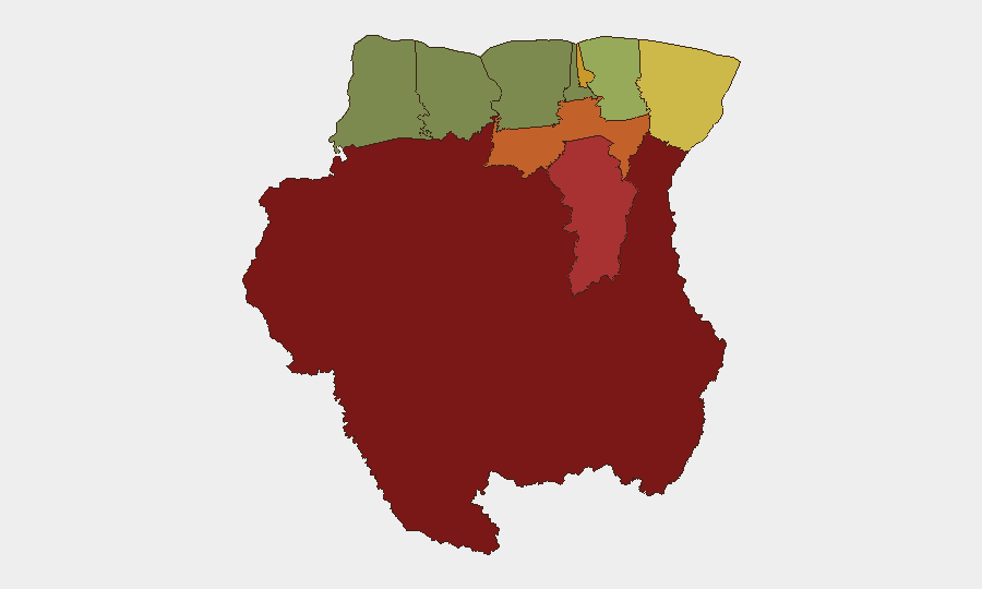
Sipaliwini (risk 92), Brokopondo (78), and Para (74) dominate the sub-national threat ranking and reflect the interior's exposure to trafficking, unregulated mining, smuggling, and limited state presence. Paramaribo (71) and Marowijne (68) rank high owing to urban crime and border-adjacent vulnerabilities respectively. Sipaliwini—the vast southern interior—presents the most acute risk for any corporate presence; lack of infrastructure, indigenous-community friction, and narcotics-transit activity create both security and duty-of-care challenges. Marowijne's proximity to French Guiana and weak customs enforcement elevates cross-border crime and informal economic activity. Paramaribo's ranking reflects street violence, robbery, and gang activity concentrated in specific districts; risk is localized but material for personnel working downtown or in residential areas.
How GeoBit Would Assist
Corporate security teams in Suriname should deploy AOI Monitoring & Early Warning on Paramaribo hotspots (Saramaccastraat, Sunny Point, downtown commercial zones) and interior transit routes to detect emerging disorder, roadblocks, or trafficking checkpoints in near-real time. Intel Sweep, X/Twitter OSINT, and multi-language search would provide 24–48-hour event confirmation and sentiment analysis on labor unrest, police operations, or political friction affecting travel and asset security. Routing & Network Analysis and GIS-based risk mapping enable duty-of-care teams to plan personnel movements, identify safe corridors, and reroute around high-risk zones in Sipaliwini and Marowijne.
7-Day Outlook
Suriname's security trajectory is stable but fragmented: the national threat profile remains low, but localized crime and interior instability are unlikely to change materially in the near term. Personnel and asset security depends on granular, real-time area monitoring rather than national-level alerts. Monitoring for mid-August investigations' outcomes (missing director, stabbing suspects) and any labor or political developments around late August may surface operational friction.
Highest-Risk Areas — Ranked
| # | State / Region | Risk |
|---|---|---|
| 1 | Sipaliwini | 92 |
| 2 | Brokopondo | 78 |
| 3 | Para | 74 |
| 4 | Paramaribo | 71 |
| 5 | Marowijne | 68 |
| 6 | Commewijne | 42 |
| 7 | Wanica | 38 |
| 8 | Saramacca | 29 |
| 9 | Coronie | 12 |
| 10 | Nickerie | 8 |
Sources
Previous Daily Briefs
A new Suriname brief is written every day — each with its own risk map and downloadable CSV. Here's the last week; use the calendar to go further back.
- August 18, 2026
- August 16, 2026
- August 14, 2026
- August 12, 2026
- August 10, 2026
- August 8, 2026
- August 6, 2026
📅 Browse every day by calendar →
Highlighted days have a brief. Tap a day for that day's map & analysis, or “csv” for that day's dataset ($5).
Atlas — our AI intelligence desk — emails them this snapshot personally. Nothing else, no list.