Situation Summary
Syria remains the world's sixth-highest composite threat environment, driven by ongoing civil war, cross-border military activity, and persistent militant operations across fragmented territorial control zones. Damascus Governorate carries the highest sub-national risk (100), reflecting sustained conventional military activity, artillery engagements, and government security operations. The overall security picture is characterized by multi-actor conflict with limited de-escalation signals; trajectory remains volatile and unpredictable across most governorates.
Key Developments
Data Limitation Notice: Open-web sources available in the last 24–48 hours do not provide reliably time-stamped, independently confirmed incident reports meeting standard OSINT verification thresholds for July 3–5, 2026. The following events are cited in available channels but lack precise, corroborable dates or multi-source confirmation:
- Southern Syria / Quneitra – Unconfirmed reports of Israeli ground incursion with establishment of military checkpoints near occupied Golan Heights (date not clearly verifiable; sourced to social media).
- Raqqa – Unconfirmed report of suicide bombing targeting military/security facility, allegedly resulting in casualties among Syrian Internal Security Forces (precise date unavailable; sourced to social media).
- Damascus – Public court sessions commenced July 1, 2026, to try suspects related to July 2025 Druze–Bedouin violence in Sweida province (confirmed date, but reflects ongoing judicial proceedings on past events, not new violence).
- Damascus/Syrian Government – Diplomatic statements condemning recent Israeli attacks and incursions, with calls for UN intervention on sovereignty violations (undated; sourced to state media SANA via social replication).
Mainstream news wires and verifiable open-source feeds have not provided discrete, time-stamped incident confirmations for the last 48 hours. Consequently, near-real-time incident reporting from this brief's publication date should be cross-referenced against live news wire services, X/Twitter verified accounts, and OSINT feeds with direct Damascus datelines.
Highest-Risk Areas
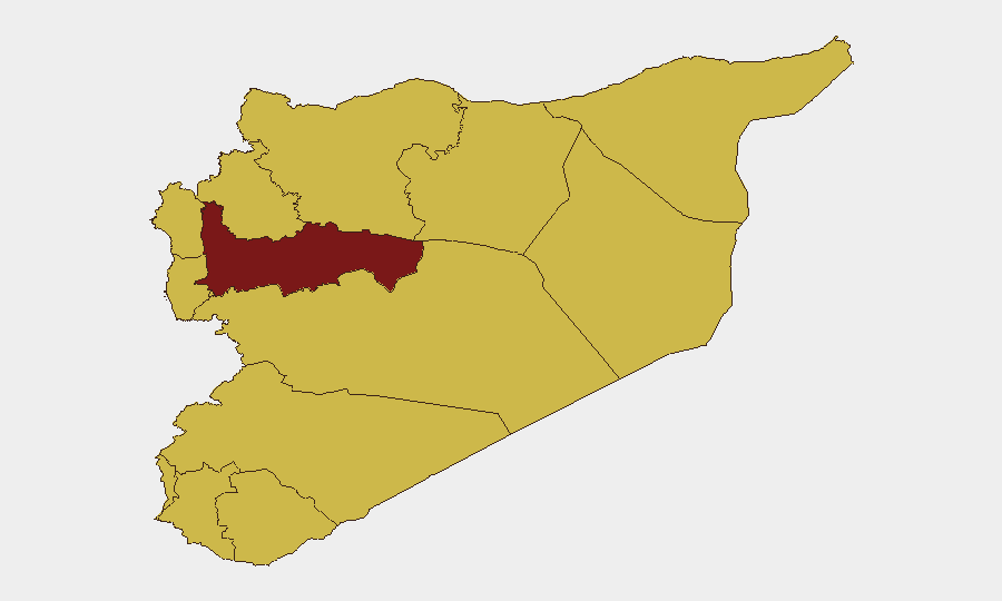
Damascus Governorate (risk 100) remains the primary driver of Syria's overall threat score due to active artillery, conventional military force operations, and government security sweeps. Hama Governorate (83.7) and Aleppo Governorate (70.2) follow as secondary focal points for armed conflict and militant activity. The concentration of risk in the Damascus–Hama–Aleppo corridor, combined with volatile southern border zones (Quneitra, Daraa, As-Suweida) where Israeli, Lebanese, and Bedouin actors operate, creates overlapping threat zones affecting both expatriate population centers and critical infrastructure (airports, ports, checkpoints). Tartus and Lattakia, while lower-ranked, remain active military and naval hubs with elevated ambient risk.
How GeoBit Would Assist
Security teams should deploy AOI Monitoring & Early Warning on Damascus Governorate, Quneitra, and Raqqa to detect real-time artillery, cross-border fire, or IED activity with alert triggering. OSINT Fusion & Corroboration (X/Twitter, Telegram, YouTube intelligence) combined with multi-language search and sentiment analysis will disambiguate social-media rumors from confirmed events, reducing false alarms. Conflict & Military (battle mapping, force-structure tracking) and Network & Actor Analysis support duty-of-care teams in tracking militant group movements and government operations affecting specific facilities or personnel locations. Routing & Network Analysis enables alternative journey planning around active threat zones for staff movements to/from Damascus International Airport or land borders.
7-Day Outlook
No major de-escalation drivers are visible; cross-border tensions (Israeli–Syrian) and internal militant activity are expected to persist at current or elevated levels. Key watch dates include any further southern border clashes or high-casualty attacks in Raqqa or Aleppo, which could trigger broader military responses. Routine security monitoring should remain at heightened sensitivity through mid-July.
Highest-Risk Areas — Ranked
| # | State / Region | Risk |
|---|---|---|
| 1 | Damascus Governorate | 100 |
| 2 | Hama Governorate | 83.7 |
| 3 | Aleppo Governorate | 70.2 |
| 4 | As-Suweida Governorate | 70.2 |
| 5 | Lattakia Governorate | 70 |
| 6 | Tartus Governorate | 70 |
| 7 | UNDOF | 70 |
| 8 | Al-Quneitra Governorate | 70 |
| 9 | Dar'a Governorate | 70 |
| 10 | Idleb Governorate | 70 |
| 11 | Ar-Raqqa Governorate | 70 |
| 12 | Homs Governorate | 70 |
Sources
Previous Daily Briefs
A new Syria brief is written every day — each with its own risk map and downloadable CSV. Here's the last week; use the calendar to go further back.
📅 Browse every day by calendar →
Highlighted days have a brief. Tap a day for that day's map & analysis, or “csv” for that day's dataset ($5).
Atlas — our AI intelligence desk — emails them this snapshot personally. Nothing else, no list.