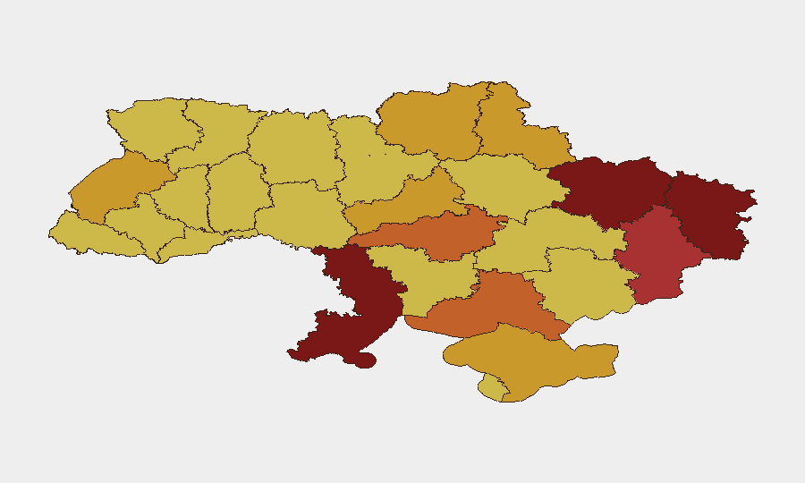
Situation Summary
Ukraine remains the world's highest-risk operating environment, driven by sustained interstate conflict and 1,237 tracked security events. The past 48 hours show intensified Russian aerial strikes on civilian infrastructure and major urban centers—particularly Kyiv, Odesa, and Sumy—concurrent with Ukrainian cross-border drone operations and domestic political unrest linked to defense-leadership changes. Risk is concentrated in eastern and southern oblasts, with Kyiv experiencing the highest absolute threat density due to repeated missile barrages and civil demonstrations.
Key Developments
- Kyiv – nights of 21–22 July: Russian ballistic and cruise-missile barrages struck the capital in multiple waves, killing at least one civilian and wounding 16–20, described as among the largest attacks since the full-scale invasion began in February 2022.
- Odesa & Chornomorsk – 21–22 July: Russian aerial and maritime strikes damaged port infrastructure and disrupted commercial operations, compounding maritime-sector risk in Ukraine's primary export corridors.
- Sumy region (Russia border) – 21–22 July: Cross-border airstrikes and shelling hit civilian areas, causing multiple casualties and reinforcing persistent strike risk in northern Ukraine near the Russian frontier.
- Kharkiv, Dnipropetrovsk, Chornomorsk – 21–22 July: Distributed Russian missile and drone strikes across major urban centers and energy infrastructure killed 11–12 civilians and injured 40+, according to aggregated security reporting.
- Black Sea & Sea of Azov – 21–22 July: Ukraine's Unmanned Systems Forces reported drone strikes on 13 Russian "shadow fleet" vessels, reflecting continued Ukrainian deep-strike operations against sanctioned maritime assets.
- Kyiv & multiple cities – through 22 July: Civil protests linked to President Zelenskyy's dismissal of the defense commander persist, introducing secondary civil-stability and crowd-management risk in the capital and regional centers.
- Eastern front (Donetsk region) – 21–22 July: Heavy ground combat and artillery exchanges continued, with Ukrainian forces claiming incremental advances but facing intensive Russian fire.
Highest-Risk Areas
Kyiv (risk 100) remains the acute epicenter due to intensive aerial targeting of civilian infrastructure, energy systems, and government facilities, combined with active political demonstrations. The southern and eastern oblasts—Luhansk (84.1), Odesa (83.4), Kharkiv (81.3), and Donetsk (77.6)—face compounded risk from conventional military operations, port/infrastructure targeting, and proximity to active front lines. Odesa Oblast's high ranking reflects both maritime strike exposure and critical economic infrastructure; Luhansk and Kharkiv face relentless cross-border fire and ground-combat intensity. Secondary risk zones extend through central and northern oblasts (Kirovohrad, Kherson, Sumy, Chernihiv) due to sporadic strikes, shelling, and logistical disruption.
How GeoBit Would Assist
Security teams should employ AOI Monitoring & Early Warning to track persistent threat patterns in high-risk oblasts (Kyiv, Odesa, Kharkiv, Donetsk) with real-time alerting on strike events and movement near assets. Intel Sweep, OSINT fusion, and multi-language search across Ukrainian and Russian sources provide early signal of tactical shifts, protest activity, and military announcements before mainstream reporting. Routing & Network Analysis enables contingency-path planning for personnel and supply chains avoiding active conflict zones and damaged infrastructure corridors.
7-Day Outlook
Russian aerial operations are expected to sustain or intensify, targeting energy infrastructure and urban centers ahead of potential diplomatic negotiations or operational tempo shifts. Domestic political friction over military leadership may generate secondary instability in Kyiv and regional capitals. Ground-combat intensity in the east will likely persist without significant tactical breakthrough, maintaining elevated casualty and displacement risk in frontline oblasts.
Highest-Risk Areas — Ranked
| # | State / Region | Risk |
|---|---|---|
| 1 | Kyiv | 100 |
| 2 | Luhansk Oblast | 84.1 |
| 3 | Odesa Oblast | 83.4 |
| 4 | Kharkiv Oblast | 81.3 |
| 5 | Donetsk Oblast | 77.6 |
| 6 | Kirovohrad Oblast | 74.6 |
| 7 | Kherson Oblast | 73.5 |
| 8 | Autonomous Republic of Crimea | 72.6 |
| 9 | Cherkasy Oblast | 72.4 |
| 10 | Sumy Oblast | 72 |
| 11 | Lviv Oblast | 71.5 |
| 12 | Chernihiv Oblast | 71 |
Sources
Previous Daily Briefs
A new Ukraine brief is written every day — each with its own risk map and downloadable CSV. Here's the last week; use the calendar to go further back.
📅 Browse every day by calendar →
Highlighted days have a brief. Tap a day for that day's map & analysis, or “csv” for that day's dataset ($5).
Atlas — our AI intelligence desk — emails them this snapshot personally. Nothing else, no list.