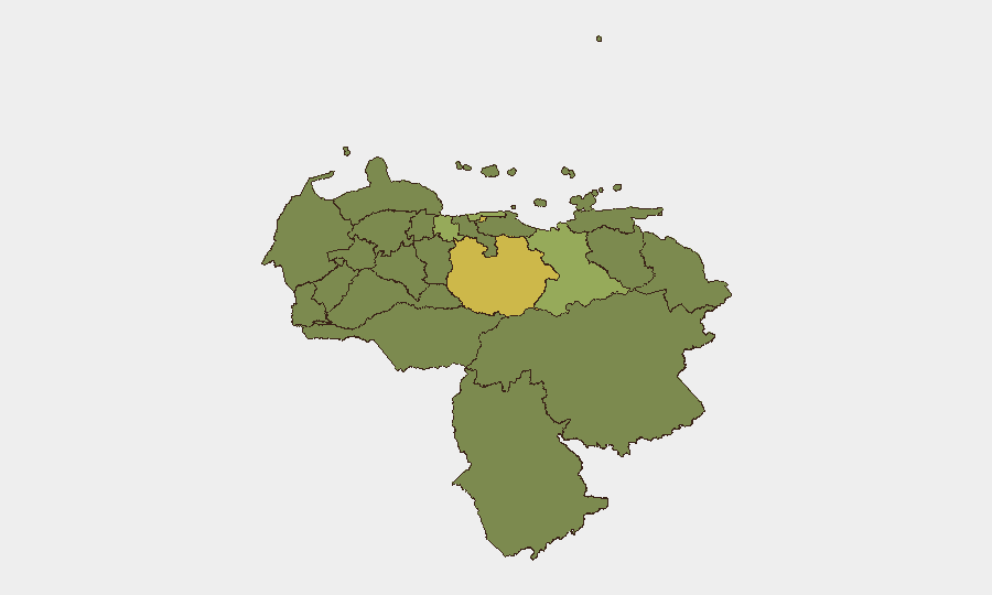
Situation Summary
Venezuela remains in acute crisis following the June 24 double earthquake, which killed an estimated 4,700 people, injured 16,700, and displaced nearly 18,000 across northern states. Infrastructure damage in Caracas, La Guaira, and surrounding municipalities is severe and ongoing; search-and-rescue operations are winding down as of mid-July, but recovery and humanitarian needs remain critical. The security environment is compounded by pre-existing state repression, active armed "colectivos," vehicle checkpoints (alcabalas), and potential for civil unrest around aid distribution and reconstruction. Venezuela's composite threat score of 57 reflects both seismic disruption and underlying political-security fragmentation.
Key Developments
- Caracas, El Junquito parish (18–19 Jul 2026): Acting President Delcy Rodríguez is overseeing active reconstruction operations in El Junquito, a heavily damaged parish on Caracas's outskirts, with ongoing heavy machinery movement and construction activity creating localized access constraints.
- Nationwide, quake-affected northern zones (18 Jul 2026): UN Special Rapporteurs issued a public warning that regulatory barriers are continuing to hinder NGO and humanitarian aid operations, and called for removal of access restrictions and community involvement in reconstruction planning.
- Caracas, La Guaira, and coastal/central states (18–19 Jul 2026): Updated humanitarian assessments confirm 856 buildings destroyed or damaged (including health centers and schools), 6.8 million people affected, and critical ongoing strain on health, education, and basic services across northern municipalities.
- Nationwide, economic policy (18–19 Jul 2026): Venezuela's Economic Council has outlined new "production strategies after the June 24 earthquakes," signaling supply-chain and service volatility (energy, transport, food distribution) as post-quake economic measures are implemented.
- Nationwide, infrastructure (mid-July 2026): German Foreign Office advisory reports intermittent disruption to telephone networks, electricity, and gas supplies across affected regions; politically oriented armed groups and checkpoints remain active alongside earthquake-related service interruptions.
- Nationwide, protection environment (18 Jul 2026): The Global Centre for the Responsibility to Protect classifies Venezuela as a "Current Crisis," noting that ongoing state-led repression may amount to crimes against humanity, now compounded by inadequate government response to catastrophic earthquake damage.
Highest-Risk Areas
Guarico State (69.5) and the Federal District/Caracas (67.6) rank significantly above other regions, reflecting combined exposure to armed-group activity, checkpoint operations, and post-earthquake infrastructure collapse. Carabobo State (46.6) and Vargas State (43.8) follow, driven by damage to coastal and central infrastructure plus persistent organized-crime and political tensions. The concentration of risk in the capital and northern states reflects both earthquake impact and pre-existing governance, criminal, and repression dynamics; southern and eastern states (Zulia, Falcón, Barinas) remain elevated but relatively secondary.
How GeoBit Would Assist
Security teams operating in Venezuela should deploy AOI Monitoring & Early Warning for critical facilities and personnel locations in high-risk states, coupled with Routing & Network Analysis to identify safe transit corridors around active checkpoints and damaged infrastructure. Conflict & Military actor analysis and Telegram/X OSINT tracking of armed-group activity and checkpoint operations, combined with Humanitarian & NGO data integration, enable real-time situational awareness of access constraints and protection risks in quake-affected zones. Sentiment & temporal analysis across local media and social feeds supports early detection of civil unrest or aid-distribution tensions before they escalate.
7-Day Outlook
Reconstruction activity will intensify in Caracas and northern municipalities, with ongoing supply-chain volatility and possible localized road closures. Political tension may rise around adequacy of aid and state response, particularly if NGO access barriers persist. Checkpoint and armed-group activity is likely to remain elevated and unpredictable.
Highest-Risk Areas — Ranked
| # | State / Region | Risk |
|---|---|---|
| 1 | Guarico State | 69.5 |
| 2 | Federal District | 67.6 |
| 3 | Carabobo State | 46.6 |
| 4 | Vargas State | 43.8 |
| 5 | Anzoategui State | 43.2 |
| 6 | Monagas State | 39.8 |
| 7 | Lara State | 39.8 |
| 8 | Zulia State | 39.5 |
| 9 | Falcon State | 39.5 |
| 10 | Federal Dependencies | 39.5 |
| 11 | Nueva Esparta State | 39.5 |
| 12 | Barinas State | 39.5 |
Sources
Previous Daily Briefs
A new Venezuela brief is written every day — each with its own risk map and downloadable CSV. Here's the last week; use the calendar to go further back.
📅 Browse every day by calendar →
Highlighted days have a brief. Tap a day for that day's map & analysis, or “csv” for that day's dataset ($5).
Atlas — our AI intelligence desk — emails them this snapshot personally. Nothing else, no list.